Vessel Operation Restriction Regulations SOR/2008-120 Registration April 17, 2008
CANADA SHIPPING ACT, 2001
Vessel Operation Restriction Regulations P.C. 2008-774 April 17, 2008
Her Excellency the Governor General in Council, on the recommendation of the Minister of Transport, Infrastructure and Communities, pursuant to sections 136a and 207 of the Canada Shipping Act, 2001b, hereby makes the annexed Vessel Operation Restriction Regulations.a S.C. 2005, c. 29, s.18
b S.C. 2001, c. 26
Vessel Operation Restriction Regulations
INTERPRETATION
1. The following definitions apply in these Regulations.
"electrical propulsion" means a mode of propulsion provided by a main propelling machinery that is an electric motor powered by electric cells. ( propulsion électrique )
"engine power" means the engine power, in kilowatts, calculated in accordance with International Standard ISO 8665, Small Craft - Marine Propulsion Engines and Systems - Power Measurements and Declarations, second edition, August 1, 1994. ( puissance motrice )
"local authority" means a government of a municipality, township, parish, county or regional district, any other government constituted under the laws of a province or territory, or a department of a provincial or territorial government or of the federal government. ( administration locale )
"Minister" means the Minister of Transport. ( ministre )
"personal watercraft" means a water-jet driven vessel with an enclosed hull and no cockpit that is designed to be used by one or more persons who are straddling, sitting, standing or kneeling. ( motomarine )
"power-driven" means a mode of propulsion provided by a main propelling machinery that is an internal combustion engine or a steam engine. ( propulsion mécanique )
"provincial authority" means a department of the government of a province designated by that government to process requests to impose restrictions on the operation of vessels in respect of waters within that province. ( autorité provinciale )
"rivers and lakes" includes all those waters of any river upstream of a line between the most seaward extremities of the shore of the river at high tide but does not include the waters of the St. Lawrence River east of 70°53' W longitude. ( fleuves, rivières et lacs )
RESTRICTIONS
Operation of Vessels
2. (1) No person shall operate a vessel in any of the waters described in Schedule 1, except as indicated in that Schedule. (2) No person shall operate a power-driven vessel or a vessel driven by electrical propulsion in any of the waters described in Schedule 2, except as indicated in that Schedule. (3) No person shall operate a power-driven vessel in any of the waters described in Schedule 3, except as indicated in that Schedule.
(4) No person shall operate a power-driven vessel or a vessel driven by electrical propulsion that has an engine power greater than the maximum engine power set out in column 4 of Schedule 4 in waters in public parks and controlled access bodies of water described in columns 1 to 3 of that Schedule. (5) No person shall operate a power-driven vessel or a vessel driven by electrical propulsion in the waters described in columns 1 to 3 of Schedule 5 or 6 in excess of the maximum speed set out in column 4 of that Schedule, except as indicated in that Schedule. (6) No person shall operate a power-driven vessel or a vessel driven by electrical propulsion in the waters described in Schedule 7 for the purpose of towing a person on water skis, a surf board or any other similar equipment, except during the permitted hours set out in that Schedule, if any.
(7) No person shall operate a power-driven vessel at a speed in excess of 10 km/h within 30 m of the shore in the following waters:
(a) the waters of Ontario, Manitoba, Saskatchewan and Alberta;
(b) the rivers and lakes in British Columbia;
(c) Nitinat River and Nitinat Lake, upstream of Nitinat Bar, in British Columbia;
(d) the rivers and lakes in Nova Scotia; and
(e) Bras d'Or Lake in Nova Scotia, inland of a line drawn between Coffin Point and Red Head in Great Bras d'Or Channel and the inland end of St. Peters Canal.
(8) Subsection (7) does not apply
(a) in respect of a vessel that is operated for the purpose of towing a person on water skis, a surf board or any other similar equipment if
(i) the vessel follows a trajectory perpendicular to the shore, and
(ii) the operation takes place within an area designated by buoys as an area in which that operation is permitted; or
(b) in respect of a power-driven vessel that is operated
(i) in rivers that are less than 100 m in width or in canals or buoyed channels, or
(ii) in any waters referred to in Schedule 5 or 6 in respect of which a maximum speed is set out.
(9) Subsections (5) and (7) do not apply to a vessel that is required to comply with another speed limit established under the Canada Shipping Act, 2001 or the Canada Marine Act.
3. (1) Subsections 2(1) to (4) do not apply to
(a) a person who occupies a waterfront property that is not accessible by road and operates a vessel solely for the purpose of gaining access to that property; or
(b) a person who holds a provincial fishing permit and whose livelihood depends on fishing.
(2) Subsections 2(1) to (5) and (7) do not apply to
(a) an enforcement officer acting within the scope of their duties;
(b) an employee or agent or mandatary of Her Majesty in right of Canada or a province, or of a county, municipality or regional district, acting within the scope of their duties;
(c) a person rescuing someone or preventing damage to property; or
(d) a person who operates a safety boat for surveillance, rendering assistance and lifeguarding within the scope of regular activities carried out by a recreational institution or a teaching or racing organization established under provincial, federal or international laws.
4. If a local authority seeks, in respect of certain waters, the imposition of a restriction that is of the same nature as a restriction imposed by section 2 or 11, the local authority shall submit to the provincial authority in the province for which the restriction is proposed, or to the Minister if no provincial authority exists, a request together with a report that specifies the location of the waters, the nature of the proposed restriction, information regarding the public consultations held, particulars regarding the implementation of the proposed restriction and any other information that is necessary to justify regulatory intervention.
Signs
5. No person shall place a sign anywhere for the purpose of restricting the operation of any vessel in Canadian waters unless
(a) the placement has been authorized by the Minister under subsection 6(1) and the sign complies with sections 8 and 9, except in the case of a sign that provides information with respect to a restriction under subsection 2(7) or section 14; or
(b) the placement is authorized under an Act of Parliament other than the Canada Shipping Act, 2001.
6. (1) The Minister may authorize in writing any person or class of persons to place a sign in an area for the purpose of indicating that a restriction on the operation of vessels has been established by subsections 2(1) to (6) or section 11 in respect of that area.
(2) The person who places the sign shall
(a) bear all costs of construction, placing, maintenance and removal; and
(b) maintain the sign in the form required by sections 8 and 9 while the sign is in place.
(3) If a restriction in any of the schedules is removed, the Minister shall cancel the authorization and inform the person of the cancellation.
(4) On being so informed by the Minister, the person who placed the sign shall immediately remove it as well as any support erected for it.
7. A person who is informed by the Minister that the person has placed an unauthorized sign shall remove it immediately.
8. (1) A person authorized to place a sign shall ensure that the sign is in one of the following forms, according to the restriction applied:
(a) the symbol shown under letter C of Table 1 to Schedule 9, to indicate an area in which vessels are prohibited;
(b) a disc bordered by a band coloured international orange, as shown in Figure 1 of Table 3 to Schedule 9, in conjunction with two of the symbols shown in Table 1 to that Schedule, to indicate a single restriction;
(c) an elongated circle bordered by a band coloured international orange, as shown in Figure 4 of Table 3 to Schedule 9, in conjunction with two or more of the symbols shown in Table 1 to that Schedule, to indicate multiple restrictions; or
(d) a half-disc bordered by a band coloured international orange above a black line surmounting a half-rectangle bordered by a band coloured green, as shown in Figure 5 of Table 3 to Schedule 9, in conjunction with, in the half-disc, the appropriate symbols shown in Table 1 to that Schedule and, in the half-rectangle, the symbols shown in Table 2 to that Schedule, to indicate the applicable conditions to the restriction.
(2) A directional disc bordered by a band coloured international orange, as shown in Figure 2 or 3 of Table 3 to Schedule 9, may be substituted for the disk referred to in paragraph (1)(b) to indicate the boundary of the waters to which the restriction applies and, by means of the directional disc pointer, the side on which the restriction applies.
(3) An information rectangle bordered by a band coloured international orange, as shown in Figure 6 of Table 3 to Schedule 9, may be placed underneath the sign referred to in subsection (1) to provide any additional information on the restriction indicated on that sign.
(4) The width of the band coloured international orange referred to in this section shall be one twelfth of the width or diameter of the sign.
(5) A sign that is authorized by the Minister, or one that was authorized under the Boating Restriction Regulations and that is replaced, shall be marked at the lower edge in black with the words "TRANSPORT CANADA" and "TRANSPORTS CANADA".
9. (1) Where it appears on a sign referred to in section 8,
(a) the diagonal bar shown under letter B of Table 1 to Schedule 9 crossing behind one of the other symbols shown in that Table indicates a prohibition of the usage or activity indicated by the symbol being crossed by the diagonal bar;
(b) the propeller symbol shown under letter D of Table 1 to Schedule 9 in conjunction with the diagonal bar shown under letter B of that Table indicates that no power-driven vessel or vessel driven by electrical propulsion shall be operated on the waters in respect of which the sign has been placed;
(c) the symbol shown under letter E of Table 1 to Schedule 9, consisting of a propeller superimposed by a gas pump in conjunction with the diagonal bar shown under letter B of that Table, indicates that no power-driven vessel shall be operated on the waters in respect of which the sign has been placed;
(d) the symbol consisting of a number shown under letter A of Table 1 to Schedule 9 above the expression "MAX kW" shown under letter F of that Table indicates that no power-driven vessel with an engine whose power exceeds the power in kilowatts represented by that number shall be operated on the waters in respect of which the sign has been placed;
(e) the symbol consisting of a number shown under letter A of Table 1 to Schedule 9 above the expression "MAX km/h" shown under letter G of that Table indicates that no power-driven vessel shall be operated at a speed in excess of the speed over the ground, in kilometres per hour, represented by that number on the waters in respect of which the sign has been placed; and
(f) the symbol consisting of the word "SKI" shown under letter H of Table 1 to Schedule 9 in conjunction with the diagonal bar shown under letter B of that Table indicates that no power-driven vessel shall be operated for the purpose of towing a person on water skis, a surf board or any other similar equipment on the waters in respect of which the sign has been placed.
(2) If a prohibition referred to in subsection (1) applies only during specified periods, the following symbols shall appear on a sign referred to in section 8:
(a) if the prohibition applies to certain hours of the day, the clock shown under letter A of Table 2 to Schedule 9, to indicate, in red, the hours during which the prohibition applies and, in green, the hours during which it is permitted to practise the activity otherwise prohibited by the sign;
(b) if the prohibition applies to certain days of the week, the series of seven squares shown under letter B of Table 2 to Schedule 9 in which appears in English and in French the first letter in white of each day of the week, to indicate, in red, the days on which the prohibition applies and, in green, the days on which it is permitted to practise the activity otherwise prohibited by the sign; and
(c) if the prohibition applies to certain months of the year, the series of eight squares shown under letter C of Table 2 to Schedule 9 in which appears the first letter in white of the months of April to November inclusive, to indicate, in red, the months during which the prohibition applies and, in green, the months during which it is permitted to practise the activity otherwise prohibited by the sign.
(3) If a prohibition referred to in subsection (1) applies only to a sector of a body of water from a marked geographical point or line in the cardinal direction of that sector, the person authorized by the Minister to place a sign shall place it at that point or line together with an additional sign bearing the black compass rose shown under letter D of Table 2 to Schedule 9 within a square, with one or more sections coloured international orange.
(4) For the purpose of subsection (3), the following sections of the compass rose, coloured international orange, indicate the cardinal directions of the sector to which the prohibition applies:
(a) upper right and left corners, north;
(b) upper right corner, northeast;
(c) upper and lower right corners, east;
(d) lower right corner, southeast;
(e) lower left and right corners, south;
(f) lower left corner, southwest;
(g) upper and lower left corners, west; and
(h) upper left corner, northwest.
(5) If a sign authorized by the Minister is placed directly on a buoy, a horizontal band shall be marked immediately above and immediately below the sign such that each band
(a) is one twelfth of the sign width;
(b) is coloured international orange; and
(c) extends all around the buoy.
10. No person shall
(a) remove any authorized sign unless the authorization has been cancelled;
(b) alter, conceal, damage or destroy any authorized sign; or
(c) use any authorized sign or any support erected for it as a mooring.
Special Events or Activities
11. (1) No person shall hold a sporting, recreational or public event or activity in waters other than those described in Schedule 8 in a manner or at a place that would unreasonably interfere with the safe and efficient navigation of vessels.
(2) No person shall hold a sporting, recreational or public event or activity in the waters described in Schedule 8 unless the person is authorized to do so by a permit issued under subsection 12(1).
(3) No person shall hold, in the waters described in subsection 2(7) or in Schedule 5 or 6, a sporting, recreational or public event or activity, during which vessels will be operated at a speed that exceeds the maximum speed prescribed by these Regulations in respect of those waters unless the person is authorized by a permit issued under subsection 12(2).
12. (1) The Minister may issue a permit that authorizes a person to hold a sporting, recreational or public event or activity in the waters described in Schedule 8 and that sets out conditions
(a) to minimize risk to the safety of persons and interference with the safe and efficient navigation of vessels; and
(b) to protect the public interest.
(2) The Minister may issue a permit authorizing a person to hold, in the waters described in subsection 2(7) or in Schedule 5 or 6, a sporting, recreational or public event or activity during which vessels will be operated at a speed that exceeds the maximum speed prescribed by these Regulations in respect of those waters, and that sets out conditions
(a) to minimize risk to the safety of persons and interference with the safe navigation of vessels; and
(b) to protect the public interest.
(3) The person in whose name a permit to hold a sporting, recreational or public event or activity is issued and all persons taking part in the event or activity shall comply with the conditions set out in the permit.
(4) The Minister may cancel a permit if the person in whose name the permit was issued or persons taking part in the event or activity do not comply with the conditions set out in the permit.
(5) If the permit is cancelled, the Minister shall give notice of the cancellation to the person in whose name the permit was issued.
Anchorage in False Creek
13. In section 14, "anchor" includes securing a vessel to a mooring buoy or attaching it to another vessel that is anchored.
14. (1) No person shall, unless the person holds a permit issued by the Minister, anchor a vessel within the waters of False Creek in the City of Vancouver that are east of a line drawn 45° true from Kitsilano Point to the north shore of False Creek
(a) for a cumulative period of more than eight hours between 9:00 a.m. and 11:00 p.m.; or
(b) any time between 11:00 p.m. of one day and 9:00 a.m. of the following day.
(2) The Minister shall issue a permit for a maximum period set out in subsection (3) or (4) if
(a) the owner or operator of a vessel submits to the Minister a signed application providing the following information:
(i) the number of days that the vessel would be anchored,
(ii) the name and permanent address of the applicant,
(iii) the telephone number or the place where the applicant may be contacted during the period of the permit, and
(iv) the vessel's identification;
(b) the vessel is seaworthy; and
(c) there is space available to anchor the vessel.
(3) A permit is valid for a maximum period of
(a) 14 days for a permit issued during the summer, being the period beginning on April 1 and ending on September 30; and
(b) 21 days for a permit issued during the winter, being the period beginning on October 1 and ending on March 31.
(4) The owner or operator of a vessel may apply for another permit to anchor the vessel for a maximum period, calculated as follows:
(a) for permits issued during the summer, 14 days less the number of full or partial days that the vessel was anchored during the 30 days before the day of the application; and
(b) for permits issued during the winter, 21 days less the number of full or partial days that the vessel was anchored during the 40 days before the day of the application.
(5) This section does not apply to the following persons acting within the scope of their duties:
(a) an enforcement officer; or
(b) an employee or agent or mandatary of Her Majesty in right of Canada or a province, or of a county, municipality or regional district.
SAFE OPERATION
[SOR/2008-120, err., Vol. 142, No. 10]
15. (1) A person who operates a vessel shall do so in a safe manner and
(a) shall take into account any circumstances that could pose a danger to the vessel or to other vessels; and
(b) shall avoid endangering the safety of persons involved in any activity in any waters.
(2) In order to ensure the safety of persons during a sporting, recreational or public event or activity for which a permit has been issued, a person who operates a vessel shall do so in a manner that does not interfere with the event or activity.
ENFORCEMENT
16. For the purpose of ensuring compliance with sections 2 to 15, the persons or classes of persons set out in the table to this section are appointed or specified as enforcement officers.
TABLE
| |
Column 1 |
Column 2 |
| Item |
Persons or classes of persons |
Geographic location, if applicable |
| 1. |
A member of the Royal Canadian Mounted Police |
|
| 2. |
A member of any harbour or river police force |
|
| 3. |
A member of any provincial, county or municipal police force |
|
| 4. |
A marine safety inspector |
|
| 5. |
A pleasure craft safety inspector |
|
| 6. |
A person employed as park warden by Parks Canada and appointed under the Canada National Parks Act |
|
| 7. |
A person employed as marine conservation area warden by Parks Canada and appointed under the Canada National Marine Conservation Areas Act |
|
| 8. |
A person employed as conservation officer by the National Capital Commission |
|
| 9. |
A person employed as fishery officer by the Department of Fisheries and Oceans in British Columbia and Yukon |
In British Columbia, Yukon and their adjacent waters |
| 10. |
A member of the British Columbia Conservation Officer Service appointed under the British Columbia Environmental Management Act, S.B.C. 2003, c. 53 |
|
| 11. |
A conservation officer appointed under the Alberta Government Organization Act, R.S.A. 2000, c. G-10 |
|
| 12. |
A forest officer appointed under the Alberta Forests Act, R.S.A. 2000, c. F-22 |
|
| 13. |
A wildlife officer appointed under the Alberta Wildlife Act, R.S.A. 2000, c. W-10 |
|
| 14. |
A bylaw enforcement officer employed by the Town of Chestermere, in Alberta |
In Alberta |
| 15. |
A community peace officer - Level 1, employed by the Alberta Special Areas Board and appointed under the Alberta Peace Officer Act, S.A. 2006, c. P-3.5 |
|
| 16. |
A special constable employed by the Wascana Centre Authority and appointed under The Wascana Centre Act, R.S.S. 1978, c. W-4, Saskatchewan |
|
| 17. |
A person employed as conservation officer by the Saskatchewan Department of Environment and appointed as special constable under The Police Act, 1990, S.S. 1990-1991, c. P-15.01 |
|
| 18. |
A special constable or municipal inspector for the following entities in Quebec: |
|
| Municipality of Austin, Municipality of Ayer's Cliff, Township Municipality of Potton, Township Municipality of Stanstead, Township of Hatley, Municipality of Hatley, City of Magog, Regional Municipality of Memphrémagog, Town of North Hatley, Municipality of Ogden, Municipality of Sainte-Catherine-de-Hatley, Municipality of Adstock, Municipality of Lambton, Municipality of Saint-Romain, Municipality of Saint-Joseph-de-Coleraine, Municipality of Sainte-Praxède, Municipality of Stornoway, City of Lac-Brome and Municipality of Saint-Ferdinand |
| 19. |
A person employed as conservation officer by the Nova Scotia Department of Natural Resources |
|
| 20. |
A peace officer or special constable appointed under the Nova Scotia Police Act, S.N.S. 2004, c. 31, who operates in the Halifax Regional Municipality in Nova Scotia |
In the Halifax Regional Municipality |
17. An enforcement officer may
(a) direct or prohibit the movement of any vessel; and
(b) stop and board any vessel at any reasonable time, and
(i) direct any person to put into operation or cease operating any equipment on board the vessel,
(ii) ask any pertinent questions of, and demand all reasonable assistance from, any person on board the vessel, and
(iii) require that any person on board the vessel provide to the enforcement officer, for examination, any document or information that is in the person's possession.
AGE RESTRICTIONS
18. Sections 19 to 21 apply in respect of a pleasure craft that is operated for recreational purposes in Canadian waters, other than in the waters of the Northwest Territories and Nunavut.
19. No person who is under 12 years of age shall operate, and no person shall allow a person who is under 12 years of age to operate, a pleasure craft, other than a personal watercraft, propelled by a motor with an engine power greater than 7.5 kW, unless the person is accompanied and directly supervised in the pleasure craft by a person who is 16 years of age or older.
20. No person who is under 16 years of age shall operate, and no person shall allow a person who is under 16 years of age to operate, a pleasure craft, other than a personal watercraft, propelled by a motor with an engine power greater than 30 kW, unless the person is accompanied and directly supervised in the pleasure craft by a person who is 16 years of age or older.
21. No person who is under 16 years of age shall operate, and no person shall allow a person who is under 16 years of age to operate, a personal watercraft.
REPEAL
22. [Repeal]
COMING INTO FORCE
23. These Regulations come into force on the day on which they are registered.
SCHEDULE 1
(Subsection 2(1))
WATERS ON WHICH ALL VESSELS ARE PROHIBITED PART 1
ALBERTA
| |
Column 1 |
Column 2 |
Column 3 |
| Item |
Name Given by the Gazetteer of Canada or Description |
Local Name |
Location Reference (Alberta Land Titles Act Reference System) |
| Southern Region |
| 1. |
Elkwater Lake, as indicated by signs |
|
23,25-8-3-W4 |
| 2. |
Outpost Lake, as indicated by signs |
Police Lake |
1-26-W4 |
| 3. |
Beauvais Lake, as indicated by signs |
|
29-5-1-W5 |
| 4. |
Unnamed lake, as indicated by signs |
Park Lake |
9,10-22-W4 |
| 5. |
Lee Lake, as indicated by signs |
|
7,8-7-2-W5 |
| 6. |
St. Mary Reservoir, as indicated by signs |
|
4-24,25-W4 |
| 7. |
Newell Lake, as indicated by signs |
|
17-15-W4 |
| 8. |
Travers Reservoir, as indicated by signs |
|
31-14-21-W4 |
| 9. |
Keho Lake, as indicated by signs |
|
11-22,23-W4 |
| 10. |
Stafford Reservoir, as indicated by signs |
Chin Lakes |
9-19-W4 |
| 11. |
Beaver Mines Lakes, as indicated by signs |
|
11-5-3-W5 |
| 12. |
Milk River Ridge Reservoir, as indicated by signs |
|
|
| Ridge Reservoir |
5-20-W4 |
| 13. |
Chain Lakes, as indicated by signs |
|
14,15-2-W5 |
| 14. |
That portion of the Oldman River between the Bitango Bridge in 30-7-29-W4 and the Oldman River Dam Project access bridge in |
|
27-11-13-W4 |
| 16-7-29-W4 |
| Central Region |
| 1. |
Little Fish Lake, as indicated by signs |
|
28-16-W4 |
| 2. |
Bow River at Carseland Weir, as indicated by signs |
|
31,32-21-25-W4 |
| 3. |
Unnamed lake |
Sikome Lake |
25-1-22-W5 |
| 4. |
Unnamed reservoir |
Cipperley's Reservoir |
8-32-1-W5 |
| 5. |
Unnamed reservoir |
Hwy No. 2 (Harris) Reservoir |
36-44-25-W4 |
| 6. |
Unnamed lake, as indicated by signs |
Lacombe Experimental Farm Pond |
24-40-27-W4 |
| 7. |
Unnamed reservoir |
Ponoka Centennial Park Reservoir |
43-25-W4 |
| 8. |
Unnamed reservoir |
Simpson Reservoir |
12-35-6-W4 |
| 9. |
Gull Lake, as indicated by signs |
|
41-28-W4 |
| 10. |
Gooseberry Lake, as indicated by signs |
|
36-5,6-W4 |
| 11. |
Miquelon Lakes, as indicated by signs |
|
49-20,21-W4 |
| 12. |
Buffalo Lake, as indicated by signs |
|
25-40-21-W4 |
| 13. |
Pine Lake, as indicated by signs |
|
36-24,25-W4 |
| 14. |
Unnamed reservoir |
Tees Reservoir |
25-40-24-W4 |
| 15. |
Unnamed reservoir |
Hwy No. 2 Reservoir |
22-42-26-W4 |
| 16. |
Unnamed lake |
Prins' Pond |
25-40-28-W4 |
| 17. |
Unnamed lake |
Owen's Pond |
28-45-10-W4 |
| 18. |
Unnamed lake |
Wallace Park Pond |
44-6-W4 |
| 19. |
Unnamed lake |
Monitor Pond |
6-35-4-W4 |
| 20. |
Sylvan Lake, as indicated by signs |
|
39-1-2-W5 |
| 21. |
Unnamed lake, as indicated by signs |
Hardisty Lake |
1-43-10-W4 |
| 22. |
Unnamed lake, as indicated by signs |
Keivers Lake |
25-31-26-W4 |
| 23. |
Red Deer Lake, as indicated by signs |
|
43-21,22-W4 |
| 24. |
Twin Lakes West, as indicated by signs |
|
9-46-3-W5 |
| 25. |
Bow River at Western Irrigation District Weir Calgary, as indicated by signs |
|
13-24-1-W5 |
| 26. |
Buck Lake, as indicated by signs |
|
46-6-W5 |
| 27. |
Pigeon Lake, as indicated by signs |
|
47-1-W5 |
| 28. |
Gleniffer Lake, as indicated by signs |
Dickson Reservoir |
35-2,3-W5 |
| 29. |
Red Deer River, as indicated by signs |
|
36-2-W5 |
| East Slopes Region |
| 1. |
Jarvis Lake, as indicated by signs |
|
52-26-W5 |
| 2. |
Gregg Lake, as indicated by signs |
|
52,53-26-W5 |
| 3. |
Unnamed lake, as indicated by signs |
Bear Lake |
10-55-15-W5 |
| 4. |
McLeod Lake, as indicated by signs |
Carson Lake |
61-11,12-W5 |
| 5. |
Unnamed lake, as indicated by signs |
Pegasus Lake |
61-11-W5 |
| 6. |
Goose Lake, as indicated by signs |
|
61-8-W5 |
| 7. |
Wolf Lake, as indicated by signs |
|
49-14-W5 |
| 8. |
Unnamed lake |
Rocky Fish and Game Pond |
33-39-7-W5 |
| Northeast Region |
| 1. |
Garner Lake, as indicated by signs |
|
60-12-W4 |
| 2. |
Unnamed lake, as indicated by signs |
Long Lake |
63-19-W4 |
| 3. |
Moose Lake, as indicated by signs |
|
60,61-6,7-W4 |
| 4. |
Lac la Biche, as indicated by signs |
|
68-15-W4 |
| 5. |
Unnamed reservoir, as indicated by signs |
Vermilion Reservoir |
50-6-W4 |
| 6. |
Gregoire Lake, as indicated by signs |
|
13-86-8-W4 |
| 7. |
Whitney Lake, as indicated by signs |
|
16,17-56-4-W4 |
| 8. |
Cold Lake, as indicated by signs |
|
63,65-1,2-W4 |
| 9. |
Touchwood Lake, as indicated by signs |
|
67-10-W4 |
| 10. |
Beaver Lake, as indicated by signs |
|
66-12,13-W4 |
| 11. |
Manatokan Lake, as indicated by signs |
|
63-7-W4 |
| 12. |
Namur Lake, as indicated by signs |
|
97-17-W4 |
| 13. |
Lower Thérien Lake, as indicated by signs |
|
57-10-W4 |
| 14. |
Floatingstone Lake, as indicated by signs |
Boyne Lake |
60-11-W4 |
| 15. |
Thunder Lake |
|
59-5,6-W5 |
| 16. |
Wabamun Lake, as indicated by signs |
|
52,53-4,5-W5 |
| 17. |
Jack Fish Lake, as indicated by signs |
|
52-2-W5 |
| 18. |
Lac Ste. Anne, as indicated by signs |
|
54,55-3,4-W5 |
| 19. |
Lac la Nonne, as indicated by signs |
|
57-2,3-W5 |
| 20. |
Steele Lake, as indicated by signs |
Cross Lake |
65-25,26-W4 |
| 21. |
Calling Lake, as indicated by signs |
|
33-72-22-W4 |
| 22. |
Halfmoon Lake, as indicated by signs |
|
58-23-W4 |
| 23. |
Unnamed lake |
Morinville Pond |
5-56-25-W4 |
| 24. |
Unnamed lake |
Westlock Pond |
31-59-25-W4 |
| 25. |
Unnamed lake |
Namepi Reservoir |
14-58-20-W4 |
| 26. |
Sandy Lake, as indicated by signs |
|
55,56-1-W5 |
| 27. |
Isle Lake, as indicated by signs |
|
53,54-5,6-W5 |
| 28. |
Dillberry Lake, as indicated by signs |
|
41,42-1-W4 |
| 29. |
Wizard Lake, as indicated by signs |
|
48-27,28-W4 |
| 30. |
Shorncliffe Lake, as indicated by signs |
|
40-6,7-W4 |
| 31. |
Unnamed lake, as indicated by signs |
Hasse Lake |
13-52-2-W5 |
| 32. |
Lac Santé, as indicated by signs |
Big Fish Lake |
56-11-W4 |
| 33. |
Vincent Lake, as indicated by signs |
|
59-9,10-W4 |
| 34. |
Bonnie Lake, as indicated by signs |
|
59,60-13-W4 |
| 35. |
Fork Lake, as indicated by signs |
|
63-11-W4 |
| 36. |
North Buck Lake, as indicated by signs |
|
66-17-W4 |
| 37. |
Hanmore Lake, as indicated by signs |
|
61-17,18-W4 |
| 38. |
Jackfish Lake, as indicated by signs |
|
67-21-W4 |
| 39. |
Moore Lake, as indicated by signs |
|
64-4-W4 |
| 40. |
Skeleton Lake, as indicated by signs |
|
65-18,19-W4 |
| 41. |
Camp Lake, as indicated by signs |
|
10-48-11-W4 |
| 42. |
Long Island Lake, as indicated by signs |
|
63-25,26-W4 |
| 43. |
Muriel Lake, as indicated by signs |
|
59,60-5-W4 |
| 44. |
Ross Lake |
|
53°50' |
| 110°30' |
| 45. |
Half Moon Lake |
Half Moon Lake |
53°35' |
| 113°28' |
| 46. |
Baptiste Lake, as indicated by signs |
Baptiste Lake |
66-24-W4 |
| Peace River Region |
| 1. |
Cardinal Lake, as indicated by signs |
Cardinal Lake |
83-24-W5 |
| 2. |
Lesser Slave Lake, as indicated by signs |
|
19-75-12-W5 |
| 3. |
Saskatoon Lake, as indicated by signs |
|
72-7,8-W6 |
| 4. |
Sturgeon Lake, as indicated by signs |
|
70-23-W5 |
| 5. |
Winagami Lake, as indicated by signs |
|
76,77-18,19-W5 |
| 6. |
Mirage Lake, as indicated by signs |
Moonshine Lake |
79-8-W6 |
| 7. |
Musreau Lake, as indicated by signs |
|
64-5-W6 |
| 8. |
Rycroft Pond |
|
15-78-5-W6 |
| 9. |
Grimshaw Agricultural Society Pond # 1 |
|
27-83-23-W5 |
| 10. |
Lesser Slave River, as indicated by signs |
|
73-5-W5 |
| 11. |
Fawcett Lake, as indicated by signs |
|
73-26-W4 | PART 2
ONTARIO
| |
Column 1 |
Column 2 |
Column 3 |
| Item |
Name Given by the Gazetteer of Canada or Description |
Specific Location |
Location Reference (Gazetteer of Canada Reference System) |
| 1. |
That part of the Niagara River that lies within Canada and that is between |
|
43°16' 79°03' |
| |
(a) a straight line joining the end of the breakwater at the mouth of the Welland River to the westerly side of the mouth of Gill Creek at Niagara Falls, New York; and |
|
|
| (b) the crest of the Horseshoe Falls at Niagara Falls, Ontario |
| 2. |
That part of Wilcox Lake that is a zone extending 75 m into the lake, commencing at a point where a stream enters the lake on the northeast shore, having as a reference 43°57'00? N and 79°25'50? W, thence following the shoreline in a southerly and easterly direction to a point opposite the end of the 5th side road (Bethesda Road), having as a reference 43°56'45? N and 79°25'40? W |
|
43°57' 79°26' |
| 3. |
That part of the Thames River that is within the City of London, Ontario, and its environs, between |
42°59' 81°14' |
42°19' 82°27' |
| |
(a) Fanshawe Dam on the north branch; |
|
|
| (b) the Hamilton Road bridge on the south branch; and |
| (c) downstream, beyond the junction of the north and south branches to the Delaware Bridge on Hwy 2 |
| Note: Closed only during high water periods when the water level is at an elevation of 226.5 m G.D.C. or higher, measured at the Byron gauge |
| 4. |
That part of Big Tub Harbour, Tobermory, enclosed by the following positions: |
|
45°16' 81°41' |
| 45°15'19.5? N 81°40'51? W, 45°15'19.5? N 81°40'54? W, 45°15'17? N 81°40'54? W and 45°15'17? N 81°40'51? W |
| 5. |
That part of Tobermory Harbour adjacent to the shore near the lighthouse on Lighthouse Point and enclosed by the following positions: beginning at a point on shore at approximately 45°15'29? N 81°40'23? W to 45°15'29? N 81°40'20? W to 45°15'26? N 81°40'20? W to another point on shore at approximately 45°15'26? N 81°40'25? W |
|
45°16' 81°40' |
| 6. |
That part of Tobermory Harbour adjacent to the shore along the east side and enclosed by the following positions: beginning at a point on shore at approximately 45°15'25? N 81°39'44? W to 45°15'35? N 81°39'44? W to another point on shore at approximately 45°15'35? N 81°39'39? W |
|
45°16' 81°40' |
| 7. |
That part of Lake Huron on the northwest bank and enclosed by the following positions: 45°16'12? N 81°45'00? W, 45°16'18? N 81°45'00? W, 45°16'18? N 81°45'18? W and 45°16'08? N 81°45'18? W |
|
45°17' 81°45' |
| 8. |
That part of Lake Huron adjacent to the easterly shore of Russel Island and enclosed by the following positions: beginning at a point on shore at approximately 45°15'59? N 81°41'17? W to 45°15'59? N 81°41'12? W to 45°15'54? N 81°41'12? W to another point on shore at approximately 45°15'54? N 81°41'23? W |
|
45°16' 81°42' |
| 9. |
That part of Lake Huron adjacent to the northerly shore of Russel Island and enclosed by the following positions: beginning at a point on shore at approximately 45°16'06? N 81°41'45? W to 45°16'09? N 81°41'45? W to 45°16'09? N 81°41'54? W to another point on shore at approximately 45°16'05? N 81°41'54? W |
|
45°16' 81°42' |
| 10. |
That part of Lake Huron adjacent to the westerly shore of Russel Island and enclosed by the following positions: beginning at a point on shore at approximately 45°16'02? N 81°42'30? W to 45°16'06? N 81°42'30? W to 45°16'06? N 81°42'42? W to 45°15'54? N 81°42'42? W to 45°15'54? N 81°42'30? W to another point on shore at approximately 45°15'59? N 81°42'30? W |
|
45°16' 81°42' |
| 11. |
That part of Lake Huron adjacent to the southwesterly shore of Russel Island and enclosed by the following positions: beginning at a point on shore at approximately 45°15'36? N 81°42'09? W to 45°15'33? N 81°42'09? W to 45°15'33? N 81°42'18? W to another point on shore at approximately 45°15'38? N 81°42'18? W |
|
45°16' 81°42' |
| 12. |
That part of Georgian Bay adjacent to the shore at Dunks Point (park land base) and enclosed by the following positions: beginning at a point on shore at approximately 45°15'53? N 81°38'36? W to 45°16'00? N 81°38'36? W to 45°16'00? N 81°37'54? W to another point on shore at approximately 45°15'36? N 81°38'12? W |
|
45°16' 81°38' |
| 13. |
That part of Georgian Bay adjacent to the western shore of Bears Rump Island and enclosed by the following positions: beginning at a point on shore at approximately 45°18'36? N 81°34'12? W to 45°18'24? N 81°34'12? W to 45°18'24? N 81°34'36? W to 45°18'36? N 81°34'36? W to another point on shore at approximately 45°18'36? N 81°34'24? W |
|
45°19' 81°33' |
| 14. |
That part of Georgian Bay adjacent to the eastern shore of Bears Rump Island and enclosed by the following positions: beginning at a point on shore at approximately 45°19'06? N 81°33'33? W to 45°19'06? N 81°33'30? W to 45°18'54? N 81°33'30? W to another point on shore at approximately 45°18'54? N 81°33'42? W |
|
45°19' 81°33' |
| 15. |
That part of Georgian Bay adjacent to the eastern shore of Cove Island and enclosed by the following positions: beginning at a point on shore at approximately 45°19'30? N 81°44'03? W to 45°19'30? N 81°43'54? W to another point on shore at approximately 45°19'06? N 81°43'54? W |
|
45°17' 81°44' |
| 16. |
That part of Georgian Bay adjacent to the eastern shore of Cove Island, within the cove identified as Tecumseh Cove and enclosed by the following positions: beginning at a point on shore at approximately 45°17'49? N 81°42'30? W to another point on shore at approximately 45°17'34? N 81°42'30? W |
|
45°18' 81°43' |
| 17. |
That part of Georgian Bay enclosed by the following positions: 45°18'54? N 81°40'12? W, 45°18'36? N 81°40'12? W, 45°18'36? N 81°40'30? W and 45°18'54? N 81°40'30? W |
|
45°15' 80°45' |
| 18. |
That part of Lake Erie in front of Port Dover in the vicinity of Walker Street extending from shore 202 m to the west limit and 154 m to the east limit, enclosed within the positions described in column 3, as indicated by buoys |
|
42°46.872' N |
| |
| 80°12.140' W to |
| 42°46.904' N |
| 80°12.391' W |
| 19. |
That part of Lake Ontario that is the intake channel for the Ontario Hydro Pickering Nuclear Generating Station, that is north of a line drawn between the southernmost ends of the east and west intake channel groynes (armoured embankments). The groyne endpoints are located at the coordinates set out in column 2 |
43°48'22? N |
43°45' 78°00' |
| 79°04'17? W and |
|
| 43°48'22? N |
|
| 79°04'13? W |
|
| 20. |
That part of Lake Ontario that is near the Darlington Nuclear Generating Station and lies within the points described in column 2 (see Note 1) |
43°51'59? N |
43°45' 78°00' |
| 78°44'46? W, |
| 43°51'58? N |
| 78°43'46? W, |
| 43°51'03? N |
| 78°43'48? W, |
| 43°51'05? N |
| 78°44'48? W |
| 21. |
That part of Lake Nipissing that is adjacent to the government dock, running south along the shore of that lake and Memorial Drive to Lee Park, in the City of North Bay, lying within the points described in column 2 (see Note 2) |
46°16'57? N |
46°17' 80°00' |
| 79°07'12? W, |
| 46°17'03? N |
| 79°29'32? W, |
| 46°18'25? N |
| 79°30'58? W, |
| 46°19'21? N |
| 79°29'48? W |
| 22. |
The part of Lake Ontario that is part of Port Dalhousie harbour, from the Heywood Generating Station on the west side of the harbour to the east shore of the harbour, and all waters lying south of a line drawn from the "all vessels prohibited" sign located on the west side of the harbour, 24 m north of the Heywood Generating Station, to the "all vessels prohibited" symbol located on the east side of the harbour, 70 m north of the existing dam |
Lake Ontario |
43°45' 78°00' |
| Port Dalhousie harbour |
43°12' 79°16' |
| 23. |
That part of Lake Huron directly in front of Port Elgin, in the Town of Saugeen Shores, that is north of a line drawn from a point adjacent to the facility known as the First Base Restaurant, thence northwesterly across the water to the southernmost tip of the southwest breakwall |
44°26'0.5? N |
44°30' 82°15' |
| 81°24'30? W |
|
| 24. |
That part of the Ottawa River known as the Des Joachims Generating Station Tailrace Channel, from a line drawn through points marked by sign buoys at coordinates 46°11'44.82? 77°40'56.10? and 46°11'43.08? 77°40'57.12?, upstream to the Des Joachims Generating Station dam |
46°11'43.95? N |
46°11' 77°41' |
| 77°40'56.61? W |
| to 46°10'55? N |
| 77°41'50? W |
| 25. |
That part of the Otonabee River that is |
|
44°09' 78°14' |
| |
| |
(a) described as a municipal beach owned by the Smith-Ennismore-Lakefield Twp; |
|
|
| (b) approximately 135 m in length and 45 m in depth; and |
| (c) indicated by buoys and signs |
Note 1: This prohibition does not apply to vessels carrying out duties for Ontario Hydro.
Note 2: This prohibition applies from 1:00 pm to 5:00 pm on the Saturday and Sunday of Civic Holiday weekend in any year.
PART 3
BRITISH COLUMBIA
| |
Column 1 |
Column 2 |
Column 3 |
| Item |
Name Given by the Gazetteer of Canada or Description |
General Location (Where Necessary) |
Location Reference (Gazetteer of Canada Reference System) |
| 1. |
That part of Howe Sound north of Porteau Cove extending 300 m from the shoreline of Lot 2808 |
|
49.123 NE |
| 2. |
That part of Okanagan Lake that is known as Traders Cove Regional Park Beach, approximately 195 m in length and 30 m in depth, as indicated by buoys and signs |
Bear Creek |
49°56' 119°30' |
| 3. |
That part of Okanagan Lake that is known as Okanagan Centre Community Park Beach, approximately 100 m in length and 15 m in depth, as indicated by buoys and signs |
Okanagan Centre |
50°03' 119°27' |
| 4. |
That part of Okanagan Lake that is known as Pritchard Community Park Beach, approximately 45 m in length and 23 m in depth, as indicated by buoys and signs |
Westbank |
49°50' 119°34' |
| 5. |
That part of Okanagan Lake that is known as Kalamoir Community Park Beach, approximately 75 m in length and 20 m in depth, as indicated by buoys and signs |
Kelowna |
49°51' 119°32' |
| 6. |
That part of Okanagan Lake that is known as Killiney Community Park Beach, approximately 300 m in length and 30 m in depth, as indicated by buoys and signs |
Vernon |
50°12' 119°29' |
| 7. |
That part of Okanagan Lake that is known as Powers Creek Community Park Beach, approximately 100 m in length and 30 m in depth, as indicated by buoys and signs |
Westbank |
49°49' 119°36' |
| 8. |
That part of Okanagan Lake that is known as Bertram Creek Regional Park Beach, approximately 77 m in length and 24 m in depth, as indicated by buoys and signs |
Kelowna |
49°47' 119°33' |
| 9. |
That part of Okanagan Lake that is known as Westside Aquatic Community Park Beach, approximately 48 m in length and 50 m in depth, as indicated by buoys and signs |
Westbank |
49°49' 119°36' |
| 10. |
That part of Kalamalka Lake that is known as Kaloya Regional Park Beach, approximately 200 m in length and 24 m in depth, as indicated by buoys and signs |
Oyama |
50°07' 119°22' |
| 11. |
Those parts of Alouette Lake designated as swimming areas, described as part of the campers' beach at the north end of the lake and an area at the south end of the lake opposite the day-use area, as indicated by buoys and signs |
northeast of Maple Ridge |
49°20' 122°25' |
| 12. |
That part of Okanagan Lake known as Boyce Gyro Park, as indicated by buoys and signs |
Kelowna |
49°52' 119°29' |
| 13. |
That part of Okanagan Lake known as Sarsons Beach, as indicated by buoys and signs |
Kelowna |
49°51' 119°29' |
| 14. |
That part of Okanagan Lake known as Lakeshore Road Beach, as indicated by buoys and signs |
Kelowna |
49°54' 119°29' |
| 15. |
That part of Okanagan Lake known as Rotary Beach, as indicated by buoys and signs |
Kelowna |
49°52' 119°29' |
| 16. |
That part of Okanagan Lake known as Kinsmen Park Beach, as indicated by buoys and signs |
Kelowna |
49°53' 119°29' |
| 17. |
That part of Okanagan Lake known as Strathcona Park Beach, as indicated by buoys and signs |
Kelowna |
49°53' 119°29' |
| 18. |
That part of Campbell River from Elk Falls to the John Hart Dam power house |
Campbell River |
50°02' 125°19' |
| 19. |
That part of Skaha Lake known as Sudbury Beach, as indicated by buoys and signs |
Penticton |
49°27' 119°35' |
| 20. |
That part of Skaha Lake known as Airport Beach, as indicated by buoys and signs |
Penticton |
49°27' 119°35' |
| 21. |
That part of Skaha Lake known as Skaha Lake Main Beach, as indicated by buoys and signs |
Penticton |
49°27' 119°35' |
| 22. |
That part of Okanagan Lake known as Farmers' Market Beach, as indicated by buoys and signs |
Penticton |
49°30' 119°36' |
| 23. |
That part of Okanagan Lake known as Three Mile Beach, as indicated by buoys and signs |
Penticton |
49°32' 119°34' |
| 24. |
That part of Okanagan Lake known as Okanagan Lake Beach, as indicated by buoys and signs |
Penticton |
49°30' 125°15' |
| 25. |
That part of Kalamalka Lake known as Kal Beach, as indicated by buoys and signs |
Coldstream |
50°13' 119°15' |
| 26. |
That part of Okanagan Lake known as Paddlewheel Park, as indicated by buoys and signs |
Okanagan Landing |
50°14' 119°22' |
| 27. |
That part of Kalamalka Lake known as Kirkland Beach, as indicated by buoys and signs |
Coldstream |
50°13' 119°15' |
| 28. |
That part of Kalamalka Lake known as Pumphouse Beach, as indicated by buoys and signs |
Coldstream |
50°13' 119°16' |
| 29. |
That part of Kalamalka Lake known as Kalavista Beach, as indicated by buoys and signs |
Coldstream |
50°13' 119°15' |
| 30. |
That part of Okanagan Lake known as Kin Beach, as indicated by buoys and signs |
Okanagan Landing |
50°15' 119°21' |
| 31. |
The parts of Cultus Lake as indicated by buoys and signs |
approximately 11 km south of Chilliwack |
49°03' 121°58' |
| 32. |
That part of Osoyoos Lake known as Lions Park, as indicated by buoys and signs |
Osoyoos |
49°02' 119°27' |
| 33. |
That part of Osoyoos Lake known as Gyro Park, as indicated by buoys and signs |
Osoyoos |
49°02' 119°27' |
| 34. |
That part of Osoyoos Lake known as Legion Beach, as indicated by buoys and signs |
Osoyoos |
49°02' 119°27' |
| 35. |
That part of Osoyoos Lake known as Sandy Beach, as indicated by buoys and signs |
Osoyoos |
49°02' 119°27' |
| 36. |
That part of Osoyoos Lake known as Motel Row, as indicated by buoys and signs |
Osoyoos |
49°02' 119°27' |
| 37. |
That part of Okanagan Lake known as Waterfront Park Beach, as indicated by buoys and signs |
Kelowna |
49°53' 119°29' |
| 38. |
That part of Okanagan Lake known as Bluebird Beach, as indicated by buoys and signs |
Kelowna |
49°50' 119°29' |
| 39. |
That part of Okanagan Lake known as Cedar Creek Beach, as indicated by buoys and signs |
Kelowna |
49°48' 119°31' |
| 40. |
During any event requiring swimming that has been authorized by the Minister under these Regulations, that part of Elk Lake that is situated east of a line connecting a point at coordinates 48°32'04?, 123°23'33? and a point at coordinates 48°31'32?, 123°23'23? |
northwest of Victoria |
48°N 123° W |
| 41. |
That part of Kalamalka Lake known as Tamarack Park Beach at the foot of Tamarack Drive, as indicated by buoys and signs |
Coldstream |
50°13' 119°16' | PART 4
MANITOBA
| |
Column 1 |
Column 2 |
Column 3 |
| Item |
Name Given by the Gazetteer of Canada or Description |
Local Name |
Location Reference (Gazetteer of Canada Reference System) |
| 1. |
St-Georges Pond |
|
50°30'52? |
| 96°13'45? |
| 2. |
Pine Pond |
|
53°58'57? |
| 101°15'25? |
| 3. |
Spruce Pond |
|
53°59'11? |
| 101°15'31? |
| 4. |
Cedar Pond |
|
53°59'38? |
| 101°15'53? |
| 5. |
Fir Pond |
|
54°01'48? |
| 101°17'13? |
| 6. |
Aspen Pond |
|
53°42'33? |
| 101°13'25? |
| 7. |
Birch Pond |
|
53°40'10? |
| 101°16'30? |
| 8. |
Camperville Pond |
|
51°53'03? |
| 100°08'05? | PART 5
SASKATCHEWAN
| |
Column 1 |
Column 2 |
Column 3 |
| Item |
Name Given by the Gazetteer of Canada or Description |
Local Name |
Location Reference (Gazetteer of Canada Reference System) |
| 1. |
That part of Wascana Lake and Wascana Creek forming the Regina Reservoir as shown on Plan of Record No. U14916 in the Land Titles Office for the Regina Land Registration District and located east of the bridge forming part of the highway known as Wascana Parkway and formerly known as Broad Street or New Broad Street |
|
50°26' 104°36' |
| 2. |
That reach of the South Saskatchewan River between the positions described in column 3 |
|
52°08'33? |
| 106°38'13? and |
| 52°08'88? |
| 106°38'30? |
| 3. |
That part of Codette Lake forming a small bay lying immediately to the south of the François-Finlay Dam described as being inside a line commencing at a point on the south side of the dam southeasterly along the water's edge to the natural shoreline of the lake, thence southwest along the shoreline a distance of 1.5 km to a metal post, thence projecting 1 km north to a point intersecting the north shore of the lake marked by a metal post, thence northeasterly a distance of 300 m to the northern edge of the lakeshore, thence southeasterly to the point of commencement at the François-Finlay Dam structure |
|
53°16' 104°17' |
| 4. |
That part of Iroquois Lake known as Pelican Cove lying adjacent to lots 4a, 4b, 4c and 4d, all in Block 3 as shown on Registered Plan No. 84B13418, extending a distance of 75.06 m between the north and south boundaries of said lot parcels, and extending 100 m into the waters of Iroquois Lake from the easterly boundary of said lot parcels |
|
53°10' 107°01' |
| 5. |
Douglas Lake |
Creighton Lake |
54°44' 101°55' | PART 6
QUEBEC
| |
Column 1 |
Column 2 |
Column 3 |
| Item |
Name Given by the Répertoire toponymique du Québec or Description |
Local Name |
Location Reference (Répertoire toponymique du Québec, Reference System) |
| 1. |
Grenier Lake |
Lac Grenier |
46°03' 74°01' |
| 2. |
Castor Lake |
Lac Castor |
46°01' 74°02' |
| 3. |
Davis Lake |
Lac Davis |
46°01' 74°19' |
| 4. |
Petit lac des Sables |
Lac Grignon |
46°01' 74°18' |
| 5. |
D'Amours Lake |
Lac D'Amours |
49°02' 64°31' |
| 6. |
Leamy Lake, the north passage linking the lake to the Gatineau River and the northern half of the south passage linking the lake to De la Carrière Lake, from 10:00 a.m. on the day of any fireworks display at Leamy Lake until 10:00 a.m. on the following day |
Lac Leamy |
45°27' 75°43' |
| 7. |
Les Trois Lacs Lake in the beach and swimming areas, that part extending perpendicularly from the shore to a point at coordinates 45°47'35? N 71°53'30? W, thence to a point at coordinates 45°47'46? N 71°53'25? W, and thence extending perpendicularly to the shore |
Les Trois Lacs |
45°48' 71°54' |
| 8. |
An area of the Saint-Maurice River delineated by the south shore of Île Saint-Quentin Island and a line drawn from point E on that shore at position 46°21'7.7? N 72°31'49.2? W to point A at a position 46°21'4.5? N 72°31'27.7? W to point B at a position 46°21'2.3? N 72°31'27.6? W to point C at a position 46°21'1.3? N 72°31'44.6? W to point D on that shore at a position 46°21'6.0? N 72°31'51.6? W and ending at point E described above |
Rivière Saint-Maurice, in a specific area delineated by Saint-Quentin Island |
46°21' 72°31' |
SCHEDULE 2
(Subsection 2(2))
WATERS ON WHICH POWER-DRIVEN VESSELS AND VESSELS DRIVEN BY ELECTRICAL PROPULSION ARE PROHIBITED PART 1
ALBERTA
| |
Column 1 |
Column 2 |
Column 3 |
| Item |
Name Given by the Gazetteer of Canada or Description |
Local Name |
Location Reference (Alberta Land Titles Act Reference System) |
| Southern Region |
| 1. |
Unnamed lake |
Burmis Lake |
13-7-3-W5 |
| 2. |
Unnamed reservoir |
Gold Springs Reservoir |
6-2-15-W4 |
| 3. |
Henderson Lake |
|
33-8-21-W4 |
| 4. |
Unnamed reservoir |
Lehto's Reservoir |
2-13-21-W4 |
| 5. |
Unnamed reservoir |
Spruce Coulee Reservoir |
26-8-2-W4 |
| 6. |
Unnamed lake |
Taber Fish and Game Pond |
1-10-17-W4 |
| 7. |
Unnamed reservoir |
Granlea Reservoir |
33-8-9-W4 |
| 8. |
Unnamed reservoir |
University Reservoir |
25-8-2-W4 |
| 9. |
Unnamed lake |
Nicholas Sheran Park Lake |
26-8-22-W4 |
| 10. |
Unnamed reservoir |
Ducks Unlimited Reservoir |
18-15,16-W4 |
| 11. |
Unnamed lake |
Bathing Lake |
12-4-1-W5 |
| 12. |
Unnamed lake |
Bovin Lake |
19-3-1-W5 |
| 13. |
Unnamed lake |
Little Beaverdam Lake |
34-1-28-W4 |
| 14. |
Unnamed lake |
Phillips Lake |
18-8-5-W5 |
| 15. |
Unnamed reservoir |
Allison Reservoir |
27-8-5-W5 |
| Central Region |
| 1. |
Unnamed reservoir |
Anderson's Reservoir No. 2 |
25-28-21-W4 |
| 2. |
Unnamed reservoir |
Anderson's Reservoir No. 3 |
24-28-21-W4 |
| 3. |
Unnamed lake |
Dewitt Pond |
31-26-1-W5 |
| 4. |
Unnamed reservoir |
Hanna-Mattis Reservoir |
19-31-12-W4 |
| 5. |
Unnamed reservoir |
Hilton Reservoir |
19-24-23-W4 |
| 6. |
Unnamed reservoir |
Parks Reservoir |
14-31-2-W4 |
| 7. |
Unnamed reservoir |
Starland Reservoir |
26-32-21-W4 |
| 8. |
Unnamed reservoir |
Strathmore Children's Pond |
14-24-25-W4 |
| 9. |
Langdon Reservoir |
|
23-23-27-W4 |
| 10. |
Unnamed reservoir |
Braconnier's Reservoir |
20-31-23-W4 |
| 11. |
Unnamed reservoir |
Clark's Reservoir |
21-30-1-W5 |
| 12. |
Unnamed reservoir |
Hansen's Reservoir |
29-38-3-W5 |
| 13. |
Unnamed reservoir |
Hiller's Reservoir |
13-32-29-W4 |
| 14. |
Unnamed reservoir |
Midway Centennial Reservoir |
16-30-27-W4 |
| 15. |
Unnamed lake |
Sedgewick Lake |
16-44-12-W4 |
| 16. |
Unnamed reservoir |
Neimala Reservoir |
1-39-3-W5 |
| 17. |
Unnamed lake |
Treasure Island |
20-46-19-W4 |
| 18. |
Unnamed reservoir |
Primus Reservoir |
28-39-23-W4 |
| 19. |
Unnamed reservoir |
Pofiango Reservoir |
1-44-26-W4 |
| 20. |
Unnamed lake |
Rosalind Gravel Pit |
31-43-17-W4 |
| 21. |
Unnamed reservoir |
Donalda Pond |
20-42-19-W4 |
| 22. |
Unnamed reservoir |
Hugh Bower Pond |
17-38-27-W4 |
| 23. |
Pigeon Lake, as indicated by signs |
|
22-46-28-W4 |
| 24. |
Unnamed lake |
West Stettler Fish Pond |
6-39-19-W4 |
| 25. |
That part of the Elbow River commencing at the west boundary of Section 4, Township 24, Range 2, west of the 5th Meridian where it enters the City of Calgary, and continuing downstream to its confluence with the Bow River in Section 14, Township 24, Range 1, west of the 5th Meridian |
Elbow River |
downstream of |
| 04-24-02-W5 to |
| 14-24-1-W5 |
| 26. |
That part of the Bow River commencing at the west boundary of Section 5, Township 25, Range 2, west of the 5th Meridian and continuing downstream to the point where it exits the City of Calgary at the south boundary of Section 20, Township 22, Range 29, west of the 4th Meridian |
Bow River |
downstream of |
| 05-25-02-W5 to |
| 20-22-29-W4 |
| East Slopes Region |
| 1. |
Unnamed lake |
Ruby Lake |
22-44-22-W5 |
| 2. |
Mystery Lake |
|
48-26-W5 |
| 3. |
Unnamed reservoir |
Pedley Reservoir |
2-52-24-W5 |
| 4. |
Unnamed lake |
Crystal Lake |
31-59-18-W5 |
| 5. |
Smoky River |
|
upstream of |
| |
|
|
NW 1/4 |
| |
|
|
18-56-8-W6 |
| 6. |
Berland River |
|
upstream of |
| 1-55-4-W6 |
| 7. |
Unnamed lake |
Lambert Pond |
8-53-17-W5 |
| 8. |
Unnamed lake |
Elbow Lake |
26-19-8-W5 |
| 9. |
Unnamed lake |
Sibbald Lake |
14,15-24-7-W5 |
| 10. |
Chilver Lake |
|
28-24-8-W5 |
| 11. |
Shunda Creek |
|
31-40-14-W5 |
| 12. |
Unnamed lake |
Cow Lake |
6,7-28-7-W5 |
| 13. |
Crimson Lake, as indicated by signs |
|
40-8-W5 |
| 14. |
Gap Lake |
|
5-39-13-W5 |
| 15. |
Pinto Lake |
|
36-21-W5 |
| 16. |
Job Lake |
|
20-39-20-W5 |
| 17. |
Unnamed lake near Sundre |
Eagle Lake |
11-32-11-W5 |
| Northeast Region |
| 1. |
Unnamed lake |
Dore Lake |
12-113-7-W4 |
| 2. |
Unnamed lake |
Maqua Lake |
13-85-9-W4 |
| 3. |
Wolf Lake, as indicated by signs |
|
66-6,7-W4 |
| 4. |
Unnamed lake |
Crow Lake |
32-78-14-W4 |
| 5. |
George Lake |
|
28-57-1-W5 |
| 6. |
Islet Lake |
|
that portion being in sectors 1 & 2-52-20-W4 |
| 7. |
Beaverhill Lake |
|
51,52-17,18-W4 |
| 8. |
Unnamed lake |
Coyote Lake |
49-4-W5 |
| 9. |
Bennet Lake |
|
35-52-21-W4 |
| 10. |
Unnamed reservoir |
Leduc Reservoir |
27-49-25-W4 |
| 11. |
Unnamed lake |
Happy Hollow Lake |
64-4-W4 |
| 12. |
Unnamed lake |
Provost Reservoir |
18-39-2-W4 |
| Peace River Region |
| 1. |
Nose Lake |
|
16-64-11-W6 |
| 2. |
Unnamed lake |
Motto Lake |
4-87-3-W6 |
| 3. |
Unnamed lake |
Bird's Pond |
22-79-8-W6 |
| 4. |
Two Lakes (North) |
|
29-62-12-W6 |
| 5. |
Unnamed lake |
Long Lake |
62-6-W6 |
| 6. |
Sandhill Lake |
|
82,83-4-W6 | PART 2
BRITISH COLUMBIA
| |
Column 1 |
Column 2 |
Column 3 |
Column 4 |
| Item |
Name Given by the Gazetteer of Canada or Description |
Local Name |
General Location |
Location Reference (Gazetteer of Canada Reference System) |
| 1. |
All waters in Bowron Lake Park, including Bowron Slough (that portion of the Bowron River and its tributaries that connects Swan and Bowron Lakes), except Bowron Lake |
|
Provincial Park east and south of Bowron Lake, Cariboo District |
53.121 SE |
| 2. |
The Kispiox River and all its tributaries |
|
flows southeast into Skeena River, north of Bulkley River, Cassiar District |
55.127 SW |
| 3. |
Duck Lake |
|
south of Kootenay Lake, Kootenay District |
49.116 SW |
| 4. |
Jim Smith Lake |
|
head of Jim Smith Creek, southwest of Cranbrook, Kootenay District |
49.115 SW |
| 5. |
Tsitniz Lake |
|
expansion of Tsitniz Creek, Cariboo District |
53.122 NE |
| 6. |
Kemp Lake |
|
west of Sooke harbour, Sooke |
48.123 SW |
| 7. |
Nancy Greene Lake |
Sheep Lake |
near Kinnaird |
49.117 SW |
| 8. |
Cecil Lake |
|
near Fort St. John |
56.120 SW |
| 9. |
Unnamed lake |
Antler Lake |
near Gold River |
49.126 NE |
| 10. |
Champion Lakes |
|
near Trail |
49.117 SW |
| 11. |
Bridal Lake |
|
near Creston |
49.117 SE |
| 12. |
Norbury Lakes |
Peckhams Lake and Garbutts Lake |
near Cranbrook |
49.115 NE |
| 13. |
Bear Lake |
|
Crooked River Provincial Park, Cariboo District |
54.122 SW |
| 14. |
Unnamed lake |
Squaw Lake |
west of Crooked River, Cariboo District |
54.122 SW |
| 15. |
Burnaby Lake |
|
near New Westminster |
49.122 SW |
| 16. |
Deer Lake |
|
near Burnaby |
49.122 SW |
| 17. |
Blackburn Lake |
|
Saltspring Island |
48.123 NE |
| 18. |
Lightning Lake |
|
Manning Park |
49.120 SW |
| 19. |
Mike Lake |
|
Golden Ears Park |
49.122 SW |
| 20. |
Rolley Lake |
|
Rolley Lake Park |
49.122 SE |
| 21. |
Alice Lake |
|
Alice Lake Park |
49.123 NE |
| 22. |
Browning Lake |
|
east of Watts Point, Howe Sound |
49.123 NE |
| 23. |
Davis Lake |
|
Davis Lake Park |
49.122 SE |
| 24. |
The southern tip of Mara Lake that lies to the south of the CPR Line and Bridge |
Rosamund Lake |
east of Salmon Arm |
50.119 NE |
| 25. |
Glen Lake |
|
near Victoria |
48.123 SW |
| 26. |
Horseshoe Lake |
|
southeast of Fort Steel |
49.115 NW |
| 27. |
Kathlyn Lake |
Kathlyn Lake |
near Smithers |
54.127 NE |
| 28. |
Ispah Lake |
|
near Prince George |
53.122 NE |
| 29. |
Trout Lake |
|
Sasquatch Provincial Park |
49.121 SW |
| 30. |
Lower Elk Lake |
|
Elk Lake Provincial Park |
50.115 NE |
| 31. |
Upper Elk Lake |
|
Elk Lake Provincial Park |
50.115 NE |
| 32. |
Donner Lake |
|
Strathcona Provincial Park |
49.125 NW |
| 33. |
Unnamed lake |
Hidden Lake |
Kikomun Creek Provincial Park |
49.115 SE |
| 34. |
Seymour Lake |
|
near Smithers |
54.127 NE |
| 35. |
Hush Lake |
|
near Quesnel |
53.122 SE |
| 36. |
Stein Lake |
|
near Lytton |
50.122 SE |
| 37. |
Rosebud Lake |
|
near Salmo |
49.117 SE |
| 38. |
Unnamed lake |
Grace Lake |
northwest of Harrison Hot Springs |
49.121 SW |
| 39. |
Unnamed lake |
Francis Lake |
northwest of Harrison Hot Springs |
49.121 SW |
| 40. |
Unnamed lake |
Bear Lake |
northeast of Harrison Hot Springs |
49.121 SW |
| 41. |
Unnamed lake |
Wood Lake |
northeast of Harrison Hot Springs |
49.121 SW |
| 42. |
Unnamed lake |
Wolf Lake |
northeast of Harrison Hot Springs |
49.121 SW |
| 43. |
Michael Lake |
|
near Ladysmith |
49.123 SW |
| 44. |
Cranberry Lake |
|
near Powell River |
49.124 NW |
| 45. |
Prior Lake |
|
near Victoria |
48.123 SE |
| 46. |
McKenzie Lake |
|
near Victoria |
48.123 SE |
| 47. |
Alces Lake |
|
east of Canal Flats |
50.115 SW |
| 48. |
Surveyor's Lake |
|
Kikomun Creek Park |
49.115 SE |
| 49. |
Unnamed lake |
|
Kikomun Creek Park |
49.115 SE |
| 50. |
Unnamed lake |
|
Kikomun Creek Park |
49.115 SE |
| 51. |
Unnamed lake |
|
Kikomun Creek Park |
49.115 SE |
| 52. |
Spider Lake |
|
west of Qualicum Beach |
49.124 SW |
| 53. |
Illusion Lake |
|
west of Qualicum Beach |
49.124 SW |
| 54. |
Fly Lake |
|
north of 100 Mile House |
51.121 NE |
| 55. |
Jackfish Lake |
|
southeast of Fort Nelson |
55.121 NW |
| 56. |
That part of the Dean River between the 4 km bridge and the boundary signs at approximately the 8 km point on the river (see Note 1) |
|
approximately 80 km north of Bella Coola |
51.126 NW |
| 57. |
Kitimat River |
|
north of Kitimat Arm |
54.128 SW |
| 58. |
Holland Lake |
|
southeast of Ladysmith |
48.123 NW |
| 59. |
Provost Dam |
|
southeast of Ladysmith |
48.123 NW |
| 60. |
Stocking Lake |
|
southeast of Ladysmith |
48.123 NW |
| 61. |
Emerald Lake |
|
approximately 60 km north of Prince George |
|
| 62. |
Yakoun River |
|
Queen Charlotte Islands |
53°39' 132°12' |
| 63. |
Lakelse Rivert |
|
Terrace |
54°25' 128°40' |
| 64. |
Radar Lake |
|
Dawson Creek |
55°40' 120°21' |
| 65. |
La Salle Lakes |
|
McBride |
53°31' 120°40' |
| 66. |
Sasamat Lake (see Note 2) |
|
Port Moody |
49°19' 122°54' |
| 67. |
That part of the Okanagan River between Skaha Lake and Okanagan Lake |
|
Penticton |
49°24' 119°36' |
| 68. |
Echo Lake |
|
south of Fort St. James |
54°13' 124°13' |
| 69. |
Ferguson Lake, southeast of Nukko and Swamp Lakes, northwest of Prince George |
|
Prince George |
54°02' 122°51' |
| 70. |
Unnamed lake; a small lake northwest of Moberly Lake, between Chetwynd and Hudson Hope |
South Cameron Lake |
Moberly Lake Chetwynd |
55°53' 121°52' |
| 71. |
Stellako River, from the egress of François Lake downstream approximately 7 km to the waterfall above Fraser Lake |
|
Fraser Lake, west of Prince George |
54°03' 124°53' |
| 72. |
Tyee Pool, a rectangular area located off Tyee Spit near Campbell River, bounded by the following points: 50°03'10? and 125°15'08? in the northeast, 50°02'47? and 125°14'43? in the southeast, 50°02'42? and 125°14'55? in the southwest and 50°03'03? and 125°15'17? in the northwest (See Note 3) |
|
Tyee Spit, Campbell River |
50°03'10? |
| 125°15'08? to |
| 50°02'42? |
| 125°14'55? |
| 73. |
That part of Boundary Bay from the point of Blackie Spit to Sullivan Point, then south from the point to Maple Street |
Crescent Beach |
Surrey |
49°03' 122°53' |
| 74. |
Little Heffley Lake |
|
Kamloops |
50°51' 120°06' |
| 75. |
That part of the Coquitlam River from approximately 2 km south of Port Coquitlam to the Fraser River |
|
Coquitlam |
49°14' 122°48' |
| 76. |
Whonnock Lake |
|
Maple Ridge |
49°13' 122°27' |
| 77. |
Alouette River |
|
Pitt Meadows |
49°16' 122°42' |
| 78. |
North Alouette River |
|
Pitt Meadows |
49°16' 122°42' |
| 79. |
Kwitzil Lake |
|
west of Prince George |
53°51' 123°15' |
| 80. |
All waters within Strathcona Provincial Park, except Gold, Upper, Campbell and Buttle Lakes |
|
west of Campbell River |
49°40' 125°40' |
| 81. |
Unnamed lake, known as Boulder Lake |
|
south of Chetwynd |
55°20' 121°38' |
| 82. |
McArthur Island Slough (from westerly entrance to 12th St. entrance to Park) |
|
Kamloops |
50°41' 120°23' |
| 83. |
Widgeon Creek |
|
Pitt Lake, east of Vancouver, north of Pitt Meadows |
40°21' 122°38' |
| 84. |
Salmon River (from confluence with the White River upstream) |
|
Sayward |
50°23' 125°57' |
| 85. |
Lower Moyie River (from the bridge at the south end of Moyie Lake to the U.S. border) |
|
south of Cranbrook |
49°00' 116°11' |
| 86. |
Effective November 1 to April 30 and during any event requiring swimming for which a permit has been issued under these Regulations, Beaver Lake and that part of Elk and Beaver Lakes in the interlake area that is situated south of a line connecting a point at coordinates 48°31'31? 123°23'29? and a point at coordinates 48°31'58? 123°24'03? except the following parts to which the restriction set out in item 19 of Part 1 of Schedule 4 applies: |
Elk and Beaver Lakes |
near Victoria |
48°32' 123°24' |
| |
(a) that part delineatedby a line drawn from a point at coordinates 48°31'35? 123°23'49? to 48°31'36? 123°23'55?, thence to 48°31'21? 123°23'40?, thence to 48°31'23? 123°23'36?; |
|
|
|
| |
(b) that part delineated by a line drawn from a point at coordinates 48°31'22? 123°23'33? to 48°31'32? 123°23'31?, thence to 48°31'32? 123°23'34?, thence to 48°31'23? 123°23'36?; |
|
|
|
| |
(c) that part delineated by a line drawn from a point at coordinates 48°31'21? 123°23'40? to 48°31'14? 123°23'40?, thence to 48°31'37? 123°23'37?, thence to 48°31'15? 123°23'33?, thence to 48°31'22? 123°23'33?, thence to 48°31'23? 123°23'36?; and |
|
|
|
| |
(d) that part delineated by a line drawn from a point at coordinates 48°31'14? 123°23'40? to 48°30'59? 123°23'48?, thence to 48°30'58? 123°23'46?, thence to 48°31'37? 123°23'37? |
|
|
|
| 87. |
Rosen Lake |
|
Read Island |
50°09' 125°08' |
| 88. |
Donnely Lake |
|
100 Mile House |
51°45' 120°40' |
| 89. |
Unnamed (Snag) lake |
|
100 Mile House |
51°40' 121°44' |
| 90. |
Grassy Lake |
|
100 Mile House |
49°05' 120°55' |
| 91. |
Unnamed (Bluff) lake |
|
100 Mile House |
51°45' 124°43' |
| 92. |
Harrison River (small bay) |
|
Harrison Lake |
49°13' 121°57' |
| 93. |
Adams River |
|
Sorrento |
50°54' 119°53' |
| 94. |
Dahl Lake |
|
Prince George |
53°47' 123°18' |
| 95. |
Powell Lake |
area known as One Mile Bay |
Powell River |
49°53' 124°33' |
| 96. |
Chilko Lake |
area known as Big Lagoon |
Chilko Lake |
51°16' 124°04' |
| 97. |
Gold River |
|
Gold River |
49°41' 126°06' |
| 98. |
Natadesleen Lake and the Iskut River, between Natadesleen Lake and Kinaskan Lake |
|
northwest B.C., Hwy 37 |
57°29' 130°15' |
| 99. |
The Atnarko River from the foot bridge at 52°20' 19? N 125°46'08? W just above the junction with Goat Creek at the outflow of Stillwater Lake downstream to the junction where the Atnarko and Talchako rivers meet |
Atnarko River |
|
52°22' 126°06' |
Note 1: The prohibition applies during the period beginning on August 1 and ending on August 31.
Note 2: The prohibition applies during the period beginning on May 1 and ending on September 30.
Note 3: During the period beginning on July 15 and ending September 15, power-driven vessels are prohibited.
PART 3
ONTARIO
| |
Column 1 |
Column 2 |
Column 3 |
| Item |
Name Given by the Gazetteer of Canada or Description |
Specific Location |
Location Reference (Gazetteer of Canada Reference System) |
| 1. |
That part of the Rouge River that lies between its mouth and Hwy 401 |
43°47'30? |
43°48' 79°07' |
| 79°07'00? to |
| 43°48' 79°08' |
| 2. |
That part of Rideau Lake known as Hoggs Bay and lying within Lots 8 to 11, Concession 4, Tay Valley Twp, Lanark County |
|
44°46' 76°13' |
| 3. |
Loon Lake in Tay Valley Twp, Lanark County |
|
44°47' 76°14' |
| 4. |
Bow Lake in Lanark Highlands Twp, Lanark County |
|
45°09' 76°28' |
| 5. |
That part of the Detroit River that is within the waters of Peche Island Provincial Park, enclosed by the following positions: beginning at a point on shore at approximately 42°20'41? N 82°55'50? W to 42°20'37? N 82°55'46? W to 42°20'39? N 82°55'36? W to 42°20'42? N 82°55'32? W to another point on shore at approximately 42°20'43? N 82°55'28? W |
|
42°03' 83°09' |
| 6. |
That part of Lake Huron that is within 335 m of shore in front of Lot 1, Lake Range, West Concession, Village of Grand Bend, Lambton County |
43°19' 81°45' |
44°30' 82°15' |
| 7. |
That part of Long Point Bay of Lake Erie in front of Lot 13 of Norfolk County in the Regional Municipality of Haldimand-Norfolk enclosed by the following positions: beginning at a point on shore at approximately 42°41'30.7? N 80°19'37.2? W to 42°41'30.2? N 80°19'35.8? W to 42°41'21.1? N 80°19'39.4? W to another point on shore at approximately 42°41'21.6? N 80°19'40.8? W |
|
|
| 8. |
Mirror Lake |
Part of Lots 15 & 16, Concession 13, Minden Twp Haliburton County |
45°03' 78°42' |
| 9. |
Chalk Lake, Scugog Twp, Regional Municipality of Durham |
|
44°01' 79°03' |
| 10. |
Neebing McIntyre Floodway, within the City of Thunder Bay, located as set out in column 2 |
48°23'51? N |
48°23' 89°13' |
| 89°15'50? W to |
| 48°23'59? N |
| 89°13'06? W |
| 11. |
Doctor Lake |
|
44°52' 76°14' |
| 12. |
That part of Chandos Lake in Lot 21, Concession 11, North Kawartha Twp, that is a zone extending 150 m into the lake, commencing at a point on the shoreline that is 415 m west of the mouth of the Deer River, thence following the shoreline in a westerly direction for 150 m |
|
44°49' 78°00' |
| 13. |
Joselin Lake, Seguin Twp, Parry Sound District (see Note) |
|
45°14' 79°50' |
| 14. |
That part of Twenty Mile Creek in the Town of Lincoln from a point approximately 90 m south of the metal railway bridge located at 43°09'52? 79°21'14?, thence south along the west channel (also known as the Blind Channel) and thence, to the east channel of Twenty Mile Creek |
43°09'52? |
43°10' 79°22' |
| 79°21'14? |
| 15. |
That part of Twenty Mile Creek in the Town of Lincoln south of the 21st Street Bridge located at 43°09'07? 79°21'44? |
43°09'07? |
43°10' 79°22' |
| 79°21'44? |
| 16. |
Maki Lake, District of Algoma |
|
46°38' 84°17' |
Note: This prohibition applies during the period beginning on June 15 and ending on September 1.
PART 4
MANITOBA
| |
Column 1 |
Column 2 |
Column 3 |
| Item |
Name Given by the Gazetteer of Canada or Description |
Local Name |
Location Reference (Gazetteer of Canada Reference System) |
| 1. |
Unnamed lake |
Noble Lake |
49°35' 99°38' |
| 2. |
That portion of Lake Minnewasta that is north of a line that is parallel to, and 366 m north of, the south boundary of section 6-3-5W |
|
49°11' 98°08' |
| 3. |
Lake One |
|
50°02' 95°13' |
| 4. |
Lake Two |
|
50°02' 95°13' |
| 5. |
LaSalle River |
LaSalle River |
49°43'53? |
| 97°10'05? |
| to |
| 49°45'22? |
| 97°08'28? |
| 6. |
Seine River |
Seine River |
49°46'45? |
| 97°02'34? |
| to |
| 49°54'01? |
| 97°06'34? |
| 7. |
Sturgeon Creek |
Sturgeon Creek |
49°55'23? |
| 97°19'53? |
| to |
| 49°53'02? |
| 97°16'13? |
| 8. |
Omand's Creek |
Omand's Creek |
49°55'44? |
| 97°13'44? |
| to |
| 49°52'43? |
| 97°11'27? |
| 9. |
Retention ponds, except South Transcona Retention Pond |
Retention ponds |
Within City of Winnipeg limits | PART 5
SASKATCHEWAN
| |
Column 1 |
Column 2 |
Column 3 |
| Item |
Name Given by the Gazetteer of Canada or Description |
Local Name |
Location Reference (Gazetteer of Canada Reference System) |
| 1. |
That part of Wascana Lake and Wascana Creek forming the Regina Reservoir as shown on Plan of Record No. U14916 in the Land Titles Office for the Regina Land Registration District and located east of the bridge forming part of the highway known as Wascana Parkway and formerly known as Broad Street or New Broad Street |
|
50°26' 104°36' |
| 2. |
Condie Reservoir |
|
50°34' 104°43' |
| 3. |
That part of Wascana Lake and Wascana Creek forming the Regina Reservoir as shown on Plan of Record No. V14916 in the Land Titles Office for the Regina Land Registration District and located west of the bridge forming part of the highway known as Wascana Parkway and formerly known as Broad Street or New Broad Street |
|
50°26' 104°36' |
| 4. |
That reach of the South Saskatchewan River between 52°07'14? 106°40'17? and 52°05'50? 106°41'25? |
|
|
| 5. |
Burton Lake |
|
52°16' 105°07' |
| 6. |
Muenster Pond |
|
52°11' 104°14' |
| 7. |
Buffalo Pound Trout Pond |
|
50°35' 105°25' |
| 8. |
Candle Lake Trout Pond |
|
53°49' 150°20' |
| 9. |
Fisher Creek (between Hwy 265 and Candle Lake) |
|
53°47' 105°19' |
| 10. |
Emerald Lake |
|
54°43' 105°41' |
| 11. |
Unnamed lake |
Nisbet Pond |
53°13' 105°54' |
| 12. |
Unnamed lake |
Steistol or Hill Lake |
52°35' 103°26' | PART 6
QUEBEC
| |
Column 1 |
Column 2 |
Column 3 |
| Item |
Name Given by the Répertoire toponymique du Québec or Description |
Local Name |
Location Reference (Répertoire toponymique du Québec, Reference System) |
| 1. |
Bouchette Lake |
Lac Bouchette |
45°56' 74°15' |
| 2. |
Sainte-Marie Lake |
Lac Sainte-Marie |
47°41' 70°17' |
| 3. |
Des Hauteurs Lake |
Lac des Hauteurs |
48°27' 78°11' |
| 4. |
Croche Lake |
Lac Croche |
46°02' 74°43' |
| 5. |
That part of the Quillians River from a point located at its mouth at coordinates 45°16' 72°30' to a point upstream at coordinates 45°17' 72°28' |
Rivière Quillians |
|
| 6. |
That part of the Plage Tiffany River from a point located at its mouth at coordinates 45°15' 72°30' to a point upstream at coordinates 45°15' 72°28' |
Rivière Plage Tiffany |
|
| 7. |
That part of the Pearson River from a point located at its mouth at coordinates 45°14' 72°31' to a point upstream at coordinates 45°13' 72°31' |
Rivière Pearson |
|
| 8. |
That part of the Coldbrook River from a point located at its mouth at coordinates 45°14' 72°31' to a point upstream at coordinates 45°13' 72°30' |
Rivière Coldbrook |
|
| 9. |
Aux Brochets Lake |
Lac aux Brochets |
46°44' 79°05' |
| 10. |
Unnamed lake |
Lac à la Vase |
46°54' 71°36' |
| 11. |
Unnamed lake, between the shore of Lake Saint-Joseph and the points at coordinates 46°52'25? 71°37'13? and 46°52'27? 71°37'04? |
Lac Saint-Joseph |
46°52'25? |
| 71°37'13? |
| to |
| 46°52'27? |
| 71°37'04? |
| 12. |
Unnamed lake, between the shore of Lake Saint-Joseph and the points at coordinates 46°52'37? 71°36'52? and 46°52'59? 71°36'52? |
Lac Saint-Joseph |
46°52'37? |
| 71°36'52? |
| to |
| 46°52'59? |
| 71°36'52? |
| 13. |
Unnamed lake, between the shore of Lake Saint-Joseph and the points at coordinates 46°54'11? 71°37'23? and 46°54'17? 71°37'26? |
Lac Saint-Joseph |
46°54'11? |
| 71°37'23? |
| to |
| 46°54'17? |
| 71°37'26? |
| 14. |
Unnamed lake, between the shore of Lake Saint-Joseph and the points at coordinates 46°52'23? 71°37'23? and 46°52'24? 71°37'10? |
Lac Saint-Joseph |
46°52'23? |
| 71°37'23? |
| to |
| 46°52'24? |
| 71°37'10? |
| 15. |
À Bob Lake |
Lac Bob |
45°57' 73°49' |
| 16. |
Ménard Lake |
Lac Ménard |
46°07' 74°11' |
| 17. |
Lake Mégantic, zone R at coordinates 45°27' 70°53' (see Note) |
Lac Mégantic |
45°32' 70°53' |
| 18. |
Lake Mégantic, zone S at coordinates 45°33' 70°56' (see Note) |
Lac Mégantic |
45°32' 70°53' |
| 19. |
Écho Lake |
Lac Écho |
45°53' 74°15' |
| 20. |
Saint-Louis Lake |
Lac Saint-Louis |
45°53' 74°17' |
| 21. |
Aux Araignées Lake, within a radius of 200 m from its outlet at point C, at coordinates 45°27'35? 70°51'00?, at the southwest extremity of the lake |
Lac aux Araignées |
45°28' 70°49' |
| 22. |
Lake Memphrémagog, within the following zones of Magog Bay: |
Lac Memphrémagog |
45°08' 72°16' |
| |
(a) Zone A: within 100 m of the shore, between a line connecting a point at coordinates 45°16'06? 72°09'41? and a point at coordinates 45°15'59? 72°10'05?, and a line connecting a point at coordinates 45°16'18? 72°10'02? and a point at coordinates 45°16'13? 72°10'02?; |
|
|
| |
(b) Zone B: within 100 m of the shore, between a line connecting a point at coordinates 45°16'14? 72°10'26? and a point at coordinates 45°16'10? 72°10'26?, and a line connecting a point at coordinates 45°16'13? 72°10'46? and a point at coordinates 45°16'09? 72°10'45?; |
|
|
| |
(c) Zone C: within 100 m of the shore, between a line connecting a point at coordinates 45°15'58? 72°09'38? and a point at coordinates 45°15'57? 72°09'43?, and a line connecting a point at coordinates 45°16'03? 72°09'40? and a point at coordinates 45°16'01? 72°09'43? |
|
|
| 23. |
Berthier Lake, west of a line connecting point A, at coordinates 46°15'58? 73°27'50?, and point B, at coordinates 46°16'08? 73°28'00? |
Lac Pelletier |
46°16' 73°28' |
| 24. |
Godon Lake |
Lac Godon |
46°09' 73°47' |
| 25. |
Lake Saint-François, within a zone of Aux Rats Musqués Bay, between point C at coordinates 45°58'40? 71°10'30?, point D at coordinates 45°58'35? 71°10'35?, point E at coordinates 45°58'45? 71°10'20? and point F at coordinates 45°58'50? 71°10'10? |
Lac Saint-François |
45°55' 71°10' |
| 26. |
Matagami Lake, within a zone between point E at coordinates 49°53'23? 77°16'04?, point F at coordinates 49°53'23? 77°16'06?, point G at coordinates 49°53'19? 77°16'06? and point H at coordinates 49°53'19? 77°16'04? |
Lac Matagami |
49°53' 77°30' |
| 27. |
Blondin Lake |
Lac Blondin |
46°22' 73°26' |
| 28. |
Solbec Lake |
Lac Solbec |
45°49' 71°16' |
| 29. |
Gustave Lake |
Lac Gustave |
45°51' 74°20' |
| 30. |
Leamy Lake, the north passage linking the lake to the Gatineau River and the northern half of the south passage linking the lake to De la Carrière Lake, except the part of Lake described in item 193 of Part 3 of Schedule 6 during the period beginning on the Friday preceding Victoria Day and ending on Thanksgiving Day |
Lac Leamy |
45°27' 75°43' |
| 31. |
Richer Lake |
Lac Richer |
45°47' 74°29' |
| 32. |
Larder Lake |
Lac Larder |
48°11' 77°32' |
| 33. |
Memphrémagog Lake |
Lac Memphrémagog |
45°08' 72°16' |
| |
(a) within 30 m of shore from a point at coordinates 45°01'23? 72°13'00? (Cedarville wharf) to a point at coordinates 45°01'22? 72°12'53? (southeast limit of Weir Park); and |
|
|
| |
(b) in a triangular area delineated by points at coordinates 45°05'31? 72°17'38? (northeast tip of Vale Perkins wharf), 45°05'32? 72°17'41? and 45°05'32? 72°17'38? |
|
|
| 34. |
Longue Pointe Stream |
Cours d'eau de la Longue Pointe |
45°51' 71°22' |
| 35. |
Coleraine River |
Rivière Coleraine |
45°55' 71°23' |
| 36. |
Fiddler Lake |
Lac Fiddler |
45°48' 74°14' |
| 37. |
Vert Lake |
Lac Vert |
46°15' 73°32' |
| 38. |
Des Soeurs Lake |
Lac des Soeurs |
48°10'50? |
| 77°43'20? |
Note: This prohibition applies during the period beginning on April 15 and ending on August 15.
PART 7
NOVA SCOTIA
| |
Column 1 |
Column 2 |
Column 3 |
| Item |
Name Given by the Gazetteer of Canada or Description |
Local Name |
Location Reference (Gazetteer of Canada Reference System) |
| 1. |
The part of Mushamush Lake delineated by the shoreline of Mushamush beach and a line drawn from point A on the shore at coordinates 44°28'33? N 64°31'49? W to point B at coordinates 44°28'34? N 64°31'51? W to point C at coordinates 44°28'32? N 64°31'53? W and to point D on the shore at coordinates 44°28'31? N 64°31'52? W |
Mushamush Lake |
44°28'32? |
| 64°31'51? |
SCHEDULE 3
(Subsection 2(3))
WATERS ON WHICH POWER-DRIVEN VESSELS ARE PROHIBITED PART 1
BRITISH COLUMBIA
| |
Column 1 |
Column 2 |
Column 3 |
Column 4 |
| Item |
Name Given by the Gazetteer of Canada or Description |
Local Name |
General Location |
Location Reference (Gazetteer of Canada Reference System) |
| 1. |
Hague Lake |
|
Cortes Island near south end, Sayward District |
50.124 SW |
| |
| 2. |
Gunflint Lake |
|
Cortes Island near south end, Sayward District |
50.124 SW |
| |
| 3. |
Alpha Lake |
|
near Alta Lake |
50.123 SE |
| 4. |
Nita Lake |
|
near Alta Lake |
50.122 SW |
| 5. |
Unnamed lake |
Lost Lake |
near Alta Lake |
50.122 SW |
| 6. |
Tugulnuit Lake |
|
near Oliver |
49.119 SW |
| 7. |
Hope Slough |
|
near Chilliwack |
49.121 SW |
| 8. |
Schkam Lake |
Lake of the Woods |
near Hope |
49.121 SE |
| 9. |
Garden Bay Lake |
|
near Pender Harbour |
49.124 NE |
| 10. |
Paq Lake |
Lillies Lake |
near Pender Harbour |
49.124 NE |
| 11. |
Hotel Lake |
|
near Pender Harbour |
49.124 NE |
| 12. |
Mixal Lake |
Bear Lake |
near Pender Harbour |
49.124 NE |
| 13. |
North Lake |
|
Sechelt Peninsula |
49.123 NW |
| 14. |
Klein Lake |
Killarney Lake |
Sechelt Peninsula |
49.123 NW |
| 15. |
Waugh Lake |
Worm Lake |
Sechelt Peninsula |
49.123 NW |
| 16. |
Unnamed lake |
Trout Lake |
Sechelt Peninsula |
49.123 NW |
| 17. |
Unnamed lake |
Kokomo Lake |
Sechelt Peninsula |
49.124 NE |
| 18. |
Lajoie Lake |
Little Gun Lake |
near Lillooet, Lillooet District |
50.122 NW |
| 19. |
Lucille Lake |
|
near Garibaldi |
49.123 NE |
| 20. |
Langford Lake |
|
near Esquimalt |
48.123 SW |
| 21. |
Stowell Lake |
|
Saltspring Island |
48.123 NE |
| 22. |
Chicadee Lake |
|
Denman Island |
49.124 NW |
| 23. |
Graham Lake |
|
Denman Island |
49.124 NW |
| 24. |
Echo Lake |
|
near Campbell River |
49.125 NE |
| 25. |
Jackpine Lake |
|
near Peachland |
49.119 NW |
| 26. |
Diver Lake |
|
near Nanaimo |
49.124 SE |
| 27. |
Green Lake |
|
near Nanaimo |
49.124 SE |
| 28. |
Kwotlenemo Lake |
Fountain Lake |
near Lillooet |
50.121 NW |
| 29. |
Elk Lake |
|
near Williams Lake |
52.122 SE |
| 30. |
108 Mile Lake |
|
100 Mile House |
51.121 NE |
| 31. |
Sepa Lake |
|
100 Mile House |
51.121 NE |
| 32. |
Clear Lake |
|
Quadra Island |
50.125 SE |
| 33. |
Little Main Lake |
|
Quadra Island |
50.125 SE |
| 34. |
Stramberg Lake |
|
Quadra Island |
50.125 SE |
| 35. |
Morte Lake |
|
Quadra Island |
50.125 SE |
| 36. |
Durrance Lake |
|
near Victoria |
48.123 SE |
| 37. |
Thetis Lake |
Upper and Lower Thetis |
near Victoria |
48.123 SE |
| 38. |
Wowo Lake |
|
near Campbell River |
49.125 NE |
| 39. |
Box Lake |
|
near Nakusp |
50.117 SW |
| 40. |
Loon Lake |
|
near Grasmere |
49.115 SE |
| 41. |
Unnamed lake |
Edward Lake |
near Grasmere |
49.115 SE |
| 42. |
Garnet Lake |
|
near Summerland |
49.119 NW |
| 43. |
Twin Lakes |
|
near Keremeos |
49.119 SW |
| 44. |
Thirsk Lake |
|
near Princeton |
49.120 NW |
| 45. |
Dougan Lake |
|
near Cowichan Bay |
48.123 NW |
| 46. |
Foley Lake |
|
east of Chilliwack |
49.121 SW |
| 47. |
Snowshoe Lake |
|
near Edgewood |
49.118. NE |
| 48. |
Valentine Lake |
|
near 100 Mile House |
50.119 NW |
| 49. |
Tumuch Lake |
|
northwest of McBride |
53.121 NE |
| 50. |
Slim Lake |
|
northwest of McBride |
53.121 NE |
| 51. |
Shandy Lake |
|
northwest of McBride |
53.121 NE |
| 52. |
Ernest Lake |
|
south of Kamloops |
50.120 SE |
| 53. |
That part of Roche Lake south of a line bearing true 244° from a point on the southern tip of the largest island in the south arm of Roche Lake to the westerly shoreline and conversely 64° to the easterly shoreline |
|
south of Kamloops |
50.120 SE |
| 54. |
Lizard Lake |
|
near Port Renfrew |
48.124 SW |
| 55. |
Glimpse Lake |
|
northeast of Merritt |
50.120 SE |
| 56. |
Gantahaz Lake |
|
Mackenzie |
55.123 SE |
| 57. |
Botts Lake |
|
west of Brisco |
50.116 NE |
| 58. |
Cub Lake |
|
west of Brisco |
50.116 NE |
| 59. |
Topaz Lake |
|
west of Brisco |
50.116 NE |
| 60. |
Baird Lake |
|
near Enderby |
50.118 NW |
| 61. |
Hall Lake |
|
west of Brisco |
50.116 NE |
| 62. |
Twin Lakes |
|
west of Brisco |
50.116 NE |
| 63. |
Lead Queen Lake |
|
west of Brisco |
50.116 NE |
| 64. |
Steamboat Lake |
|
west of Brisco |
50.116 NE |
| 65. |
Upper Halgrave |
|
west of Brisco |
50.116 NE |
| 66. |
Lower Halgrave |
|
west of Brisco |
50.116 NE |
| 67. |
Sam's Folley Lake |
|
west of Brisco |
50.116 NE |
| 68. |
Jade Lake |
|
west of Brisco |
50.116 NE |
| 69. |
Silver Lake |
|
northwest of Peachland |
49.119 NW |
| 70. |
South Morfee Lake |
|
Mackenzie |
55.123 SE |
| 71. |
Haslam Lake |
|
near Powell River |
49.124 NE |
| 72. |
Brooke Lake |
|
near Brookmere |
50.121 SE |
| 73. |
Andy Lake |
|
near Brookmere |
50.121 SE |
| 74. |
Greenlee Lake |
|
west of Canim Lake, Lillooet District |
51.120 NW |
| 75. |
Lillian Lake |
|
near Invermere |
50.116 NE |
| 76. |
Beaver Lake |
|
north of Roseberry |
52.121 SW |
| 77. |
Caribou Lakes |
|
west of Nakusp |
52.121 NE |
| 78. |
Cottonwood Lake |
|
Cottonwood Provincial Park |
49.117 SE |
| 79. |
Cusheon Lake |
|
east side of Saltspring Island |
48.123 NE |
| 80. |
Idleback Lake |
|
east side of Okanagan Lake |
49.119 NW |
| 81. |
Maxwell Lake |
|
west side of Saltspring Island |
48.123 NW |
| 82. |
Weston Lake |
|
east side of Saltspring Island |
48.123 NE |
| 83. |
Whitestone Lake |
|
west of Hart Lake |
52.122 SE |
| 84. |
Trout Lake |
|
northeast of Yellow Lake |
49.119 SW |
| 85. |
Unnamed lake |
Blue Lake |
near Soda Creek |
52.122 SE |
| 86. |
Unnamed lake |
Jackson's Pothole |
east of McLeese Lake |
52.122 SE |
| 87. |
Deer Lake |
|
Sasquatch Provincial Park |
49.121 SW |
| 88. |
Stewart Lake |
|
south of Sayward |
50.126 SE |
| 89. |
Tlowils Lake |
|
south of Sayward |
50.125 SW |
| 90. |
Lynx Lake |
|
south of Prince George |
53.122 NW |
| 91. |
St. Mary Lake |
|
Saltspring Island |
48.123 NW |
| 92. |
Heart Lake |
|
south of Chetwynd |
55°29' 122°34' |
| 93. |
Lodgepole Lake |
|
south of Kamloops |
50°31' 120°31' |
| 94. |
Skulow Lake |
|
northeast of Williams Lake |
52°18' 121°54' |
| 95. |
Flapjack Lake |
|
Little Fort |
51°34' 120°25' |
| 96. |
Logan Lake |
|
Kamloops |
50°40' 120°40' |
| 97. |
Sasamat Lake (See Note) |
|
Port Moody |
49°19' 122°54' |
| 98. |
Ross Lake |
|
Ross Lake Provincial Park |
55°16' 127°31' |
| 99. |
Tepee Lakes |
|
west of Peachland |
49°47' 120°16' |
| 100. |
Lost Lake |
|
east of Oyama |
119°11' 50°05' |
| 101. |
Eleanor Lake |
|
Blue River |
52°07' 119°18' |
| 102. |
Fuller Lake |
|
Chemainus |
48°54' 123°43' |
| 103. |
Miami Creek |
|
Harrison Hot Springs |
49°18' 121°48' |
| 104. |
Irish Lake |
|
approximately 15 km southeast of 100 Mile House |
51°33' 121°10' |
| 105. |
Eena Lake |
|
Approximately 15 km northwest of Prince George |
54°03' 123°01' |
| 106. |
Glen Lake, south of Langford Lake, east of Mount Wells, Esquimalt District |
Glen Lake |
Victoria-Langford |
48°26' 123°31' |
| 107. |
Hammer Lake |
|
near Bonaparte Lake |
51°14' 120°42' |
| 108. |
Meridian Lake |
|
near 100 Mile House |
51°35' 120°34' |
| 109. |
Unnamed lake |
Windy Point Lake |
southwest of Mackenzie |
55°06' 122°58' |
| 110. |
Unnamed lake |
Dina Lake #2 |
north of Mackenzie |
55°32' 123°17' |
| 111. |
Levette Lake |
|
northwest of Brackendale |
49°50' 123°11' |
| 112. |
Tupper Lake |
|
southwest of Logan Lake |
50°26' 120°53' |
| 113. |
Abbott Lake |
|
northeast of Williams Lake |
52°20' 121°30' |
| 114. |
Amanita Lake |
|
northeast of Prince George |
54°09' 121°50' |
| 115. |
Matheson Lake |
|
southwest of Victoria |
48°22' 123°36' |
| 116. |
Baynes Lake |
|
south of Fernie |
49°14' 115°13' |
| 117. |
Gracie Lake |
|
west of Port Alberni |
49°13' 125°05' |
| 118. |
Higgins Lake |
|
east of 100 Mile House |
51°38' 120°53' |
| 119. |
Link Lake |
|
northeast of Princeton |
49°42' 120°14' |
| 120. |
Alces Lake |
|
east of Canal Flats |
50°07' 115°32' |
| 121. |
Sayres Lake |
|
northwest of Mission |
40°19' 122°20' |
| 122. |
Alexis Lake |
|
west of Williams Lake |
52°16' 123°31' |
| 123. |
Little Alexis Lake |
|
west of Williams Lake |
52°16' 123°31' |
| 124. |
One Lake |
|
west of Williams Lake |
52°16' 123°31' |
| 125. |
Two Lake |
|
west of Williams Lake |
52°16' 123°31' |
| 126. |
Fawn Lake |
|
100 Mile House |
51°33' 120°59' |
| 127. |
The West Road River |
|
Quesnel (Blackwater) River (area between posted signs) |
53°19' 122°52' |
| 128. |
Lambly (Bear) Lake |
|
Westbank |
49°57' 119°42' |
| 129. |
Islaht (Horseshoe) Lake |
|
Westbank |
49°59' 119°48' |
| 130. |
Dobbin Lake |
|
Westbank |
49°59' 119°49' |
| 131. |
Jimmy Lake |
|
Kamloops |
50°20' 119°49' |
| 132. |
Plateau Lake |
|
Kamloops |
50°19' 120°16' |
| 133. |
Lolo Lake |
|
Kamloops |
51°38' 120°10' |
| 134. |
Chataway Lake |
|
Kamloops |
50°22' 120°55' |
| 135. |
Gypsum Lake |
|
Kamloops |
50°21' 120°51' |
| 136. |
Morris Creek and Lake |
|
Harrison Lake |
49°18' 121°53' |
| 137. |
Maple Lake |
|
Courtenay |
49°38' 125°01' |
| 138. |
Loon Lake |
|
Port Alberni |
49°15' 124°42' |
| 139. |
Pinantan Lake |
|
Kamloops |
50°43' 120°01' |
| 140. |
Robertson Lake |
|
Aspen Grove |
49°44' 120°40' |
| 141. |
Harvey Hall Lake |
|
Aspen Grove |
49°44' 120°41' |
| 142. |
Tommy Lee Lake |
|
Aspen Grove |
49°44' 120°40' |
| 143. |
Stony Lake |
|
Aspen Grove |
49°45' 120°42' |
| 144. |
Goose Lake |
|
Aspen Grove |
49°45' 120°44' |
| 145. |
Johnny Lake |
|
Aspen Grove |
49°45' 120°45' |
| 146. |
Rickey Lake |
|
Aspen Grove |
49°45' 120°44' |
| 147. |
Clifford Lake |
|
Aspen Grove |
50°25' 120°53' |
| 148. |
Larry Lake |
|
Aspen Grove |
49°07' 125°26' |
| 149. |
Cedar Lake |
|
Golden |
51°16' 116°59' |
| 150. |
Big Horn Reservoir |
|
Kelowna |
49°54' 119°34' |
| 151. |
Rose Valley Reservoir |
|
Kelowna |
49°54' 119°34' |
| 152. |
Dunalter Lake (Irrigation) |
|
Houston |
54°28' 126°45' |
| 153. |
Seeley Lake |
|
New Hazelton |
55°10' 127°40' |
| 154. |
Hart Lake |
Hart Lake |
east of Crooked River, Cariboo District |
54°28.02' 122°39.00' |
| 155. |
Kidd Lake |
Kidd Lake |
Merritt |
49°55' 120°37' |
| 156. |
Cameron Slough |
Cameron Lake |
30 km east of Kimberly |
49°46' 115°44' |
| 157. |
That part of the Elk River between points at coordinates 50°33'30? N 115°05'20? W and 49°11'57? N 115°08'51? W |
Elk River |
Regional District of East Kootenay |
50°00' |
Note: The prohibition applies during the period beginning on October 1 and ending on April 30.
PART 2
ONTARIO
| |
Column 1 |
Column 2 |
Column 3 |
| Item |
Name Given by the Gazetteer of Canada or Description |
Specific Location |
Location Reference (Gazetteer of Canada Reference System) |
| 1. |
Basshaunt Lake, the united townships of Dysart, Dudley, Harcourt, Guilford, Harburn, Bruton, Havelock, Eyre and Clyde, Haliburton County |
|
45°07' 78°28' |
| 2. |
White Lake, Central Frontenac Twp, Frontenac County |
|
44°47' 76°45' |
| 3. |
Atkins Lake, Town of Bracebridge, Muskoka District |
|
45°07' 79°14' |
| 4. |
Green Lake, Algoma District |
48°20'55? N |
|
| 84°33'40? W |
| 5. |
Samally Lake, Admaston/Bromley Twp, Renfrew County |
45°26'47? N to |
45°26' 76°52' |
| 45°26'20? N and |
|
| 76°51'37? W to |
|
| 76°51'57? W |
|
| 6. |
Big Hardings Lake, Municipality of Highlands East, Haliburton County |
|
45°01' 78°06' |
| 7. |
Tamarack Lake, Municipality of Highlands East, Haliburton County |
|
44°53' 78°22' |
| 8. |
Cyprus Lake (see Note) |
|
45°14' 81°32' |
| 9. |
Brewster's Lake, Municipality of Grey Highlands, Grey County |
|
44°20' 80°18' |
| 10. |
Irish Lake, Municipality of Grey Highlands, Grey County |
|
44°16' 80°39' |
Note: The prohibition applies during the period beginning on June 15 and ending on September 15.
PART 3
ALBERTA
| |
Column 1 |
Column 2 |
Column 3 |
| Item |
Name Given by the Gazetteer of Canada or Description |
Local Name |
Location Reference Alberta Land Titles Act Reference System) |
| Southern Region |
| 1. |
Unnamed reservoir |
Michelle Reservoir |
5-7-3-W4 |
| 2. |
Unnamed lake |
Reesor Lake |
20-8-1-W4 |
| 3. |
Unnamed lake |
McQuillan Lake |
13-8-19-W4 |
| 4. |
Unnamed lake |
Round Lake |
16,17-1,2-W4 |
| 5. |
Beaverdam Lake |
|
1,2-27,28-W4 |
| 6. |
Cochrane Lake |
|
30-4-27-W4 |
| 7. |
Unnamed reservoir |
Bullshead Reservoir |
28,29-8-4-W4 |
| 8. |
Unnamed lake |
Emerald Lake |
8-8-5-W5 |
| 9. |
Unnamed lake |
Brooks Aqueduct Pond |
15-18-14-W4 |
| Central Region |
| 1. |
Unnamed reservoir |
Dobson Reservoir |
12-30-8-W4 |
| 2. |
Unnamed reservoir |
Fyten Reservoir |
9-30-24-W4 |
| 3. |
Unnamed reservoir |
Michichi Reservoir |
19-30-18-W4 |
| 4. |
Unnamed reservoir |
Severn Creek Reservoir |
11-26-22-W4 |
| 5. |
Unnamed lake |
Stafford Lake (Brooks Children's Pond) |
4-19-14-W4 |
| 6. |
Unnamed reservoir |
Tilley A Reservoir |
8-18-12-W4 |
| 7. |
Unnamed reservoir |
Tilley B Reservoir |
31-18-12-W4 |
| 8. |
Unnamed reservoir |
Huber Reservoir |
36-37-13-W4 |
| 9. |
Unnamed reservoir |
Mound Red Reservoir |
11-45-28-W4 |
| 10. |
Unnamed lake |
Sardine Lake |
32-48-4-W5 |
| 11. |
Unnamed lakes |
Twin Lakes |
46-3-W5 |
| 12. |
Unnamed lake |
Short Hills (Cran) Pond |
2-42-19-W4 |
| 13. |
Unnamed lake |
Windsor Lake |
10-42-22-W4 |
| 14. |
Unnamed lake |
Ashland Dam |
32-48-4-W5 |
| 15. |
Unnamed lake |
Gooseberry Park Pond |
22-36-6-W4 |
| 16. |
Unnamed lake |
Winchell Lake |
2-29-5-W5 |
| 17. |
Unnamed lake |
Fish Lake |
2-43-10-W4 |
| 18. |
Unnamed reservoir |
Bigelow Reservoir |
34-25-W4 |
| 19. |
Unnamed reservoir |
Mirror Reservoir |
29-40-22-W4 |
| 20. |
Lacombe Lake |
Lacombe Lake |
52°26' 113°48' |
| 21. |
Unnamed reservoir |
Coronation Reservoir |
24-36-11-W4 |
| East Slopes Region |
| 1. |
Unnamed lake |
Eccles Pond |
8-53-24-W5 |
| 2. |
Cache Lake |
|
52-26-W5 |
| 3. |
Donald Lake |
|
4-53-1-W6 |
| 4. |
Unnamed lake |
Emerald Lake |
5-62-11-W5 |
| 5. |
Unnamed lakes |
Emerson Lakes |
52-21-W5 |
| 6. |
Graveyard Lake |
|
52-26-W5 |
| 7. |
Joachim Lakes |
|
18-57-3-W6 |
| 8. |
Kinky Lake |
|
50-26-W5 |
| 9. |
Unnamed lake |
Laura Lake |
32-61-11-W5 |
| 10. |
Mary Gregg Lake |
|
48-24-W5 |
| 11. |
À la Pêche Lake |
|
33-55-6-W6 |
| 12. |
Wildhorse Lakes |
|
49-26-W5 |
| 13. |
Unnamed lake |
Millers Lake |
8-53-19-W5 |
| 14. |
Sang Lake |
Surprise Lake |
9-53-15-W5 |
| 15. |
Unnamed lake |
Schuman Lake |
61-8-W5 |
| 16. |
Unnamed lake |
Margaret Lake |
15-28-9-W5 |
| 17. |
Unnamed lake |
Rat Lake |
11-38-9-W5 |
| 18. |
Peppers Lake |
|
30-35-12-W5 |
| 19. |
Unnamed lake |
Goldeye Lake |
14-40-16-W5 |
| 20. |
Shunda Lake |
Fish Lake |
40-15-W5 |
| 21. |
Unnamed lake |
Tay Lake |
6-36-8-W5 |
| 22. |
Unnamed lake |
Phyllis Lake |
17-36-7-W5 |
| 23. |
Unnamed lake |
Mitchell Lake |
36-37-8-W5 |
| 24. |
Unnamed lake |
Alford Lake |
4-36-8-W5 |
| 25. |
Pierre Greys Lakes |
|
6-57-4-W6 |
| 26. |
Unnamed reservoir |
Open Creek Reservoir |
31-42-4-W5 |
| 27. |
Unnamed lake |
Dunn Lake |
7-54-25-W5 |
| 28. |
Unnamed lake |
Petite Lake |
12-54-26-W5 |
| 29. |
Unnamed lake |
Upper Moose Horn Lake |
31-50-1-W6 |
| 30. |
Unnamed lake |
Lower Moose Horn Lake |
6-51-1-W6 |
| 31. |
Kia Nea Lake |
|
49-26-W5 |
| 32. |
Unnamed lake |
Peanut Lake |
9-55-15-W5 |
| 33. |
Unnamed lake |
Pegasus Lake |
61-11-W5 |
| 34. |
Victor Lake |
|
35-56-8-W6 |
| 35. |
Unnamed lake near Caroline |
Beaver Lake |
16-35-6-W5 |
| Northeast Region |
| 1. |
Unnamed lake |
Black Nugget Mine Pit |
2,11-49-18-W4 |
| 2. |
Eden Lake |
|
13-53-2-W5 |
| 3. |
Chickakoo Lake |
|
34-53-1-W5 |
| 4. |
Hubbles Lake |
|
9-53-1-W5 |
| 5. |
Unnamed lake |
Lower Chain Lake |
17,18-69-23-W5 |
| 6. |
Unnamed lake |
Sauer Lake |
33-53-1-W5 |
| 7. |
Unnamed lake |
Star Lake |
20-52-2-W5 |
| 8. |
Unnamed lake |
Mile 18 Lake |
18-71-13-W4 |
| 9. |
Hamilton Lake |
|
59-13,14-W4 |
| 10. |
Unnamed lake |
Ashland Dam |
20-48-3-W5 |
| 11. |
Unnamed lake |
Shuster Lake |
35-43-5-W4 |
| Peace River Region |
| 1. |
Unnamed lake |
Figure Eight Lake |
20-84-25-W5 |
| 2. |
Mirage Lake |
|
79-8-W6 |
| 3. |
Unnamed lake |
Running Lake |
34-88-7-W6 |
| 4. |
Unnamed lake |
Spring Lake |
23-75-11-W6 |
| 5. |
Unnamed lake |
Stoney Lake |
31-86-3-W6 |
| 6. |
Unnamed lake |
Ole Lake |
30-84-12-W6 |
| 7. |
Unnamed lake |
Twin Lake |
97-22-W5 |
| 8. |
Unnamed lake |
Hilltop Lake |
75-7-W6 |
| 9. |
Unnamed lake |
Machaeisis Lake |
23,27-107-16-W5 |
| 10. |
Swan Lake |
Swan Lake |
70-25,26-W5 | PART 4
MANITOBA
| |
Column 1 |
Column 2 |
Column 3 |
Column 4 |
| Item |
Name Given by the Gazetteer of Canada or Description |
Local Name |
General Location |
Location Reference (Gazetteer of Canada Reference System) |
| 1. |
Kenton Reservoir |
|
southeast of Kenton |
49°59' 100°37' |
| 2. |
Chain Lake |
|
northeast of Roblin |
51°19' 101°05' |
| 3. |
St. Malo Lake |
|
St. Malo Reservoir area |
49°19' 96°55' |
| 4. |
Vermillion Reservoir |
|
Vermillion Reservoir |
51°00'35? |
| 100°10'00? | PART 5
QUEBEC
| |
Column 1 |
Column 2 |
Column 3 |
| Item |
Name Given by the Répertoire toponymique du Québec or Description |
Local Name |
Location Reference (Répertoire toponymique du Québec, Reference System) |
| 1. |
Montjoie Lake |
Lac Montjoie |
45°24' 72°06' |
| 2. |
Yamaska River from point A at position 45°17' 72°58' upstream to point B at position 45°16.5' 72°57.5' |
Rivière Yamaska |
45°17' 72°58' |
| 45°16.5' 72°57.5' |
| 3. |
Morency Lake |
Lac Morency |
45°56' 74°02' |
| 4. |
Lac en Coeur Lake |
Lac en Coeur |
45°58' 74°01' |
| 5. |
Brochet Lake |
Lac Brochet |
46°33' 75°35' |
| 6. |
Paradis Lake |
Lac Paradis |
46°33' 75°37' |
| 7. |
René Lake |
Lac Thouin |
46°38' 75°41' |
| 8. |
Unnamed lake |
Lac Clair |
46°37' 75°41' |
| 9. |
Unnamed lake |
Lac Portage |
46°38' 75°42' |
| 10. |
Des Sitelles Lake |
Lac des Sitelles |
45°15' 72°16' |
| 11. |
Webster Lake |
Lac Webster |
45°16' 72°16' |
| 12. |
Malaga Lake |
Lac Malaga |
45°15' 72°16' |
| 13. |
Étang O'Malley Lake |
Lac O'Malley |
45°17' 72°15' |
| 14. |
Gilbert Lake |
Place Pond |
45°13' 72°18' |
| 15. |
Trousers Lake |
Lac Trousers |
45°15' 72°21' |
| 16. |
Étang Libby Lake |
Lac Libby |
45°17' 72°22' |
| 17. |
Rawdon Lake |
Lac Rawdon |
46°03' 73°42' |
| 18. |
Laviolette Lake |
Lac Laviolette |
46°00' 74°08' |
| 19. |
Marelle Lake |
Lac Marelle |
46°00' 74°07' |
| 20. |
Deauville Lake |
Lac Deauville |
45°59' 74°06' |
| 21. |
Pas de Poisson Lake |
Lac Pas de Poisson |
46°01' 74°07' |
| 22. |
Lake Lenore |
Lac Lenore |
46°00' 74°07' |
| 23. |
Tondohar Lake |
Lac Tondohar |
46°00' 74°07' |
| 24. |
Quévillon Lake |
Lac Quévillon |
46°00' 74°06' |
| 25. |
Lake Mimi |
Lac Mimi |
46°00' 74°09' |
| 26. |
Gascon Lake |
Lac Gascon |
45°59' 74°08' |
| 27. |
Lake Sainte-Adèle |
Lac Sainte-Adèle |
45°57' 74°09' |
| 28. |
Millette Lake |
Lac Millette |
45°58' 74°11' |
| 29. |
Bouthiller Lake |
Lac Bouthiller |
45°57' 74°13' |
| 30. |
Renaud Lake |
Lac Renaud |
45°56' 74°12' |
| 31. |
Matley Lake |
Lac Matley |
45°57' 74°11' |
| 32. |
Richer Lake |
Lac Richer |
45°57' 74°12' |
| 33. |
Lake Arthur |
Lac Arthur |
48°37' 78°10' |
| 34. |
Lake Alice |
Lac Alice |
46°02' 74°08' |
| 35. |
Ashton Lake |
Lac Ashton |
46°04' 73°58' |
| 36. |
Angemma Lake |
Lac Croche |
46°04' 74°00' |
| 37. |
Beaudrias Lake |
Lac Beaudrias |
46°00' 74°04' |
| 38. |
Bonny Lake |
Lac Rond |
46°05' 74°06' |
| 39. |
Bourgoin Lake |
Lac aux Oies |
46°04' 74°04' |
| 40. |
Brunet Lake |
Lac Brunet |
46°04' 74°04' |
| 41. |
Clair Lake |
Lac Clair |
46°05' 74°04' |
| 42. |
Cochand Lake |
Lac Cochand |
46°01' 74°07' |
| 43. |
Creux Lake |
Lac Creux |
46°06' 74°06' |
| 44. |
Lake Denis |
Lac Denis |
46°04' 74°04' |
| 45. |
Dorion Lake |
Lac Cambell |
46°03' 74°04' |
| 46. |
Élevé Lake |
Lac Saint-Louis |
46°05' 74°08' |
| 47. |
Guénette Lake |
Lac Jumeau |
46°05' 74°06' |
| 48. |
Goulet Lake |
Lac Goulet |
46°05' 73°59' |
| 49. |
Grenier Lake |
Lac Grenier |
46°03' 74°01' |
| 50. |
Lacroix Lake |
Lac Lacroix |
46°02' 74°06' |
| 51. |
Laframboise Lake |
Lac Laframboise |
46°00' 74°05' |
| 52. |
Lucerne Lake |
Lac Lucerne |
46°00' 74°06' |
| 53. |
Moreau Lake |
Lac Marier |
46°05' 74°06' |
| 54. |
Ovale Lake |
Lac Chardonneau |
46°03' 74°04' |
| 55. |
Piché Lake |
Lac Piché |
46°01' 74°05' |
| 56. |
Pitt Lake |
Lac Castor |
46°01' 74°02' |
| 57. |
De La Roche Lake |
Lac de La Roche |
46°02' 74°05' |
| 58. |
Sanguinet Lake |
Lac Noir |
46°06' 74°04' |
| 59. |
Sauvage Lake |
Lac Sauvage |
46°01' 74°05' |
| 60. |
Des Scouts Lake |
Lac des Scouts |
46°03' 74°10' |
| 61. |
Séguin Lake |
Lac Séguin |
46°00' 74°05' |
| 62. |
Du Serpent Lake |
Lac du Serpent |
46°06' 74°06' |
| 63. |
Des Sommets Lake |
Lac des Sommets |
46°05' 74°04' |
| 64. |
Spring Lake |
Lac Spring |
46°02' 74°07' |
| 65. |
Trente-Cinq Lake |
Lac Trente-Cinq |
46°05' 74°05' |
| 66. |
Violon Lake |
Lac Violon |
46°06' 74°05' |
| 67. |
Walfred Lake |
Lac Walfred |
46°03' 74°04' |
| 68. |
Du Brochet Lake |
Lac du Brochet |
46°03' 74°43' |
| 69. |
Stoke Lake |
Lac Stoke |
45°31' 71°49' |
| 70. |
Du Gros Brochet Lake |
Lac du Gros Brochet |
46°35' 74°50' |
| 71. |
Du Petit Brochet Lake |
Lac du Petit Brochet |
46°36' 74°50' |
| 72. |
Blanc Lake |
Lac Blanc |
46°29' 74°50' |
| 73. |
Sumas Lake |
Lac Sumas |
46°31' 74°50' |
| 74. |
Lake Francis |
Lac Francis |
46°32' 74°54' |
| 75. |
Brisebois Lake |
Lac à Brisebois |
46°31' 74°52' |
| 76. |
Dorus Lake |
Lac Dorus |
46°31' 74°53' |
| 77. |
Cola Lake |
Lac Cola |
46°35' 74°53' |
| 78. |
Leclerc Lake |
Lac Leclerc |
46°36' 74°49' |
| 79. |
Delisle Lake |
Lac Delisle |
46°36' 74°49' |
| 80. |
De la Mine Lake |
Lac de la Mine |
46°31' 74°49' |
| 81. |
Meilleur Lake |
Lac Meilleur |
46°30' 74°49' |
| 82. |
Ovale Lake |
Lac Ovale |
46°04' 74°27' |
| 83. |
De la Rouge Lake |
Lac Rougeau |
46°06' 74°25' |
| 84. |
Nantel Lake |
Lac Nantel |
46°07' 74°24' |
| 85. |
Sauvage Lake |
Lac Sauvage |
46°03' 74°31' |
| 86. |
Caché Lake |
Lac Caché |
46°03' 74°27' |
| 87. |
Caché Lake |
Lac Caché |
46°06' 74°29' |
| 88. |
Cornu Lake |
Lac Cornu |
46°05' 74°26' |
| 89. |
Long Lake |
Lac Larin |
46°04' 74°27' |
| 90. |
Paquette Lake |
Lac Pascalet |
46°08' 74°27' |
| 91. |
Renversi Lake |
Lac Renversi |
46°03' 74°29' |
| 92. |
Du Cordon Lake |
Lac du Cordon |
46°03' 74°29' |
| 93. |
De la Grosse Lake |
Lac Bonnet |
46°02' 74°29' |
| 94. |
À la Truite Lake |
Lac Troissy |
46°02' 74°29' |
| 95. |
Fournelle Lake |
Lac Fournelle |
45°55' 74°02' |
| 96. |
De la Cabane Lake |
Lac de la Cabane |
45°59' 74°18' |
| 97. |
De la Montagne Lake |
Lac de la Montagne |
45°59' 74°19' |
| 98. |
Vingt Sous Lake |
Lac Vingt Sous |
45°57' 74°22' |
| 99. |
À la Barbotte Lake |
Lac à la Barbotte |
46°04' 71°06' |
| 100. |
Parker Lake |
Lac Parker |
45°20' 72°19' |
| 101. |
Montaubois Lake |
Lac Montaubois |
45°55' 74°04' |
| 102. |
Desjardins Lake |
Lac Desjardins |
45°55' 74°04' |
| 103. |
Tracy Lake |
Lac Tracy |
45°56' 74°04' |
| 104. |
Beaver Lake |
Lac Beaver |
45°55' 74°04' |
| 105. |
Trécarré Lake |
Lac Trécarré |
45°55' 74°04' |
| 106. |
Byette Lake |
Lac Byette |
46°02' 74°17' |
| 107. |
Aux Castors River |
Rivière aux Castors |
46°01' 74°17' |
| 108. |
Moffat Lake |
Lac Moffat |
45°34' 71°19' |
| 109. |
Hughes Lake |
Lac Hughes |
45°48' 74°15' |
| 110. |
Solar Lake |
Lac Solar |
45°46' 74°15' |
| 111. |
Lake Caroline |
Lac Caroline |
45°46' 74°14' |
| 112. |
Beauchamp Lake |
Lac Beauchamp |
46°18' 74°12' |
| 113. |
Stevens Lake |
Lac Stevens |
46°10' 73°39' |
| 114. |
Boucané Lake |
Lac Boucané |
45°52' 74°09' |
| 115. |
Breton Lake |
Lac Breton |
45°52' 74°14' |
| 116. |
Millette Lake |
Lac Millette |
45°52' 74°10' |
| 117. |
Duffy Lake |
Lac Duffy |
46°01' 73°55' |
| 118. |
Aux Sables River |
Rivière aux Sables |
48°27' 71°15' |
| 119. |
Lake Nick |
Lac Nick |
45°13' 72°20' |
| 120. |
Long Pond Lake |
Lac Long |
45°15' 72°20' |
| 121. |
Étang Olive Lake |
Étang Olive |
45°13' 72°20' |
| 122. |
Georges Pond |
Étang Georges |
45°10' 72°19' |
| 123. |
Du Pin Rouge Lake |
Lac du Pin Rouge |
45°58' 74°03' |
| 124. |
À la Truite Lake |
Lac à la Truite |
45°21' 72°09' |
| 125. |
Rose Lake |
Lac Rose |
46°21' 72°10' |
| 126. |
Lafrenière Lake |
Lac Lafrenière |
46°23' 73°30' |
| 127. |
Malo Lake |
Lac Malo |
46°26' 74°50' |
| 128. |
Cloche Lake |
Lac Cloche |
46°27' 74°50' |
| 129. |
Lake Georges |
Lac Georges |
46°54' 72°19' |
| 130. |
Charest Lake |
Lac Charest |
46°50' 72°19' |
| 131. |
Des Pins Lake |
Lac des Pins |
46°53' 72°15' |
| 132. |
De la Blanche Lake |
Lac de la Blanche |
46°05' 74°27' |
| 133. |
Lake Léonard |
Lac Léonard |
45°51' 74°11' |
| 134. |
Beckwith Lake |
Lac Ricard |
45°45' 76°11' |
| 135. |
Guindon Lake |
Lac Guindon |
45°52' 74°07' |
| 136. |
Des Seigneurs Lake |
Lac des Seigneurs |
45°52' 74°07' |
| 137. |
Lake Saint-Amour |
Lac Saint-Amour |
45°51' 74°07' |
| 138. |
Marois Lake |
Lac Marois |
45°51' 74°08' |
| 139. |
Ouimet Lake |
Lac Ouimet |
45°50' 74°10' |
| 140. |
Lake Johanne |
Lac Johanne |
45°50' 74°08' |
| 141. |
Ouimet Lake |
Lac Ouimet |
46°10' 74°35' |
| 142. |
Lake Saint-Denis |
Lac Saint-Denis |
45°56' 74°19' |
| 143. |
À la Truite Lake |
Lac à la Truite |
45°56' 74°31' |
| 144. |
Mohawk Lake |
Lac Mohawk |
45°56' 74°21' |
| 145. |
Noir Lake |
Lac Noir |
45°56' 74°22' |
| 146. |
Lake Raymond |
Lac Raymond |
46°00' 74°10' |
| 147. |
Du Nord River between the points at coordinates 46°01'06? 74°11'57? and 46°00'22? 74°09'07? |
Rivière du Nord |
46°01'06? |
| 74°11'57? to |
| 46°00'07? |
| 74°08'53? |
| 148. |
Doncaster River between the points at coordinates 74°03' 45°59' and 74°06' 45°57' |
Rivière Doncaster |
74°03' 45°59' to |
| 74°06' 45°57' |
| 149. |
Du Nord River between the points at coordinates 74°06' 45°57' and 74°07' 45°56' |
Rivière du Nord |
74°06' 45°57' to |
| 74°07' 45°56' |
| 150. |
Violon Lake |
Lac Violon |
45°57' 74°05' |
| 151. |
Bellevue Lake |
Lac Bellevue |
45°58' 74°04' |
| 152. |
Pilon Lake |
Lac Pilon |
46°00' 74°01' |
| 153. |
Asch Lake |
Lac Asch |
45°59' 74°04' |
| 154. |
Pinsonneault Lake |
Lac Pinsonneault |
45°58' 74°05' |
| 155. |
Des Atacas Lake |
Lac des Atacas |
45°57' 74°04' |
| 156. |
De la Poche Lake |
Lac de la Poche |
45°59' 74°02' |
| 157. |
Des Pères Lake |
Lac des Pères |
45°58' 74°02' |
| 158. |
Du Moulin Lake |
Lac du Moulin |
45°59' 74°03' |
| 159. |
Lake Jimmy |
Lac Jimmy |
45°59' 74°02' |
| 160. |
Long Lake |
Lac Long |
45°59'50? |
| 74°00'30? |
| 161. |
Campbell Lake |
Lac Campbell |
46°00'20? |
| 74°01'30? |
| 162. |
Grande Ligne Lake |
Lac Grande Ligne |
46°00'50? |
| 74°00'30? |
| 163. |
Thomson Lake |
Lac Thomson |
46°00' 74°02' |
| 164. |
Du Camp Lake |
Lac du Camp |
46°01'45? |
| 74°00' |
| 165. |
Du Raquetteur Lake |
Lac du Raquetteur |
46°04' 74°28' |
| 166. |
Berry Lake |
Lac Berry |
48°47' 78°22' |
| 167. |
Filion Lake |
Lac Filion |
48°50' 78°24' |
| 168. |
Magny Lake |
Lac Magny |
48°51' 78°23' |
| 169. |
Joly Lake |
Lac Jally |
46°46' 70°17' |
| 170. |
Charlebois Lake |
Lac Charlebois |
46°05' 74°03' |
| 171. |
Lake Joseph |
Lac Joseph-Nateldas |
46°11' 74°19' |
| 172. |
Gélinas Lake |
Lac Gélinas |
46°10' 74°38' |
| 173. |
Desmarais Lake |
Lac Desmarais |
46°11' 74°39' |
| 174. |
Cornu Lake |
Lac Cornu |
45°53' 74°00' |
| 175. |
À l'Ours Lake |
Lac à l'Ours |
45°58' 74°03' |
| 176. |
Bélanger Lake |
Lac Bélanger |
46°27' 73°11' |
| 177. |
Beaulne Lake |
Lac Beaulne |
46°02' 73°57' |
| 178. |
Paré Lake |
Lac Paré |
46°09' 73°56' |
| 179. |
Des Trois Frères Lake |
Lac des Trois Frères |
45°59' 74°22' |
| 180. |
Des Pins Lake |
Lac des Pins |
46°12' 73°40' |
| 181. |
Loyer Lake |
Lac Loyer |
46°12' 73°40' |
| 182. |
Lake Louise |
Lac Louise |
46°12' 73°43' |
| 183. |
Lake Notre-Dame |
Lac Notre-Dame |
45°52' 74°22' |
| 184. |
Dawson Lake |
Lac Dawson |
45°45' 74°15' |
| 185. |
Des Français Lake |
Lac des Français |
45°26' 72°13' |
| 186. |
À la Loutre Lake |
Lac à la Loutre |
46°05' 74°54' |
| 187. |
Little Lanthier Lake |
Petit lac Lanthier |
46°26' 74°51' |
| 188. |
Grand lac des Sept Lacs Lake |
Grand lac des Sept Lacs et lac Fleuriault |
48°28' 68°11' |
| 189. |
Couture Lake |
Lac Clair |
46°10' 73°47' |
| 190. |
Caribou Lake |
Lac du Caribou |
46°01' 71°19' |
| 191. |
Brême Lake |
Lac Brême |
45°40' 76°17' |
| 192. |
Little Saint-François Lake |
Petit lac Saint-François |
45°32' 72°02' |
| 193. |
D'Argent Lake |
Lac d'Argent |
45°19' 72°19' |
| 194. |
Burton Lake |
Lac Burton |
46°03' 73°56' |
| 195. |
Héroux Lake |
Lac Héroux |
46°32' 72°54' |
| 196. |
Des Six Lake |
Lac des Six |
46°32' 72°54' |
| 197. |
Little Noir Lake |
Petit lac Noir |
45°52' 74°27' |
| 198. |
Aux Cerises River, on that part of the river located between the points at coordinates 45°16'19? 72°10'15? and 45°17'22? 72°10'08? |
Rivière aux Cerises |
45°16' 72°10' |
| 199. |
Petite Nation River, on a section located between a point at coordinates 46°01'59? N 75°04'41? W and a point at coordinates 46°00'26? N 75°01'59? W |
Rivière de la Petite Nation |
45°35' 75°06' |
| 200. |
Preston River, on a section located between a point at coordinates 46°00'59? N 75°03'44? W and a point at coordinates 46°00'35? N 75°04'05? W |
Rivière Preston |
46°00' 75°05' |
| 201. |
Vert Lake |
Lac Vert |
46°34' 72°56' |
| 202. |
Des Érables Lake |
Lac des Érables |
46°35' 72°53' |
| 203. |
Bixley Lake |
Lac Bixley |
45°46' 74°20' |
| 204. |
Travers Lake |
Lac Travers |
46°01' 74°24' |
| 205. |
Petite Décharge River, on a section 5 km in length from the mouth of the Bédard River at a point at coordinates 48°33'37? N 71°43'02? W downstream to the dam at Sainte-Anne Island at a point at coordinates 48°33'19? N 71°39'35? W |
Rivière Petite Décharge |
48°32' 71°37' |
| 206. |
Long Lake |
Lac Long |
46°25' 73°17' |
| 207. |
Rond Lake |
Lac Rond |
46°01' 71°15' |
| 208. |
Pauzé Lake |
Lac Pauzé |
46°08' 73°59' |
| 209. |
Bob Lake |
Lac Bob |
45°41' 76°18' |
| 210. |
Monette Lake |
Lac Monette |
45°42' 76°02' |
| 211. |
À Piché Lake |
Lac à Piché |
45°42' 76°02' |
| 212. |
Renaud Lake |
Lac Forget |
46°07' 74°38' |
| 213. |
Dufour Lake |
Lac du Cinq |
46°08' 74°38' |
| 214. |
Fortier Lake |
Lac Brière |
46°06' 74°38' |
| 215. |
Gilman Lake |
Lac Gilman |
49°55' 74°20' |
| 216. |
Carillon Lake |
Lac Carillon |
46°51' 72°12' |
| 217. |
Vert Lake |
Lac Vert |
45°51' 74°30' |
| 218. |
Lake Pierre-Paul |
Lac Pierre-Paul |
46°41' 70°42' |
| 219. |
Elgin Lake Outlet |
Lac Elgin, Décharge du |
45°47' 71°21' |
| 220. |
Bell Lake |
Lac Bell |
45°38'56? ' |
| 75°58'08' |
| 221. |
Fraser Lake |
Lac Fraser |
45°39'01? |
| |
|
|
75°58'30? |
| 222. |
Canard Lake |
Lac Canard |
45°51' 74°07' |
| 223. |
Castor Lake |
Lac Castor |
45°50' 74°06' |
| 224. |
Colette Lake |
Lac Colette |
45°50' 74°07' |
| 225. |
Loiselle Lake |
Lac Loiselle |
45°52' 74°09' |
| 226. |
Melançon Lake |
Lac Melançon |
49°50' 74°06' |
| 227. |
Parent Lake |
Lac Parent |
45°50' 74°06' |
| 228. |
Pelletier Lake |
Lac Pelletier |
45°51' 74°07' |
| 229. |
Rochon Lake |
Lac Rochon |
45°52' 74°09' |
| 230. |
Lake Suzanne |
Lac Suzanne |
45°50' 74°07' |
| 231. |
Gagnon Lake |
Lac Gagnon |
46°11' 74°21' |
| 232. |
Durocher Lake |
Lac Durocher |
46°14' 74°20' |
| 233. |
Veillette Lake |
Lac Veillette |
46°53' 72°23' |
| 234. |
Rochemaure Lake |
Lac Rochemaure |
46°22' 74°10' |
| 235. |
Gareau Lake |
Lac Gareau |
46°33' 72°57' |
| 236. |
Little Gareau Lake |
Petit lac Gareau |
46°33' 72°57' |
| 237. |
Delage Lake |
Lac Delage |
46°57'33? |
| 71°24'17? |
| 238. |
Mooney Lake |
Lac Mooney |
46°04'12? |
| 73°56'24? |
| 239. |
Munich Lake |
Lac Munich |
45°58'09? |
| 74°30'09? |
| 240. |
Charest Lake |
Lac Charest |
45°58'10? |
| 74°30'51? |
| 241. |
Du Brochet Lake |
Lac du Brochet |
45°57'32? |
| 74°32'37? |
| 242. |
Verdure Lake |
Lac Verdure |
46°01' 74°28' |
| 243. |
Noiret Lake |
Lac Noiret |
45°52'24? |
| 74°18'10? |
| 244. |
Lambert Lake |
Lac Lambert |
46°26'19 |
| 73°13'47? |
| 245. |
À la Perchaude Lake |
Lac à la Perchaude |
46°45' 72°18' |
| 246. |
Simon Lake |
Lac Simon |
46°53' 72°01' |
| 247. |
Des Pins Lake |
Lac des Pins |
45°55'34? |
| 74°29'41? |
| 248. |
Beaulne Lake |
Lac Beaulne |
45°51' 74°09' |
| 249. |
Violon Lake |
Lac Violon |
45°52' 74°08' |
| 250. |
Hotte Lake |
Lac Hotte |
45°47'33? |
| 75°03'21? |
| 251. |
Caribou Lake |
Lac Caribou |
46°02' 74°27' | PART 6
SASKATCHEWAN
| |
Column 1 |
Column 2 |
Column 3 |
| Item |
Name Given by the Gazetteer of Canada or Description |
Local Name |
Location Reference (Gazetteer of Canada Reference System) |
| 1. |
Birch Lake |
|
49°49' 102°13' |
| 2. |
Jackfish Lake |
|
51°39' 101°35' |
| 3. |
Fox Lake |
|
54°11' 104°47' |
| 4. |
Topaz Lake |
|
54°12' 104°49' |
| 5. |
Jade Lake |
|
54°11' 104°48' |
| 6. |
Opal Lake |
|
54°11' 104°48' |
| 7. |
Diamond Lake |
|
54°11' 104°48' |
| 8. |
Sapphire Lake |
|
54°11' 104°48' |
| 9. |
Pearl Lake |
|
54°11' 104°48' |
| 10. |
Willows Dam |
Willows Dam |
49°37' 105°59' |
| 11. |
Melville Dam |
Melville Reservoir (Crescent Creek Reservoir) |
50°55' 102°48' |
SCHEDULE 4
(Subsection 2(4))
WATERS IN PUBLIC PARKS AND CONTROLLED ACCESS BODIES OF WATER ON WHICH POWER-DRIVEN VESSELS AND VESSELS DRIVEN BY ELECTRICAL PROPULSION ARE SUBJECT TO AN ENGINE POWER LIMIT PART 1
BRITISH COLUMBIA
| |
Column 1 |
Column 2 |
Column 3 |
Column 4 |
| Item |
Name Given by the Gazetteer of Canada or Description |
General Location |
Location Reference (Gazetteer of Canada Reference System) |
Maximum Engine Power in Kilowatts |
| 1. |
Hicks Lake |
Sasquatch Provincial Park |
49°20' 121°42' |
7.5 |
| 2. |
Unnamed lake, locally known as Boot Lake, approximately 70 km south of Dawson Creek |
Dawson Creek, Peace River Regional District |
55°11'27? |
7.45 |
| 120°27'28? |
| 3. |
Unnamed lake, locally known as Dina Lake #1 |
north of Mackenzie |
55°31' 123°18' |
7.45 |
| 4. |
Chute Lake |
northeast of Penticton |
49°42' 119°32' |
7.45 |
| 5. |
That part of the Cowichan River from the Greendale Road trestle in the village of Lake Cowichan to the Island Highway bridge in Duncan |
Duncan |
48°46' 123°38' |
7.45 |
| 6. |
That part of the Nanaimo River from the Island Highway bridge to the mouth of the river |
south of Nanaimo |
49°04' 123°52' |
7.45 |
| 7. |
The Somass River, from the Paper Mill Dam to the confluence of the Sprout River and the Stamp River |
Port Alberni |
49°14' 124°49' |
7.45 |
| 8. |
The Stamp River, from the confluence of the Somass River and the Sprout River to Great Central Lake |
Port Alberni |
49°18' 124°53' |
7.45 |
| 9. |
Weaver Lake |
northwest of Harrison Hot Springs |
49°21' 121°52' |
7.45 |
| 10. |
Pillar Lake |
Falkland |
50°35' 119°38' |
7.45 |
| 11. |
Stewart Lake |
northwest of Dawson Creek |
55°58' 121°10' |
7.45 |
| 12. |
Hawkins Lake |
northeast of 100 Mile House |
51°51' 120°55' |
7.45 |
| 13. |
Nahmint Lake |
west of Port Alberni |
49°10' 125°02' |
7.45 |
| 14. |
Casey Lake |
west of Fraser Lake |
54°03' 125°03' |
7.45 |
| 15. |
Tunkwa Lake |
southwest of Kamloops |
50°36' 120°51' |
7.45 |
| 16. |
Red Lake |
northwest of Kamloops |
50°53' 120°47' |
7.45 |
| 17. |
Main Lake |
Quadra Island |
50°12' 125°10' |
7.45 |
| 18. |
Mine Lake |
Quadra Island |
50°12' 125°10' |
7.45 |
| 19. |
Except where the prohibition set out in item 40 of Part 3 of Schedule 1 or in item 86 of Part 2 of Schedule 2 applies, Elk and Beaver Lakes and all that part of Elk and Beaver Lakes in the interlake area except that part of Elk Lake that is delineated by a line drawn from a point at coordinates 48°31'58? 123°24'03? to 48°31'37? 123°23'34?, thence to 48°31'45? 123°23'37?, thence to 48°32'04? 123°24'00?, and that is situated south of a 30 m shore zone between a line drawn on an azimuth of 210° passing through a point at coordinates 48°32'16? 123°24'12? and a line drawn on an azimuth of 180° passing through a point at coordinates 48°32'03? 123°24'00? and on all of Elk and Beaver Lakes and the interlake area during a rowing event for which a permit has been issued under these Regulations |
northwest of Victoria |
48° N 123° W |
7.5 |
| 20. |
Dutch Lake |
Clearwater |
51°00' 120°00' |
7.45 |
| 21. |
French Lake |
100 Mile House |
51°35' 120°45' |
7.45 |
| 22. |
West King Lake |
100 Mile House |
51°30' 120°30' |
7.45 |
| 23. |
East King Lake |
100 Mile House |
51°30' 120°30' |
7.45 |
| 24. |
Peach Lake |
100 Mile House |
52°00' 121°10' |
7.45 |
| 25. |
Kentucky Lake |
Aspen Grove |
49°55' 120°40' |
7.45 |
| 26. |
Alleyne Lake |
Aspen Grove |
49°55' 120°40' |
7.45 |
| 27. |
Forest Lake |
100 Mile House |
52°10' 122°00' |
7.45 |
| 28. |
Headwaters #1 Lake |
Peachland |
49°49' 120°00' |
7.45 |
| 29. |
Inland Lake |
Powell River |
49°57' 124°30' |
7.45 |
| 30. |
Niskonlith Lake |
Chase |
50°45' 119°52' |
7.45 |
| 31. |
Birch Lake |
Kamloops |
51°27' 120°30' |
7.45 |
| 32. |
Hihium Lake |
Kamloops |
51°03' 121°06' |
7.45 |
| 33. |
Village Bay Lake |
Quadra Island |
50°14' 125°10' |
7.45 |
| 34. |
Osprey Lake |
Peachland |
49°42' 120°11' |
7.45 |
| 35. |
Cartwright Lake |
Briscoe |
50°50' 116°10' |
7.45 |
| 36. |
Howard Lake |
Canim Lake |
52°00' 121°00' |
7.45 |
| 37. |
Yellow Lake |
Penticton |
49°10' 119°00' |
7.45 |
| 38. |
Chubb Lake |
Prince George |
53°30' 122°00' |
7.45 |
| 39. |
Cleland Lake |
Briscoe |
50°50' 116°10' |
7.45 |
| 40. |
Gardom Lake |
Enderby |
50°00' 119°00' |
7.45 |
| 41. |
Squakum Lake |
Harrison Bay |
49°15' 122°00' |
7.45 |
| 42. |
Fairy Lake |
Port Renfrew |
48°30' 124°20' |
7.45 |
| 43. |
Bunting Lake |
Williams Lake |
52°00' 122°00' |
7.45 |
| 44. |
Conkle Lake |
Westbridge |
49°05' 119°05' |
7.45 |
| 45. |
Greeny Lake |
Timothy Lake |
51°00' 121°00' |
7.45 |
| 46. |
Big Fish Lake |
Briscoe |
50°50' 116°10' |
7.45 |
| 47. |
Chain Lake |
Princeton |
49°30' 120°30' |
7.45 |
| 48. |
Star Lake |
Clearwater |
51°00' 120°00' |
7.45 |
| 49. |
McCullock Reservoir |
Kelowna |
49°45' 119°00' |
7.45 |
| 50. |
Hatheume Lake |
Peachland |
49°59' 120°02' |
7.45 |
| 51. |
Stony Lake |
Dawson Creek |
54°50' 120°35' |
7.45 |
| 52. |
Trapping Lake |
Prince George |
53°35' 122°35' |
7.45 |
| 53. |
Paska Lake |
Kamloops |
50°31' 120°39' |
7.45 |
| 54. |
Pressy Lake |
70 Mile House |
51°23' 121°59' |
7.45 |
| 55. |
Raven Lake |
Williams Lake |
52°00' 122°50' |
7.45 |
| 56. |
Jewel Lake |
Greenwood |
49°10' 118°37' |
7.45 |
| 57. |
Vivian Lake |
Prince George |
54°02' 123°06' |
7.45 |
| 58. |
Inga Lake |
south of Alaska Highway |
56°37' 121°38' |
7.45 |
| 59. |
Dry Lake |
Princeton |
49°39' 120°37' |
7.45 |
| 60. |
Carbon Lake |
Hudson Hope |
55°58' 122°34' |
7.45 |
| 61. |
Elk and Beaver Lakes |
Victoria |
48°00' 123°24' |
7.45 |
| 62. |
Main Lake |
Quadra Island |
50°14' 125°10' |
7.45 |
| 63. |
Mine Lake |
Quadra Island |
50°14' 125°10' |
7.45 | PART 2
SASKATCHEWAN
| |
Column 1 |
Column 2 |
Column 3 |
Column 4 |
| Item |
Name Given by the Gazetteer of Canada or Description |
General Location |
Location Reference (Gazetteer of Canada Reference System) |
Maximum Engine Power in Kilowatts |
| 1. |
Loch Leven |
Cypress Hills Provincial Park |
49°40' 109°30' |
3.75 |
| 2. |
Pike Lake |
Pike Lake Provincial Park |
51°54' 106°49' |
7.5 |
| 3. |
Burtlein Lake |
|
54°15' 104°38' |
3.75 |
| 4. |
Nipawin Lake |
|
54°03' 104°38' |
3.75 |
| 5. |
Mitten Lake |
|
53°58' 104°39' |
3.75 |
| 6. |
Pine Lake |
|
54°01' 104°40' |
3.75 |
| 7. |
Mackie Lake |
|
56°21' 105°29' |
3.75 | PART 3
ONTARIO
| |
Column 1 |
Column 2 |
Column 3 |
Column 4 |
| Item |
Name Given by the Gazetteer of Canada or Description |
General Location |
Location Reference (Gazetteer of Canada Reference System) |
Maximum Engine Power in Kilowatts |
| 1. |
Wilcox Lake, Municipality of Grey Highlands, Grey County |
|
44°14' 80°33' |
7.5 |
| 2. |
Unnamed lake, locally known as Spar Lake, Minden Hills Twp, Haliburton County |
|
44°46'15? |
7.5 |
| 78°46'57? |
SCHEDULE 5
(Subsection 2(5), subparagraph 2(8)(b)(ii) and subsections 11(3) and 12(2))
WATERS ON WHICH POWER-DRIVEN VESSELS AND VESSELS DRIVEN BY ELECTRICAL PROPULSION ARE SUBJECT TO A MAXIMUM SPEED LIMIT PART 1
ALBERTA
| |
Column 1 |
Column 2 |
Column 3 |
Column 4 |
| Item |
Name Given by the Gazetteer of Canada or Description |
Local Name |
Location Reference (Alberta Land Titles Act Reference System) |
Maximum Speed in km/h Over the Ground |
| Southern Region |
| 1. |
Heninger's Reservoir |
|
16-3-12-W4 |
12 |
| 2. |
Outpost Lake |
Police Lake |
1-26-W4 |
12 |
| 3. |
Beauvais Lake |
|
29-5-1-W5 |
12 |
| 4. |
Elkwater Lake, as indicated by signs |
|
23,25-8-3-W4 |
12 |
| 5. |
Unnamed lake |
Park Lake |
9-10-22-W4 |
12 |
| 6. |
Lee Lake |
|
7,8-7-2-W5 |
12 |
| 7. |
Tyrrell Lake, as indicated by signs |
|
5-17,18-W4 |
12 |
| 8. |
Unnamed reservoir |
Louisiana #13 Reservoir |
17-11-W4 |
12 |
| 9. |
Newell Lake, as indicated by signs |
|
17-15-W4 |
12 |
| 10. |
Travers Reservoir, as indicated by signs |
|
31-14-21-W4 |
12 |
| 11. |
Stonehill Lake |
|
14-15-17-W4 |
12 |
| 12. |
Unnamed reservoir |
Cavan Lake Reservoir |
30-11-3-W4 |
12 |
| 13. |
Unnamed reservoir |
Kitsim Reservoir |
17-15,16-W4 |
12 |
| 14. |
Beaver Mines Lake |
|
11-5-3-W5 |
12 |
| 15. |
Stafford Reservoir, as indicated by signs |
Chin Lakes |
9-19-W4 |
12 |
| 16. |
Chain Lakes, as indicated by signs |
|
14,15-2-W5 |
12 |
| 17. |
Milk River Ridge Reservoir, as indicated by signs |
Ridge Reservoir |
5-20-W4 |
12 |
| Central Region |
| 1. |
Chestermere Lake (north of Highway 1A) |
|
24-28-W4 |
12 |
| 2. |
Unnamed lake |
Winchell Lake |
2-29-5-W5 |
12 |
| 3. |
Little Fish Lake, as indicated by signs |
|
28-16-W4 |
12 |
| 4. |
Gull Lake, as indicated by signs |
|
16-41-28-W4 |
12 |
| 5. |
Gooseberry Lake, as indicated by signs |
|
36-5,6-W4 |
12 |
| 6. |
Miquelon Lakes, as indicated by signs |
|
49-20,21-W4 |
12 |
| 7. |
Pigeon Lake, as indicated by signs |
|
47-1-W5 |
12 |
| 8. |
Buffalo Lake, as indicated by signs |
|
25-40-21-W4 |
12 |
| 9. |
Pine Lake, as indicated by signs |
|
36-24,25-W4 |
12 |
| 10. |
Chain Lakes |
|
6-42-24-W4 |
12 |
| 11. |
Sylvan Lake, as indicated by signs |
|
39-1,2-W5 |
12 |
| 12. |
Battle Lake |
|
46-2-W5 |
12 |
| 13. |
Battle River at the Forestburg Power Plant |
|
29-40-15-W4 |
12 |
| 14. |
Buck Lake, as indicated by signs |
|
46-6-W5 |
12 |
| East Slopes Region |
| 1. |
Fairfax Lake |
|
17-46-18-W5 |
12 |
| 2. |
Muskiki Lake |
|
5-45-20-W5 |
12 |
| 3. |
Jarvis Lake, as indicated by signs |
|
52-26-W5 |
12 |
| 4. |
Gregg Lake |
|
52,53-26-W5 |
12 |
| 5. |
Wolf Lake, as indicated by signs |
|
49-14-W5 |
12 |
| 6. |
McLeod Lake |
Carson Lake |
61-11,12-W5 |
12 |
| 7. |
Obed Lake, as indicated by signs |
|
11-53-22-W5 |
12 |
| 8. |
Bear Lake, as indicated by signs |
|
55-15-W5 |
12 |
| 9. |
Fickle Lake, as indicated by signs |
|
31-51-19-W5 |
12 |
| 10. |
Shiningbank Lake, as indicated by signs |
|
56-14-W5 |
12 |
| 11. |
Gosling Lake |
|
14,23-44-6-W5 |
12 |
| 12. |
Unnamed lake |
Jackfish Lake |
6-41-11-W5 |
12 |
| 13. |
Unnamed lake |
Klein Lake |
33-30-10-W5 |
12 |
| 14. |
Twin Lakes |
|
6-40-7-W5 |
12 |
| 15. |
Swan Lake |
|
36-9-W5 |
12 |
| 16. |
Crimson Lake, as indicated by signs |
|
40-8-W5 |
12 |
| 17. |
Medicine Lake |
|
43,44-6-W5 |
12 |
| 18. |
Goose Lake, as indicated by signs |
|
61-8-W5 |
12 |
| 19. |
Upper Kananaskis Lake, as indicated by signs |
|
19-9-W5 |
12 |
| 20. |
Lower Kananaskis Lake, as indicated by signs |
|
19,20-9-W5 |
12 |
| 21. |
Barrier Lake, as indicated by signs |
|
24-8-W5 |
12 |
| 22. |
Spray Lakes |
|
23-10-W5 |
12 |
| 23. |
Unnamed lake |
Strubel Lake |
25-37-8-W5 |
12 |
| 24. |
Hanmore Lake |
|
61-17,18-W4 |
12 |
| Northeast Region |
| 1. |
Unnamed lake |
Jackfish Lake |
20-53-9-W4 |
12 |
| 2. |
Garner Lake, as indicated by signs |
|
60-12-W4 |
12 |
| 3. |
Unnamed lake, as indicated by signs |
Long Lake |
63-19-W4 |
12 |
| 4. |
Moose Lake, as indicated by signs |
|
60,61-6,7-W4 |
12 |
| 5. |
Lac La Biche, as indicated by signs |
|
68-15-W4 |
12 |
| 6. |
Unnamed reservoir, as indicated by signs |
Vermilion Reservoir |
50-6-W4 |
12 |
| 7. |
Unnamed lake |
Bellis Lake |
59-15-W4 |
12 |
| 8. |
Gregoire Lake, as indicated by signs |
|
13-86-8-W4 |
12 |
| 9. |
Unnamed lake, as indicated by signs |
Little Fish Lake |
63-10-W4 |
12 |
| 10. |
Ethel Lake, as indicated by signs |
|
64-3-W4 |
12 |
| 11. |
Whitney Lake, as indicated by signs |
|
16,17-56-4-W4 |
12 |
| 12. |
Chatwin Lake |
|
4-61-6-W4 |
12 |
| 13. |
Unnamed lake |
Shemeluk Lake |
25-60-17-W4 |
12 |
| 14. |
Cold Lake, as indicated by signs |
|
63,65-1,2-W4 |
12 |
| 15. |
Lac Delorme |
George's Lake |
5-57-8-W4 |
12 |
| 16. |
The Snye |
Snye Inlet |
89-9-W4 |
12 |
| 17. |
Chickenhill Lake |
|
59-8-W4 |
12 |
| 18. |
Unnamed lake |
Hasse Lake |
13-52-2-W5 |
12 |
| 19. |
Mink Lake |
|
28-52-2-W5 |
12 |
| 20. |
Nakamun Lake, as indicated by signs |
|
56-2-W5 |
12 |
| 21. |
Unnamed lake |
Peanut Lake |
58-3-W5 |
12 |
| 22. |
Spring Lake |
Cottage Lake |
30-52-1-W5 |
12 |
| 23. |
Thunder Lake, as indicated by signs |
|
59-5,6-W5 |
12 |
| 24. |
Wabamun Lake, as indicated by signs |
|
52,53-4,5-W5 |
12 |
| 25. |
Muir Lake |
|
32-53-27-W4 |
12 |
| 26. |
Mere Lake |
|
32-53-1-W5 |
12 |
| 27. |
Jack Fish Lake, as indicated by signs |
|
52-2-W5 |
12 |
| 28. |
Mayatan Lake |
|
52-3-W5 |
12 |
| 29. |
Whitewood Lake |
|
20-53-4-W5 |
12 |
| 30. |
Lac Ste. Anne, as indicated by signs |
|
54,55-3,4-W5 |
12 |
| 31. |
Lac la Nonne, as indicated by signs |
|
57-2,3-W5 |
12 |
| 32. |
Steele Lake, as indicated by signs |
Cross Lake |
65-25,26-W5 |
12 |
| 33. |
Calling Lake, as indicated by signs |
|
33-72-22-W4 |
12 |
| 34. |
Ghost Lake |
|
68-24-W4 |
12 |
| 35. |
Clear Lake, as indicated by signs |
|
60-6-W5 |
12 |
| 36. |
Unnamed lake, as indicated by signs |
Sandy Lake |
56-13-W4 |
12 |
| 37. |
Sandy Lake, as indicated by signs |
|
55,56-1-W5 |
12 |
| 38. |
Wizard Lake, as indicated by signs |
|
48-27,28-W4 |
12 |
| 39. |
Unnamed lake |
Cap Eyre Lake |
30-38-5-W4 |
12 |
| 40. |
Isle Lake, as indicated by signs |
|
53,54-5,6-W5 |
12 |
| 41. |
Lac Santé, as indicated by signs |
Big Fish Lake |
56-11-W4 |
12 |
| 42. |
Unnamed lake |
Little Moose Lake |
12,14-56-13-W4 |
12 |
| 43. |
Hope Lake |
|
65-18-W4 |
12 |
| 44. |
Long Lake, as indicated by signs |
Narrow Lake |
64,65-25-W4 |
12 |
| 45. |
North Buck Lake, as indicated by signs |
|
66-17-W4 |
12 |
| 46. |
Skeleton Lake, as indicated by signs |
|
65-18,19-W4 |
12 |
| 47. |
Dillberry Lake, as indicated by signs |
|
41,42-1-W4 |
12 |
| 48. |
Jackfish Lake, as indicated by signs |
|
67-21-W4 |
12 |
| 49. |
Camp Lake, as indicated by signs |
|
10-48-11-W4 |
12 |
| 50. |
Long Island Lake, as indicated by signs |
|
63-25,26-W4 |
12 |
| 51. |
Muriel Lake, as indicated by signs |
|
59,60-5-W4 |
12 |
| Peace River Region |
| 1. |
Unnamed lake |
Sulphur Lake |
7-89-2-W6 |
12 |
| 2. |
Cardinal Lake, as indicated by signs |
Cardinal Lake |
83-24-W5 |
12 |
| 3. |
Two Lakes (South) |
|
29-62-12-W6 |
12 |
| 4. |
Lesser Slave Lake, as indicated by signs |
|
19-75-12-W5 |
12 |
| 5. |
Saskatoon Lake, as indicated by signs |
|
72-7,8-W6 |
12 |
| 6. |
Sturgeon Lake, as indicated by signs |
|
31-70-23-W5 |
12 |
| 7. |
Winagami Lake, as indicated by signs |
|
76,77-18,19-W5 |
12 |
| 8. |
Cutbank Lake |
|
26-72-8-W6 |
12 |
| 9. |
Musreau Lake, as indicated by signs |
|
13-64-5-W6 |
12 |
| 10. |
Fawcett Lake, as indicated by signs |
|
73-26-W4 |
12 |
| 11. |
Peerless Lake, as indicated by signs |
|
24-88-5-W5 |
12 |
| 12. |
North Wabasca Lake, as indicated by signs |
|
1-81-26-W4 |
12 |
| 13. |
Unnamed lake |
Chrystina Lake |
8-67-8-W5 |
12 | PART 2
BRITISH COLUMBIA
| |
Column 1 |
Column 2 |
Column 3 |
Column 4 |
| Item |
Name Given by the Gazetteer of Canada or Description |
General Location (Where Necessary) |
Location Reference (Gazetteer of Canada Reference System) |
Maximum Speed in km/h Over the Ground |
| 1. |
That part of Pendrell Sound that lies north of a line joining position 50°15'12? N 124°43'50? W and position 50°14'47? N 124°43'21? W |
East Redonda Island |
50.124 SW |
6 |
| 2. |
Alta Lake |
at Alta Lake |
50.122 SW |
12 |
| 3. |
West Lake |
Nelson Island |
49.124 NE |
12 |
| 4. |
Sicamous |
between Shuswap and Mara Lakes |
50.118 NW |
8 |
| 5. |
(1) The following parts of Hatzic Lake: |
north of Fraser River, New Westminster District |
49.122 SE |
8 |
| |
(a) the area extending 30 m into the lake from the lakeshore; and |
|
|
|
| |
(b) the area bounded on the south by the Lougheed Highway and on the north by a line drawn parallel to that highway commencing at a point on the extreme western shore 300 m north of the bridge to Hatzic Island, thence in a northeasterly direction across the lake to the extreme eastern shore |
|
|
|
| |
(2) All that part of Hatzic Lake not described in subitem (1) |
|
|
50 |
| 6. |
Lac Le Jeune |
south of Kamloops |
50.120 SE |
20 |
| 7. |
The following parts of Shawnigan Lake: |
near Victoria |
48.123 NW |
|
| |
(a) the area extending 30 m into the lake from the shore; and |
|
|
8 |
| |
(b) all other areas of the lake |
|
|
65 |
| 8. |
The following part of Kalamalka Lake: the area extending 75 m into the lake from shore, commencing at the northwestern corner of Lot 12, Plan 10525, thence following the shoreline in a northerly direction to the easterly boundary of Lot 1, Plan 20911 |
near Vernon |
50.119 SE |
8 |
| 9. |
The following part of Cowichan Lake and River: commencing at pilings designated by sign at the eastern end of Cowichan Lake near the entrance to the Cowichan River, and adjacent to Lot 8, Sec. 3, Lake Cowichan, thence downstream on the Cowichan River to the lower end of the area known locally as the "Big Pool" and designated by a sign, including all parts of Cowichan Lake and River therein |
near Duncan, Vancouver Island |
48.124 NE |
8 |
| 10. |
Hatzic Slough |
Hatzic Lake |
49.122 SE |
8 |
| 11. |
Chilqua Slough |
Hatzic Lake |
49.122 SE |
8 |
| 12. |
The following part of Osoyoos Lake: the area passing through the barriers at Haynes Point and at the Highway No. 3 Bridge |
Osoyoos |
49.119 SE |
8 |
| 13. |
Jewel Lake |
near Greenwood |
49.118 SW |
8 |
| 14. |
The following part of Nicomekl River: from the railway trestle at Mud Bay to the dam west of the King George Highway |
Surrey |
49.122 SW |
16 |
| 15. |
Watch Lake |
east of 70 Mile House |
51.121 SE |
8 |
| 16. |
Lazy Lake |
northeast of Wasa |
49.115 NW |
8 |
| 17. |
The following part of the Courtenay River: from the marina at 20th Street to the northern tidal limits |
Courtenay |
49.124 NW |
8 |
| 18. |
That part of the Oak Bay breakwater between a line bearing 270° true from the southern tip of the breakwater on Mary Todd Island to the Turkey Head breakwater, and a line bearing 310° true from the northwestern tip of Mary Todd Island through the pile supporting the tide gauge, thence to the shoreline |
Oak Bay |
48.123 SE |
8 |
| 19. |
All of Tsehum Harbour extending eastward to a line drawn from Armstrong Point to Curteis Point and an area from Curteis Point to Kamaree Point along the western shoreline of Fernie Island to the northern tip of Fernie Island and thence due north to Goudge Island and along the western shoreline of Goudge Island to the northern tip, thence in a westerly direction to Swartz Head |
North Saanich |
48.123 NE |
8 |
| 20. |
That portion of Premier Lake south of a line extending from the southeast corner of Lot 11021 to the northwest corner of Lot 11869 |
northeast of Wasa |
49.115 NW |
16 |
| 21. |
All of Todd Inlet and Brentwood Bay as far westward as a line drawn from the northeast corner of Gowlland Tod Provincial Park at Morning Dew Road to the Brentwood Bay Ferry Terminal |
near Victoria |
48.123 NE |
8 |
| 22. |
(1) Subject to subitem (2), all of Prospect Lake |
near Victoria |
48.123 NE |
8 |
| |
(2) That interior part of Prospect Lake 91 m from the shoreline, as designated by marker buoys, between 10:00 a.m. and one half-hour before sunset |
|
|
60 |
| 23. |
Heffley Lake, the narrows and small bays at each end of the lake as designated by appropriate signs |
northeast of Kamloops |
50.120 NE |
15 |
| 24. |
Long Lake |
Nanaimo |
49.124 SE |
60 |
| 25. |
Brannen Lake |
Nanaimo |
49.124 SE |
60 |
| 26. |
Quennell Lake, except for the area in the most northerly and westerly arm of the lake as designated by appropriate signs |
Nanaimo |
49.123 SW |
8 |
| 27. |
Williams Lake, the area in the west end of the lake in the vicinity of Scout Island as designated by appropriate signs |
Williams Lake |
52.122 SE |
8 |
| 28. |
Birds Eye Cove |
Maple Bay |
48°49' 123°37' |
8 |
| 29. |
Strawberry Slough |
east of Mission |
49°09' 122°10' |
8 |
| 30. |
Marshall Lake |
Gold Bridge |
50°55' 122°35' |
15 |
| 31. |
Nicomen Slough (except for the portion between the Dewdney and DeRoche bridges) |
Mission |
49°12' 122°02' |
8 |
| 32. |
That part of Alouette Lake south of a line drawn in a southeasterly direction from the west side of the lake at the north boat ramp to the signs on the east side of the lake |
northeast of Maple Ridge |
49°20' 122°25' |
8 |
| 33. |
That part of Okanagan Lake known as Lakeshore Boat Launch, as indicated by buoys and signs |
Kelowna |
49°52' 119°29' |
8 |
| 34. |
That part of Okanagan Lake known as City Park Beach, as indicated by buoys and signs |
Kelowna |
49°54' 119°29' |
8 |
| 35. |
That part of Okanagan Lake known as the vessel passage sections of the Okanagan Lake bridge |
Kelowna |
49°53' 119°30' |
8 |
| 36. |
That part of Skaha Lake known as Skaha Marina Harbour, as indicated by buoys and signs |
Penticton |
49°27' 119°35' |
8 |
| 37. |
That part of Okanagan Lake known as Okanagan Lake Marina, as indicated by buoys and signs |
Penticton |
49°30' 119°36' |
8 |
| 38. |
Little lac des Roches |
Bridge Lake |
51°29' 120°34' |
20 |
| 39. |
Harrison River (small bay) |
Harrison Lake |
49°17' 121°51' |
10 |
| 40. |
Chilko River (that part of the river from Chilko Lake downstream to water survey station, as signed) |
Chilko Lake |
52°00' 124°10' |
5 | PART 3
ONTARIO
| |
Column 1 |
Column 2 |
Column 3 |
Column 4 |
| Item |
Name Given by the Gazetteer of Canada or Description |
Specific Location |
Location Reference (Gazetteer of Canada Reference System) |
Maximum Speed in km/h Over the Ground |
| Chatham Area |
| 1. |
The Sydenham River from its junction with the Channel Ecarté to Libby Street |
|
42°33'40? |
8 |
| 82°24'39? |
| 2. |
The Channel Ecarté from its junction with the St. Clair River to its junction with Lake St. Clair |
|
42°28' 82°29' |
8 |
| 3. |
The Johnston Channel from its junction with the Channel Ecarté to 42°34' N |
|
42°29' 82°30' |
8 |
| 4. |
That part of the Sydenham River from Libby Street to McKee Street and 16th Side Road |
|
42°33'40? |
8 |
| 82°24'39? |
| 5. |
The Thames River from its junction with McGregor Creek to its junction with Lake St. Clair |
|
42°19' 82°27' |
8 |
| 6. |
That part of the Detroit River that is inland waters within Peche Island Provincial Park, enclosed by the following positions: beginning at a point on shore at approximately 42°20'35? N 82°55'44? W to 42°20'37? N 82°55'46? W to 42°20'39? N 82°55'36? W to 42°20'42? N 82°55'32? W to another point on shore at approximately 42°20'43? N 82°55'28? W |
|
42°03' 83°09' |
6 |
| 7. |
That part of the Ruscom River from its junction with the CPR right-of-way to the mouth of that river |
|
42°18' 82°37' |
9 |
| 8. |
That part of Cedar Creek from the eastern limit of Lot 17 to the western limit of Lot 19, Western Division, Town of Kingsville, Essex County |
|
42°01' 82°46' |
9 |
| 9. |
That part of Cedar Creek from its intersection with Heritage Road, eastward to its intersection with 3rd Blvd on Cedar Island Drive and the channel between Heritage Road and Cedar Island Road that leads to the public boat ramp from that creek |
42°00'47? |
42°01' 82°46' |
6 |
| 82°45'51? |
| 10. |
That part of Lake Erie fronting the Municipality of Leamington from the federal public dock to the eastern boundary of the Leamington Marina as indicated by signs |
42°01'30? N |
42°01' 82°36' |
7 |
| 82°36'00? W |
| London Area |
| 1. |
That part of Kettle Creek from the King George Bridge north to the village limit of Port Stanley, Southwold Twp, Elgin County |
|
42°38' 81°13' |
9 |
| 2. |
That part of Catfish Creek from its mouth in Lake Erie upstream to a municipal bridge known as the Jamestown Crossing, a distance of approximately 5.59 km, all within Malahide Twp, Elgin County |
|
42°39' 81°00' |
6 |
| Niagara-Simcoe Area |
| 1. |
That part of Black Creek from its mouth in the Niagara River to a point 2.4 km south at the bridge at the Queen Elizabeth Way |
42°58'45? |
42°58' 79°02' |
6 |
| 79°01'30? |
| to |
| 42°57'50? |
| 79°01'15? |
| 2. |
That part of Black Creek, Norfolk County from its juncture with the Lynn River, upstream to the Black Creek Bridge, between Concessions 1 and 2, former Twp of Woodhouse |
|
42°47'23? |
6 |
| 80°11'53? |
| 3. |
That part of the Welland River from its mouth in the Niagara River to a point 160 m west of the Greater Niagara Boating Club |
43°03'50? |
43°04' 79°03' |
12 |
| 79°02'44? |
| to |
| 43°02'49? |
| 79°04'17? |
| 4. |
That part of the Lynn River, Norfolk County from the northern limit of Federal Harbour in the City of Nanticoke upstream to Misner's Dam |
|
42°47'04? |
6 |
| 80°11'56? |
| Toronto Area |
| 1. |
That part of Lake Ontario within 150 m of the shore between the westerly projection of the R.C. Harris Water Filtration Plant and the mouth of the Rouge River |
43°40'00? |
43°45' 78°00' |
9 |
| 79°16'30? |
| to |
| 43°47'30? |
| 79°07'00? |
| 2. |
That part of Lake Ontario within 150 m of the shore between the mouth of Etobicoke Creek and the mouth of the Humber River |
43°35'00? |
43°45' 78°00' |
9 |
| 79°32'40? |
| to |
| 43°38'00? |
| 79°28'30? |
| 3. |
That part of Wilcox Lake in the Town of Whitchurch-Stouffville, York County, lying between latitudes 43°56'35? N and 43°57'00? N, and between longitudes 79°25'00? W and 79°26'50? W, except for the "no boating" area |
|
43°57' 79°26' |
9 |
| 4. |
Bronte Harbour and that part of Twelve Mile Creek from Bronte harbour upstream to a point 1.7 km from Lake Ontario, all lying in the town of Oakville as described in column 2 |
43°23'33? N |
Bronte Harbour 43°23' 79°42'; Twelve Mile Creek 43°11' 79°17' |
9 |
| 79°42'23? W |
| to |
| 43°23'43? N |
| 79°43'22? W |
| 5. |
Oakville Harbour and that part of Sixteen Mile Creek from Oakville Harbour upstream to a point 3.2 km from Lake Ontario, all lying in the town of Oakville, as described in column 2 |
43°26'21? N |
43°26' 79°40' |
9 |
| 79°39'58? W |
| to |
| 43°27'00? N |
| 79°42'12? W |
| Kingston-Cornwall Area |
| 1. |
That part of Old Mill Creek flowing through parts of Lots 23, 24 and 25, Concession 9 of Rideau Lakes Twp, Leeds and Grenville County, from Highway 42 to its confluence with Lower Beverly Lake |
|
44°38' 75°49' |
9 |
| 2. |
That part of the Raisin River in South Glengarry Twp, United Counties of Stormont, Dundas and Glengarry, from a point 45 m south of the Highway 2 bridge, extending in a northwesterly direction upstream to the westerly limits of Lot V, Concession 1 SSR |
|
45°08' 74°30' |
9 |
| 3. |
That part of Collins Bay in Kingston Twp, lying northeast of a line connecting the boundary between Lots 1 and 2 in Concessions 1 and 2 of that township |
|
44°14' 76°37' |
9 |
| 4. |
That part of the St. Lawrence River known locally as the Canadian Middle Channel, commencing at the eastern extremity of Wood Island at the charted location of red spar buoy H-16, thence southwesterly along that channel between Ash and Wallace Islands to the southwestern extremity of Ash Island at the charted location of green spar buoy H-17, all lying as described in column 2 |
44°21'33.5? N |
45°12' 74°20' |
18 |
| 75°59'33.5? W |
| to |
| 44°20'56.5? N |
| 76°00'21.5? W |
| 5. |
That part of the St. Lawrence River known as The Lost Channel, commencing at the eastern end of The Lost Channel to the north of Sunset Island, thence southwesterly along The Lost Channel to the south of Georgina Island under the Thousand Islands International Bridge, thence between Constance Island and Island 92, thence between Rabbit and Tom Thumb Islands, thence west-southwesterly between Hill and Wallace Islands to the north of Needle Island and thence between Palm and Butts Islands and terminating at the southwestern extremity of Butts Island as described in column 2 |
44°21'45? N |
44°22' 75°59' |
15 |
| 75°58'36? W |
|
| to |
| 44°20'54? N |
| 76°00'09? W |
| 6. |
That part of the St. Lawrence River commencing at a point between the northern extremities of Pine and Reveille Islands, thence southerly, thence west-southwesterly between Weiser and Kittner Islands, Carnegie and Hill Islands, and Reciprocity and Hill Islands, thence under the Thousand Islands International Bridge, thence between Trois and Hill Islands, thence along Bensons Rift between Rabbit and Hill Islands and terminating at the westerly extremity of Rabbit Island, as described in column 2 |
44°21'48? N |
44°21' 75°59' |
9 |
| 75°58'06? W |
| to |
| 44°21'21? N |
| 75°59'08? W |
| 7. |
That part of the St. Lawrence River known as the Needle's Eye, between the southerly shore of Needles Eye Island and the western extremity of Hill Island, as described in column 2 |
44°21'00? N |
44°21' 76°00' |
9 |
| 75°59'53? W |
| 8. |
That part of the St. Lawrence River known as the Gananoque Narrows, commencing at a line between Princess Charlotte and Blueberry Islands at the charted location of green spar buoy J1, thence northwesterly between Prince Regent Green Light L.L. 365 and the Gananoque Narrows East Red Light L.L. 364.9, thence westerly between the charted location of red spar buoy J2 and Prince Regent Island to a point midway between the Gananoque Narrows West Light L.L. 365.2 and the shore of Prince Regent Island, as described in column 2 |
44°19'26? N |
44°20' 76°05' |
15 |
| 76°04'44.5? W |
| to |
| 44°19'24? N |
| 76°05'12? W |
| 9. |
That part of the St. Lawrence River commencing at a point 100 m north of the charted location of red spar buoy JE10 between Hay and Forsyth Islands, thence southerly between the charted location of red spar buoy I-2 and Hay Island, thence southwesterly between the charted locations of red spar buoy JE14 and green spar buoy JE13, as described in column 2 |
44°18'40? N |
44°18' 76°09' |
24 |
| 76°09'30? W |
| to |
| 44°18'22? N |
| 76°09'37? W |
| 10. |
That part of the St. Lawrence River known as Wanderers Channel commencing at a line between White Calf Island and the charted location of green spar buoy JE-8, thence west-southwesterly between Little White Calf Island and Island D, thence between Water Lily and Burnt Islands, thence between Stonesthrow and Pitchpine Islands, thence between Lindsay and Sagastaweka Islands, thence along the northerly shore of Bostwick Island between Bostwick and Indiana Islands and terminating on a line between the southwesterly extremities of Aubrey and Mermaid Islands, as described in column 2 |
44°18'52? N |
44°18' 76°11' |
9 |
| 76°09'44? W |
| to |
| 44°17'38? N |
| 76°11'30? W |
| 11. |
Graham Lake in the Twp of Front of Yonge, Leeds County (see Note 1) |
|
44°34' 75°53' |
50 |
| 12. |
Graham Lake in the Twp of Front of Yonge, Leeds County (see Note 2) |
|
44°34' 75°53' |
8 |
| 13. |
That part of the St. Lawrence River known as Raft Narrows, extending westerly between Club Island and the mainland, thence between Hill Island and the mainland to a point under the Thousand Islands International Bridge, as described in column 2 (see Note 3) |
44°22'30? N |
44°22' 75°58' |
40 |
| 75°55'54? W |
| to |
| 44°21'48? N |
| 75°59'00? W |
| 14. |
That part of the St. Lawrence River known as the Canadian Small Vessel Channel commencing at the charted location of green spar buoy U-17 and extending southwesterly between Goose and Grenadier Islands, thence between Van Buren and Grenadier Islands, thence between Tar and Grenadier Islands, thence between Tar and Buck Islands, thence between Tar and Little Grenadier Islands, thence between Tar and Doctor Islands and terminating at the flashing intermittent red light, all located within the positions 44°22'46? N 75°55'20? W, as described in column 2 (see Note 3) |
44°24'30? N |
45°12' 74°20' |
40 |
| 75°53'06? W |
| to |
| 44°22'46? N |
| 75°55'20? W |
| 15. |
That part of the St. Lawrence River known as the Tar Island Narrows, commencing at the northeast extremity of Tar Island and extending southwesterly between Tar Island and the mainland to the southwest extremity of Tar Island, as described in column 2 (see Note 3) |
44°24'12? N |
44°24' 75°55' |
40 |
| 75°54'00? W |
| to |
| 44°22'48? N |
| 75°55'36? W |
| 16. |
That part of the St. Lawrence River within the Township of Leeds and the Thousand Islands, Leeds County, as described in column 2 (see Note 4) |
44°22'03? N |
44°24' 75°55' |
8 |
| 75°58'16? W |
| to |
| 44°20'38? N |
| 75°57'57? W |
| to |
| 44°24'34? N |
| 75°51'09? W |
| to |
| 44°26'12? N |
| 75°52'30? W |
| 17. |
Belleville Harbour, being all those waters within the area commencing at the southeast breakwater of the Meyers Pier, proceeding westerly to the southeast point of Zwick's Centennial Park, north to the CPR bridge, east to the inner harbour of Victoria Park, south along the east shore of Victoria Harbour, east along the shoreline of the Anchorage property to the Meyers Pier |
|
44°09' 77°23' |
9 |
| Owen Sound Area |
| 1. |
That part of the Sauble River from Lake Huron to Sauble Falls in Town of South Bruce Peninsula, Bruce County |
|
44°39' 81°15' |
9 |
| Georgian Bay Area |
| 1. |
That part of Georgian Bay between the islands and the Honey Harbour shoreline from a point 365 m south of the day beacon at the north end of Picnic Island to a submerged rock crib at the north end of that channel known locally as the Delawana Channel, all enclosed within the following coordinates: 44°52'25? N 79°49'24? W; 44°52'01? N 79°49'26? W; 44°51'56? N 79°49'33? W; 44°51'48? N 79°49'36? W; 44°51'45? N 79°49'40? W; 44°51'47? N 79°49'44? W; 44°52'11? N 79°49'48? W; 44°52'18? N 79°49'37? W; and 44°52'20? N 79°49'30? W |
|
45°15' 80°45' |
9 |
| 2. |
That part of the Key River in the vicinity of Key Harbour |
45°53'13? |
45°53' 80°44' |
9 |
| 80°43'28? |
| to |
| 45°53'15? |
| 80°43'57? |
| 3. |
That part of the main channel lying between the rock marked by a black spar buoy off Minnehaha Point and a red day beacon south of Deer Island |
44°53'15? |
44°53' 79°50' |
9 |
| 79°50'03? |
| to |
| 44°53'00? |
| 79°49'40? |
| 4. |
That part of North Bay lying 365 m south and 640 m north of Woods Landing |
44°53'39? |
44°53' 79°48' |
9 |
| 79°47'17? |
| to |
| 44°54'04? |
| 79°46'49? |
| 5. |
That part of Honey Harbour on the north side of Mermaid Island, crossing the entrance to Pratt Bay, and eastward past the eastern tip of Mermaid Island |
44°52'31? |
44°52' 79°49' |
9 |
| 79°48'20? |
| to |
| 44°52'37? |
| 79°48'40? |
| 6. |
The narrow channel of Twelve Mile Bay fronting Lots 14, 15, 16, and 17, Plan M312, Twp of Georgian Bay, Muskoka District |
45°04'52? |
45°05' 80°00' |
9 |
| 79°58'00? |
| to |
| 45°04'52? |
| 79°57'45? |
| 7. |
That part of the Canoe Channel lying between Squaw Island and Lots 74 and 75, Concession 10, in Carling Twp |
45°21'17? |
45°21' 80°18' |
8 |
| 80°17'50? |
| to |
| 45°21'19? |
| 80°17'35? |
| 8. |
That part of the Ukuwaube Channel lying between Snug Island and Lot 41, Concession 1, in Carling Twp |
45°22'35? |
45°23' 80°19' |
8 |
| 80°18'50? |
| to |
| 45°22'46? |
| 80°18'55? |
| 9. |
That part of Georgian Bay known as the Freddy Channel and adjoining waters from the northwest extremity of Kenebec Island and Wabena Point to the northwest extremity of Portage Island |
44°55'49? |
44°56' 79°54' |
9 |
| 79°55'03? |
| and |
| 44°55'49? |
| 79°54'44? |
| to |
| 44°56'22? |
| 79°53'45? |
| 10. |
That part of the Black River from Gloucester Pool (44°48'55? N 79°40'34? W) to McLean Lake (44°49'00? N 79°40'00? W) |
|
44°49' 79°41' |
9 |
| 11. |
Entrance to Mannings Bay in Go Home Lake, Muskoka District commencing at 45°01'45? N 79°51'22? W, thence westerly a distance of approximately 100 m to 45°01'45? N 79°51'26? W |
|
45°02' 79°52' |
40 |
| 12. |
Flat Rapids in Go Home Lake, Muskoka District, commencing at 44°59'22? N 79°50'10? W, thence northwesterly a distance of approximately 300 m to 44°59'30? N 79°50'20? W |
|
45°00' 79°50' |
40 |
| 13. |
That part of the Go Home River, Georgian Bay Twp, commencing at 45°01'15? N 79°51'54? W, thence southwesterly a distance of approximately 2000 m to 45°00'59? N 79°53'18? W |
|
45°00' 79°58' |
60 |
| 14. |
Four Seasons Bay in Go Home Lake, Muskoka District, commencing at 44°59'39? N 79°59'48? W, thence northwesterly a distance of approximately 1500 m to 45°00'10? N 79°51'42? W |
|
45°00' 79°51? |
60 |
| 15. |
Haunted Narrows in Go Home Lake, Muskoka District, commencing at 45°00'47? N 79°51'22? W, thence northerly a distance of approximately 100 m to 45°00'50? N 79°51'22? W |
|
45°01' 79°51' |
40 |
| 16. |
That part of Go Home Lake known locally as the New Cut, Georgian Bay Twp, Muskoka District, commencing at 45°00'47? N 79°50'51? W, thence northwesterly a distance of approximately 100 m to 45°00'50? N 79°50'55? W |
|
45°01' 79°51' |
9 |
| 17. |
That part of Minors Bay in Go Home Lake, Muskoka District, commencing at 44°59'25? N 79°48'30? W, thence southwesterly a distance of approximately 1200 m to 44°59'10? N 79°49'20? W |
|
44°59' 79°49' |
60 |
| 18. |
That part of Minors Bay in Go Home Lake, Muskoka District, commencing at 44°59'10? N 79°49'20? W, thence southwesterly a distance of approximately 380 m to 44°59'06? N 79°49'35? W |
|
44°59' 79°49' |
40 |
| 19. |
Echo Bay and Stumpy Bay in Go Home Lake, and part of Musquash River in Georgian Bay Twp, all in Muskoka District, commencing at 44°58'56? N 79°50'25? W, thence westerly and southerly a distance of approximately 1800 m to 44°58'12? N 79°50'42? W |
|
Echo Bay |
60 |
| 44°59' 79°51' |
| Stumpy Bay |
| 44°59' 79°51' |
| Musquash River |
| 44°57' 79°52' |
| 20. |
Keyhole Bay in Go Home Lake, Muskoka District, being within the waters of Keyhole Bay west of 45°00'11? N 79°50'51? W |
|
45°00' 79°51' |
60 |
| 21. |
Heart Bay and Crystal Bay in Go Home Lake, Muskoka District, and that part of Go Home Lake lying southwesterly of Rabbit Island, Georgian Bay Twp, Muskoka District, commencing at 45°01'00? N 79°51'30? W, thence northwesterly 500 m to 45°01'10? N 79°51'35? W |
|
Heart Bay |
60 |
| 45°00' 79°52' |
| Crystal Bay |
| 45°01' 79°52' |
| Go Home Lake |
| 45°01' 79°51' |
| 22. |
That part of the Nottawasaga River within the Town of Wasaga Beach |
44°32'19? N |
44°32' 80°00' |
50 |
| 80°00'37? W |
| to |
| 44°29'20? N |
| 79°58'59? W |
| 23. |
The body of water between Collins Bay and Deep Bay known as Collins Channel, as described in column 2 |
45°23'00? N |
|
8 |
| 80°12'30? W |
| to |
| 45°23'38? N |
| 80°13'22? W |
| 24. |
That part of Georgian Bay known as Skerryvore Bay and the channel lying between Hunters Island and Lots 33 and 34, Concession 9, The Archipelago Twp, as described in column 2 |
45°32'08? N |
45°15' 80°45' |
8 |
| 80°23'03? W |
| to |
| 45°32'04? N |
| 80°23'02? W |
| 25. |
That part of Georgian Bay, on the west shore of Tiny Township from Concession 1 (County Rd 27) to Concession 16 (Lafontaine Rd), extending 300 m from shore, enclosed within the positions described in column 2 |
44°33'33? N |
44°42' 79°56' |
10 |
| 79°59'42? W |
| to |
| 44°44'30? N |
| 80°05'30? W |
| Muskoka-Parry Sound Area |
| 1. |
The part of the North Branch Muskoka River between Hunters Bay on Lake Vernon and Fairy Lake |
45°20' 79°14' |
45°02' 79°19' |
9 |
| 2. |
The part of the North Branch Muskoka River from Mary Lake to Fairy Lake |
45°17' 79°14' |
45°02' 79°19' |
9 |
| to |
| 45°19' 79°12' |
| 3. |
The canal between Fairy Lake and Peninsula Lake |
Fairy Lake to Peninsula Lake |
45°20' 79°11' |
9 |
| 45°20' 79°06' |
| 4. |
The part of the North Branch Muskoka River from Bracebridge Falls upstream to Mary Lake |
45°02' 79°18' |
45°02' 79°19' |
9 |
| to |
| 45°13' 79°16' |
| 5. |
The part of the South Branch Muskoka River from its intersection with the North Branch Muskoka River to the northerly boundary of Concession 3 of Central Frontenac Twp, except for the part of that River known as Orillia Lake |
45°02' 79°18' |
45°02' 79°19' |
9 |
| to |
| 45°07' 79°08' |
| 6. |
Lake Muskoka (see Note 5) |
|
45°00' 79°25' |
9 |
| 7. |
Lake Joseph (see Note 5) |
|
45°10' 79°44' |
9 |
| 8. |
Lake Rosseau (see Note 5) |
|
45°10' 79°35' |
9 |
| 9. |
Little Lake Joseph (see Note 5) |
|
45°13' 79°41' |
9 |
| 10. |
Joseph River connecting Lake Joseph to Lake Rosseau from the Ames Point entrance to Joseph River Shoal, as described in column 2 (see Note 6) |
45°09'58? N |
45°08' 79°39' |
9 |
| 79°41'42? W |
| to |
| 45°08'28? N |
| 79°38'50? W |
| 11. |
Shadow River |
|
45°15' 79°39' |
9 |
| 12. |
Indian River, including Mirror Lake, Muskoka Lakes Twp, Muskoka District (see Note 6) |
|
45°06' 79°34' |
9 |
| 13. |
Walker Lake, Muskoka District |
|
45°22'52? |
12 |
| 79°05'11? |
| 14. |
That part of the Oxtongue River in Lake of Bays Twp, Muskoka District, from Lake of Bays upstream to Marshs Falls on old Highway 35 |
|
45°19' 79°01' |
9 |
| 15. |
That part of the Magnetawan River from the dam (45°37' N 79°25' W) downstream to the Highway 11 bypass bridge (45°38' N 79°25' W) |
45°37' 79°25' |
45°46' 80°37' |
9 |
| 16. |
That part of the Magnetawan River from the Highway 11 bridge south of Katrine, including the access creek into Doe Lake (45°34' N 79°21' W), to the fork of the west-flowing section of that river located north of the village of Burk's Falls |
45°34' 79°21' |
45°46' 80°37' |
9 |
| to |
| 45°38' 79°24' |
| 17. |
That part of the Magnetawan River fronting the Village of Magnetawan, Municipality of Magnetawan, Parry Sound District |
45°39'40? |
45°46' 80°37' |
9 |
| 79°38'50? |
| to |
| 45°40'00? |
| 79°38'20? |
| 18. |
The narrows in Whitestone Lake opposite Lots 30 and 31, Concession 7, Municipality of Whitestone |
45°37'47? |
45°39' 79°52' |
15 |
| 79°51'45? |
| to |
| 45°37'40? |
| 79°51'24? |
| 19. |
The narrows in Whitestone Lake between the coordinates set out in column 2 |
45°38'52? |
45°39' 79°52' |
9 |
| 79°51'20? |
| to |
| 45°38'46? |
| 79°51'09? |
| 20. |
That part of the Severn River from Wasdell Falls to the Trent-Severn Waterway below Lock 42, adjacent to the City of Orillia, Simcoe County, and the Town of Gravenhurst, Muskoka District |
|
44°48' 79°43' |
9 |
| 21. |
Little Lake in Baxter Twp, Muskoka District, and Tay Twp, Simcoe County as indicated by signs |
|
44°49' 79°43' |
9 |
| 22. |
The narrow channel lying between the coordinates set out in column 2 in Parry Sound District |
45°24'26? |
|
9 |
| 79°42'00? |
| to |
| 45°24'20? |
| 79°42'08? |
| 23. |
Healey Lake, The Archipelago Twp, Parry Sound District |
|
45°10' 79°55' |
80 |
| 24. |
That part of Parry Sound Harbour, known locally as the "Inner Harbour", lying north of a line connecting Bob's Point and Champaigne Street, Parry Sound, Parry Sound District |
|
45°20' 80°03' |
9 |
| 25. |
Lake of Bays (see Note 7) |
|
45°15' 79°04' |
9 |
| 26. |
That part of the South Branch Muskoka River from Lake of Bays to the Baysville Dam in the village of Baysville (see Note 7) |
|
45°02' 79°19' |
9 |
| 27. |
That part of Hassard Lake and Perry Lake from 400 m north of the highway bridge to 800 m south of the bridge within the Town of Kearney, as described in column 2 |
45°33'07? N |
Hassard Lake |
9 |
| 79°13'05? W |
45°34' 79°13' |
| to |
|
| 45°33'04? N |
|
| 79°13'06? W |
|
| 28. |
Kahshe Lake |
|
44°50' 79°18' |
70 |
| 29. |
Bass Lake in Muskoka District |
|
44°52'18? |
70 |
| 79°12'28? |
| 30. |
Blackstone Lake in The Archipelago Township, Parry Sound District (see Note 3) |
|
45°14' 79°53' |
70 |
| 31. |
Blackstone Lake in The Archipelago Township, Parry Sound District (see Note 7) |
|
45°14' 79°53' |
9 |
| 32. |
That part of the Manitouwabing River in Lot 22, Concessions 4 and 5, McKellar Township, Parry Sound District, as described in column 2 |
45°27'42? N |
45°28' 79°51' |
9 |
| 79°51'20? W |
| to |
| 45°28'02? N |
| 79°51'50? W |
| Haliburton Area |
| 1. |
Ox Narrows, Kushhog Lake, in Algonquin Highlands Twp, Haliburton County |
45°07' 78°49' |
45°04' 78°47' |
9 |
| 2. |
The narrows between Kashagawigamog Lake and Soyers Lake, in Minden Hills Twp, Haliburton County |
Soyers Lake to Kashagawigamog Lake |
45°01' 78°37' |
9 |
| 44°59' 78°36' |
| |
| 3. |
That part of the narrows between Paudash Lake in the Municipality of Highlands East, Haliburton County, and Lower Paudash Lake, within 100 m of the McGillivray Road Bridge |
|
44°58' 78°02' |
8 |
| 4. |
The narrows between Little Boshkung Lake in Minden Hills Twp, and Boshkung Lake in Algonquin Highlands Twp, Haliburton County |
42°02'38? |
45°02' 78°44' |
9 |
| to |
|
| 45°02'52? |
45°04' 78°44' |
| and |
|
| 78°43'19? |
|
| to |
|
| 78°43'07? |
|
| 5. |
That part of the Gull River between the boundaires of Algonquin Highlands Twp and the united townships of Dysart, Dudley, Harcourt, Guilford, Harburn, Bruton, Havelock, Eyre and Clyde (45°02' N 78°33' W) and Maple Lake in Algonquin Highlands Twp (45°06' N 78°40' W), all within Haliburton County |
45°02' 78°33' |
44°38' 78°49' |
9 |
| to |
| 45°06' 78°40' |
| 6. |
That part of the Gull River from the bridge on King's Highway 35 in Minden Hills Twp, southerly to Gull Lake in Minden Hills Twp, all lying within Haliburton County |
44°56' 78°43' |
44°38' 78°49' |
16 |
| to |
| 45°51' 78°47' |
| 7. |
That part of the Gull River from the outflow of Moore Lake in Minden Hills Twp, Haliburton County, southerly to the dam at Norland in the City of Kawartha Lakes |
44°48' 78°48' |
44°38' 78°49' |
16 |
| to |
| 44°43' 78°49' |
| 8. |
That part of the Gull River between Beech Lake (45°05' N 78°42' W) and Boshkung Lake (45°04' N 78°44' W) in Algonquin Highlands Twp, Haliburton County |
|
44°38' 78°49' |
9 |
| Lindsay-Peterborough Area |
| 1. |
That part of the Gull River from the dam in the City of Kawartha Lakes to the entrance of Shadow Lake |
44°43' 78°48' |
44°38' 78°49' |
9 |
| to |
| 44°44' 78°47' |
| 2. |
That part of the Gull River from Shadow Lake to Silver Lake, in the City of Kawartha Lakes |
44°41'45? |
44°38' 78°49' |
9 |
| 78°47'50? |
| to |
| 44°41'48? |
| 78°47'50? |
| 3. |
That part of the Gull River from Silver Lake to Lot 41, Front Range, in the City of Kawartha Lakes |
44°40'07? |
44°38' 78°49' |
9 |
| 78°47'42? |
| to |
| 44°40'54? |
| 78°47'42? |
| 4. |
That part of Big Bald Lake in Galway-Cavendish and Harvey Twp, Peterborough County, within the positions set out in column 2 |
44°34'46? N |
44°34' 78°23' |
9 |
| 78°22'35.5? W |
| to |
| 44°35'01? N |
| 78°22'15? W |
| 5. |
That part of Pigeon Lake lying between an unnamed island and the north shore of Snake Island, a distance of approximately 150 m |
44°34' 78°26' |
44°27' 78°30' |
9 |
| 6. |
That part of Deer Bay Creek north of Lower Buckhorn Lake, a distance of approximately 800 m, in Galway-Cavendish and Harvey Twp |
|
44°34' 78°16' |
9 |
| Lake Simcoe and Surrounding Area |
| 1. |
Pefferlaw Brook in the Town of Georgina, from its mouth to a point 800 m below the community of Pefferlaw |
44°20' 79°13' |
44°20' 79°13' |
9 |
| to |
| 44°19'30? |
| 79°12'30? |
| 2. |
Black River in the Town of Georgina, from its mouth to the government dock at Sutton Dam |
44°19'30? |
44°19' 79°21' |
9 |
| 79°21'00? |
| to |
| 44°18'30? |
| 79°21'00? |
| 3. |
The Jersey River in the Town of Georgina, from its mouth to the Jersey River at Don Mills Road |
44°13'30? |
44°14' 79°28' |
9 |
| 79°28'30? |
| to |
| 44°13'30? |
| 79°28'00? |
| 4. |
That part of the canal sections south of Cook Bay in the Town of Georgina up to Ravenshoe Road |
44°12' 79°29' |
44°15' 79°31' |
9 |
| to |
| 44°11'30? |
| 79°29'00? |
| Sudbury Area |
| 1. |
That part of Maskinonge Creek in St. Charles Twp lying between its mouth and the first bridge upstream from that mouth |
|
46°17' 80°23' |
9 |
| North Bay Area |
| 1. |
That part of the South River that is in Nipissing Twp lying between the west boundary of Lot 13, Concession 11, and the extension of the northwestern boundary of Concession B |
|
46°08' 79°34' |
9 |
| 2. |
That part of the La Vase River that is in the City of North Bay lying between Riverbend Road and Lake Nipissing |
|
46°14' 79°26' |
9 |
| 3. |
That part of the Sturgeon River, in the Municipality of West Nipissing lying between the Sunbeam Hotel-Motel and the Starlite Marina |
46°21'00? |
46°19' 79°58' |
9 |
| 79°58'30? |
| Kenora Area |
| 1. |
That part of Lake of the Woods known as Portage Bay and Keewatin Bay north of the Highway 17 bridge |
|
49°46' 94°33' |
9 |
| 2. |
Laurensons Creek |
|
49°26' 94°29' |
9 |
| Dryden Area |
| 1. |
That part of the Wabigoon River between the Duke Street Bridge and the westerly projection of Ross Street in the City of Dryden, as described in column 2 |
49°46'17.5? N |
50°15' 93°56' |
9 |
| 92°50'50? W |
| to |
| 49°46'55? N |
| 92°50'30? W |
| Kirkland Lake Area |
| 1. |
That part of Long Lake within the limits of the Municipality of Charlton and Dack, as described in column 2 |
47°48'37? N |
47°50'16? |
9 |
| 79°59'54? W |
80°09'53? |
| to |
|
| 47°48'36? N |
|
| 80°00'10? W |
|
| Pembroke Area |
| 1. |
That part of the Madawaska River in Lot 6, Concession 7, Madawaska Township, County of Renfrew, as described in column 2 |
45°23'03? N |
45°27' 76°21' |
8 |
| 77°37'37? W |
| to |
| 45°22'30? N |
| 77°37'37? W |
Note 1: This restriction applies to a vessel that is more than 45 m from shore.
Note 2: This restriction applies to a vessel that is within 45 m of the shore.
Note 3: This restriction applies to a vessel that is more than 30 m from shore.
Note 4: This restriction applies to a vessel that is within 30 m of the shore.
Note 5: This restriction applies to a vessel that is within 30 m of the shore or of a dock, pier, raft, floating platform or another vessel that is anchored, moored or under way, and does not apply to a vessel moving perpendicularly away from the shore while it is being used for water-skiing or kite flying while the water-skier or kite flyer is in the process of taking off.
Note 6: This restriction applies to a vessel that is within 30 m of the shore or a dock, pier, raft, floating platform, or another vessel that is anchored, moored or under way.
Note 7: This restriction applies to a vessel that is within 30 m of the shore, and does not apply to a vessel moving perpendicularly away from the shore while it is being used for water-skiing or kite flying while the water-skier or kite flyer is in the process of taking off.
PART 4
MANITOBA
| |
Column 1 |
Column 2 |
Column 3 |
Column 4 |
| Item |
Name Given by the Gazetteer of Canada or Description |
Local Name |
Location Reference (Gazetteer of Canada Reference System) |
Maximum Speed in km/h Over the Ground |
| 1. |
Netley Creek from its junction with the Red River, extending 800 m upstream |
|
50°17' 96°52' |
9 |
| 2. |
Paint Lake - in areas indicated by signs around the marina |
|
55°28' 97°57' |
10 |
| 3. |
Assiniboine River |
Assiniboine River |
49°51'58? |
sunrise to |
| 97°20'18? |
sunset, 37 |
| to |
sunset to |
| 49°53'08? |
sunrise, 10 |
| 97°07'36? |
(see Note) |
| 4. |
Red River |
Red River |
49°57'45? |
sunrise to |
| 97°04'13? |
sunset, 70 |
| to |
(see Note) |
| 49°44'14? |
sunset to |
| 97°07'44? |
sunrise, 50 |
| |
(see Note) |
Note: Approach within 100 m of public docks, marinas, boat clubs, public boat launches at not more than 9 km/h
PART 5
NOVA SCOTIA
| |
Column 1 |
Column 2 |
Column 3 |
Column 4 |
| Item |
Name Given by the Gazetteer of Canada or Description |
Specific Location (Where Necessary) |
Location Reference (Gazetteer of Canada Reference System) |
Maximum Speed in km/h Over the Ground |
| 1. |
Tidnish River, upstream from Irwins Point |
|
45°59' 64°03' |
15 | PART 6
QUEBEC
| |
Column 1 |
Column 2 |
Column 3 |
Column 4 |
| Item |
Name Given by the Gazetteer of Canada or Description |
Local Name |
Location Reference (Gazetteer of Canada Reference System) |
Maximum Speed in km/h Over the Ground |
| 1. |
Châteauguay River from point A at position 45°21' 73°45' to point B at position 45°23' 73°45' |
Rivière Châteauguay |
45°21' 73°45' |
13 |
| 45°23' 73°45' |
| 2. |
Châteauguay River from point B at position 45°23' 73°45' to point C at position 45°23' 73°46' |
Rivière Châteauguay |
45°23' 73°45' |
13 |
| 45°23' 73°46' |
| 3. |
Châteauguay River from point B at position 45°23' 73°45' to point D at position 45°24' 73°45' |
Rivière Châteauguay |
45°23' 73°45' |
13 |
| 45°24' 73°45' |
| 4. |
Within 60 m of the shore of Masson Lake |
Lac Masson |
46°03' 74°02' |
6 |
| 5. |
Within 60 m of the shore of North Lake |
Baie North |
46°03' 74°02' |
6 |
| 6. |
Within 60 m of the shore of Dupuis Lake |
Lac Dupuis |
46°02' 74°01' |
6 |
| 7. |
Under the bridge between Dupuis Lake and Masson Lake and 120 m on either side of the bridge |
|
46°02' 74°01' |
6 |
| 8. |
Under the bridge between North Lake and Masson Lake and 120 m on either side of the bridge |
|
46°03' 74°02' |
6 |
| 9. |
Lake François |
Lac François |
46°30' 75°18' |
25 |
| 10. |
Little Lake François |
Petit lac François |
46°29' 75°19' |
25 |
| 11. |
Elmina Lake |
Lac Elmina |
46°28' 75°27' |
25 |
| 12. |
Du Bois Clair Lake |
Lac du Bois Clair |
46°27' 75°26' |
25 |
| 13. |
Pilon Lake |
Lac Pilon |
46°26' 75°25' |
25 |
| 14. |
Latreille Lake |
Lac Latreille |
46°27' 75°24' |
25 |
| 15. |
Tomkin Lake |
Lac Tomkin |
46°21' 75°28' |
25 |
| 16. |
Valiquette Lake |
Lac Valiquette |
46°22' 75°26' |
25 |
| 17. |
Scattolin Lake |
Lac Scattolin |
46°29' 75°22' |
25 |
| 18. |
Aqueduc Lake |
Lac Aqueduc |
46°29' 75°21' |
25 |
| 19. |
Aux Quenouilles Lake |
Lac aux Quenouilles |
46°28' 75°21' |
25 |
| 20. |
Lake Hélène |
Lac Hélène |
46°28' 75°20' |
25 |
| 21. |
Brûlé Lake |
Lac Brûlé |
46°28' 75°19' |
25 |
| 22. |
Bisson Lake |
Lac Bisson |
46°29' 75°18' |
25 |
| 23. |
À la Truite Lake |
Lac à la Truite |
46°26' 75°19' |
25 |
| 24. |
Des Coeurs Lake |
Lac des Coeurs |
46°28' 75°17' |
25 |
| 25. |
Little Lake Lyon |
Petit lac Lyon |
46°15' 75°25' |
25 |
| 26. |
Tinon Lake |
Lac Tinon |
46°17' 75°24' |
25 |
| 27. |
Bénac Lake |
Lac Bénac |
46°16' 75°24' |
25 |
| 28. |
Puant Lake |
Lac Puant |
46°16' 75°24' |
25 |
| 29. |
Youville Lake |
Lac Youville |
46°28' 75°16' |
25 |
| 30. |
Snyder Lake |
Lac Snyder |
46°27' 75°15' |
25 |
| 31. |
Gaston Lake |
Lac Gaston |
46°26' 75°15' |
25 |
| 32. |
Allet Lake |
Lac Allet |
46°25' 75°18' |
25 |
| 33. |
Des Mauves Lake |
Lac des Mauves |
46°25' 75°18' |
25 |
| 34. |
Deschamps Lake |
Lac Deschamps |
46°24' 75°17' |
25 |
| 35. |
Iberville Lake |
Lac Iberville |
46°23' 75°16' |
25 |
| 36. |
Wagon Lake |
Lac Wagon |
46°25' 75°14' |
25 |
| 37. |
Sonis Lake |
Lac Sonis |
46°25' 75°14' |
25 |
| 38. |
Steel Lake |
Lac Steel |
46°23' 75°15' |
25 |
| 39. |
Du Diable Lake |
Lac du Diable |
46°28' 75°16' |
25 |
| 40. |
Perdu Lake |
Lac Perdu |
46°26' 75°21' |
25 |
| 41. |
Duffy Lake |
Lac Duffy |
46°18' 75°26' |
25 |
| 42. |
Noir Lake |
Lac Noir |
46°22' 75°14' |
25 |
| 43. |
Coulon Lake |
Lac Coulon |
46°21' 75°24' |
25 |
| 44. |
Longeau Lake |
Lac Longeau |
46°17' 75°27' |
25 |
| 45. |
Perras Lake |
Lac Perras |
46°16' 75°27' |
25 |
| 46. |
Chef Lake |
Lac Chef |
46°16' 75°27' |
25 |
| 47. |
Rolleau Lake |
Lac Rolleau |
46°21' 75°14' |
25 |
| 48. |
Caché Lake |
Lac Caché |
46°26' 75°18' |
25 |
| 49. |
Small Flood Lake |
Lac Small Flood |
46°18' 75°27' |
25 |
| 50. |
Canard Lake |
Lac Canard |
46°14' 75°26' |
25 |
| 51. |
Brochet Lake |
Lac Brochet |
46°27' 75°19' |
25 |
| 52. |
À la Vase Lake |
Lac à la Vase |
46°27' 75°20' |
25 |
| 53. |
Des Zouaves Lake |
Lac des Zouaves |
46°23' 75°14' |
25 |
| 54. |
Guibort Lake |
Lac Guibort |
46°21' 75°14' |
25 |
| 55. |
Hull Lake |
Lac Hull |
46°20' 75°14' |
25 |
| 56. |
Fos Lake |
Lac Fos |
46°20' 75°15' |
25 |
| 57. |
Gaucher Lake |
Lac Gaucher |
46°20' 75°27' |
25 |
| 58. |
Mitchell Lake |
Lac Mitchell |
46°20' 75°25' |
25 |
| 59. |
Little Du Chevreuil Lake |
Petit lac du Chevreuil |
46°20' 75°25' |
25 |
| 60. |
Berneuil Lake |
Lac Berneuil |
46°14' 75°26' |
25 |
| 61. |
Within a perimeter of 60 m from the shore of Charlebois Lake |
Lac Charlebois |
46°05' 74°03' |
6 |
| 62. |
Charlebois Lake |
Lac Charlebois |
46°05' 74°03' |
60 |
| 63. |
Poulin Lake |
Lac Poulin |
46°06' 70°49' |
65 |
| 64. |
De l'Achigan Lake |
Lac de l'Achigan |
45°56' 74°58' |
67 |
| 65. |
Des Seize Îles Lake |
Lac des Seize Îles |
45°54' 74°28' |
56 (between 9:00 a.m. and 8:00 p.m.) |
| |
| 66. |
Des Seize Îles Lake |
Lac des Seize Îles |
45°54' 74°28' |
40 (between 8:00 p.m. and 9:00 a.m.) |
| |
| 67. |
Des Seize Îles Lake, between a point at coordinates 45°55' 74°28' and Hawthorne Island at coordinates 45°55' 74°28' |
Lac des Seize Îles |
45°54' 74°28' |
8 |
| 68. |
Within a perimeter of 23 m from the shore of Des Seize Îles Lake |
Lac des Seize Îles |
45°54' 74°28' |
8 |
| 69. |
Des Seize Îles Lake, between Hawthorne Island at coordinates 45°55' 74°28' and Drinkell Island at coordinates 45°55' 74°28' |
Lac des Seize Îles |
45°54' 74°28' |
16 |
| 70. |
Des Seize Îles Lake, in the channel between Sparling and Amsden Islands at coordinates 45°53' 74°28' |
Lac des Seize Îles |
45°53' 74°28' |
16 |
| 71. |
Des Seize Îles Lake, in the channel between Cunningham and Myers Islands at coordinates 45°54' 74°28' |
Lac des Seize Îles |
45°54' 74°28' |
16 |
| 72. |
Rivière Yamaska Centre between a point located at the mouth of the river at coordinates 45°16' 72°30' and a point upstream at coordinates 45°18' 72°35' |
Rivière Yamaska Centre |
|
10 |
| 73. |
Within a perimeter of 150 m from the shore of Lac Brome and Eagle Island |
Lac Brome |
45°15' 72°30' |
10 |
| 74. |
Lake Memphrémagog, in an area known as Verte Bay at coordinates 45°11' 72°18' |
Lac Memphrémagog |
45°11' 72°16' |
10 |
| 75. |
Lake Memphrémagog, in the narrows of Fitch Bay, between a point at coordinates 45°05' 72°13' and a point at coordinates 45°06' 72°11' |
La Passe |
45°08' 72°16' |
10 |
| 76. |
Magog River between a point located at the mouth of that river at coordinates 45°15' 72°10' and a point at coordinates 45°15' 72°08' |
|
45°15' 72°08' |
10 |
| 77. |
Within a perimeter of 100 m from the shore of Lake Massawippi within the confines of North Hatley Village between a point at coordinates 45°16' 72°00' and a point at coordinates 45°16' 71°59' |
Lac Massawippi |
45°13' 72°00' |
10 |
| 78. |
Lake Massawippi within the confines of North Hatley Village between a point at coordinates 45°16' 72°00' and a point at coordinates 45°16' 71°59' |
Lac Massawippi |
45°13' 72°00' |
70 |
| 79. |
Massawippi River, between a point located at the mouth of that river at coordinates 45°17' 71°59' and a point upstream at coordinates 45°17' 71°59' |
Rivière Massawippi |
|
5 |
| 80. |
Saint-François Bay (see Note) |
Baie Saint-François |
45°15' 74°09' |
15 |
Note: This restriction does not apply during the regattas held during the period beginning on July 1 and ending on July 15.
PART 7
SASKATCHEWAN
| |
Column 1 |
Column 2 |
Column 3 |
Column 4 |
| Item |
Name Given by the Gazetteer of Canada or Description |
Local Name |
Location Reference (Gazetteer of Canada Reference System) |
Maximum Speed in km/h Over the Ground |
| 1. |
That portion of the South Saskatchewan River between 52°07'14? 106°40'17? and 52°05'50? 106°41'25? and within 30 m of the east bank |
|
|
30 |
| 2. |
That portion of the South Saskatchewan River east of the south boundary of that portion of Section 4, Township 35, Range 6, west of the 3rd Meridian of Saskatchewan lying west of the river to 52°05'50? 106°41'25? |
|
|
30 |
| 3. |
That portion of the South Saskatchewan River east of the boundary of Section 35, Township 38, Range 4, west of the 3rd Meridian to 52°08'33? 106°38'13? |
|
|
30 |
SCHEDULE 6
(Subsection 2(5), subparagraph 2(8)(b)(ii) and subsections 11(3) and 12(2))
WATERS ON WHICH POWER-DRIVEN VESSELS AND VESSELS DRIVEN BY ELECTRICAL PROPULSION ARE SUBJECT TO A SPEED LIMIT PART 1
BRITISH COLUMBIA
| |
Column 1 |
Column 2 |
Column 3 |
Column 4 |
| Item |
Name Given by the Gazetteer of Canada or Description |
General Location (Where Necessary) |
Location Reference (Gazetteer of Canada Reference System) |
Maximum Speed in km/h Over the Ground |
| 1. |
Southern portion of Harrison Lake, as indicated by buoys and signs |
Harrison Hot Springs |
49°33' 121°50' |
10 |
| 2. |
Pender Canal |
channel between North and South Pender Islands |
48°46' 123°15' |
10 |
| 3. |
Stump Lake, expansion of Stump Lake Creek, northeast of Nicola Lake, approximately 30 km south of Kamloops |
Merritt-Kamloops |
50°23' 120°20' |
70 |
| 4. |
Unnamed bay on the west side of James Island, locally known as the Gunkhole, located southeast of Sidney and northeast of Victoria |
west side of James Island |
54°36' 123°21' |
10 |
| 5. |
That part of Osoyoos Lake known as Solana Bay, as indicated by buoys and signs |
Osoyoos |
49°02' 119°27' |
10 |
| 6. |
Parts of Green Lake as indicated by signs |
Whistler |
50°09' 122°57' |
10 |
| 7. |
Big Bar Lake |
near Clinton |
51°19' 121°48' |
10 |
| 8. |
Nanaimo Harbour, within 150 m of any shore except that of Dodd Narrows |
Nanaimo |
49°10' 123°54' |
10 |
| 9. |
Widgeon Slough |
Pitt Lake, east of Vancouver, north of Pitt Meadows |
49°21' 122°39' |
5 |
| 10. |
Hardy Bay (inner harbour) |
Port Hardy |
50°43' 127°29' |
5 |
| 11. |
Sicamous Narrows |
between Shuswap and Mara Lakes |
50°50' 118°59' |
5 |
| 12. |
Grant Narrows |
Pitt Lake, east of Vancouver, north of Pitt Meadows |
49°21' 122°37' |
10 |
| 13. |
Eagle River |
Sicamous |
50°51' 119°00' |
5 |
| 14. |
Bedford Channel |
Langley City |
49°10' 122°35' |
10 |
| 15. |
Salmon River (Estuary to confluence with the White River) |
Sayward |
50°23' 125°57' |
10 |
| 16. |
Ganges Harbour |
Saltspring Island |
48°51' 123°28' |
10 |
| 17. |
That part of Okanagan Lake known as Lakeshore Boat Launch, as indicated by buoys and signs |
Kelowna |
49°50' 119°29' |
10 |
| 18. |
That part of Okanagan Lake known as Water Street Boat Launch, as indicated by buoys and signs |
Kelowna |
49°53' 119°29' |
10 |
| 19. |
Bedford Channel, from the northern tip of Bray Island (Tavistock Point) to the Glover Road crossing (Jacob Haldi Bridge) |
Langley City |
49°10' 122°35' |
10 |
| 20. |
Cowichan Lake, within 60 m from shore |
Lake Cowichan, Vancouver Island |
48°51'13? |
10 |
| 124°12'10? |
| 21. |
Cultus Lake, entrance to Main Beach, north of a line drawn from point A at coordinates 49°04'10? 121°58'43.6? to point B at coordinates 49°04'19.0? 121°59'0.5?, as indicated by buoys and signs |
|
49°04' 121°59' |
5 |
| 22. |
False Creek east of a line drawn from Kitsilano Point at coordinates 49°16'39? N 123°9'8? W in a direction of 45° (True) to a point at coordinates 49°17'01? N 123°08'34? W |
False Creek |
49°16' 123°08' |
10 |
| 23. |
In Columbia Lake, that part of the channel connecting Columbia Lake to Mud Lake, from a point at coordinates 50°21'10? N 115°52'47? W to a line drawn between points at coordinates 50°18'02? N 115°51'47? W and 50°18'08? N 115°50'49? W, as indicated by signs, and within 100 m from the shore on the east side of the lake, between lines running in an east-west direction through points at coordinates 50°16'05? N 115°51'16? W and 50°12'39? N 115°50'34? W, as indicated by buoys and signs, and south of a line drawn between points at coordinates 50°10'44? N 115°50'50? W and 50°10'44? N 115°48'54? W, as indicated by buoys and signs |
Columbia Lake, south of Invermere |
50°15' 115°50' |
10 | PART 2
ONTARIO
| |
Column 1 |
Column 2 |
Column 3 |
Column 4 |
| Item |
Name Given by the Gazetteer of Canada or Description |
Specific Location |
Location Reference (Gazetteer of Canada Reference System) |
Maximum Speed in km/h Over the Ground |
| Trent-Severn Waterway |
| 1. |
That part of the Murray Canal from Sherwood Point to Twelve O'Clock Point |
|
44°03' 77°38' |
10 |
| 2. |
That part of the Trent-Severn Waterway from a point above CPR bridge No. 3 to a point above Lock No. 1 (km 1.61-.74) |
44°28'04? N |
|
10 |
| 78°14'02? W |
| to 44°28'20? N |
| 78°14'51? W |
| 3. |
That part of the Trent-Severn Waterway from a point below Lock No. 3 to a point below Lock No. 4 (km 6.28-7.40) |
44°31'44? N |
|
10 |
| 78°43'19? W |
| to 44°32'14? N |
| 78°44'43? W |
| 4. |
That part of the Trent-Severn Waterway from a point below Lock No. 6 to the emergency gate below Sill Island (km 11.75-13.04) |
44°49'14? N |
|
10 |
| 79°23'33? W |
| to 44°49'33? N |
| 79°24'04? W |
| 5. |
That part of the Trent River from Danger Narrows to a point above Lock No. 7 (km 20.76-23.01) |
|
44°06' 77°34' |
10 |
| 6. |
That part of the Trent-Severn Waterway from a point below Lock No. 8 to a point above Lock No. 9 (km 40.72-42.33) |
44°14'08? N |
|
10 |
| 77°46'56? W |
| to 44°14'53? N |
| 77°48'00? W |
| 7. |
That part of the Trent-Severn Waterway from a point below Lock No. 10 to Meyers Island (km 45.06-46.35) |
44°16'03? N |
|
10 |
| 77°47'39? W |
| to 44°16'41? N |
| 77°47'46? W |
| 8. |
That part of the Trent River from a point below Lock No. 11/12 to the dam above Lock No. 13 (km 47.96-52.46) |
|
44°06' 77°34' |
10 |
| 9. |
That part of the Trent River from Coles Point to a point above Lock No. 16/17 (km 57.78-58.90) |
|
44°06' 77°34' |
10 |
| 10. |
That part of the Trent River known as Northumberland Narrows, between Burnt Point Bay and Seymore Lake (km 62.44-63.09) |
|
44°24' 77°49' |
10 |
| 11. |
That part of the Trent River from the northern tip of Graham Island at spar buoy T322 to Highway 30 bridge, crossing the river (km 68.56-70.01) |
|
44°06' 77°34' |
10 |
| 12. |
That part of the Trent River above Preston Island to the railway bridge above Lock No. 18 (km 81.27-82.88) |
|
44°06' 77°34' |
10 |
| 13. |
That part of Rice Lake in the vicinity of Margaret Island (km 94.31-95.11) |
|
44°12' 78°10' |
10 |
| 14. |
That part of the Otonabee River from Bridge No. 21A (Peterborough Bypass) to a point below Lock No. 19 (km 140.50-142.75) |
|
44°09' 78°14' |
10 |
| 15. |
That part of the Trent-Severn Waterway in the vicinity of Lock No. 20 (km 144.20-147.42) |
44°17'56? N |
|
10 |
| 78°18'16? W |
| to 44°19'43? N |
| 78°18'15? W |
| 16. |
That part of the Trent-Severn Waterway in the vicinity of Nassau (km 149.67-150.31) |
44°20'49? N |
|
10 |
| 78°17'42? W |
| to 44°21'11? N |
| 78°17'34? W |
| 17. |
That part of the Otonabee River from the approach wall above Lock No. 24 to the lower approach wall at Lock No. 25 (km 155.15-156.49) |
|
44°09' 78°14' |
10 |
| 18. |
That part of the Otonabee River from a point below Lock No. 26 to Haig Point (km 158.84-160.77) |
|
44°09' 78°14' |
10 |
| 19. |
That part of Katchewanooka Lake in the vicinity of Second Island and the mainland (km 161.74-162.22) |
|
44°27' 78°16' |
10 |
| 20. |
That part of Katchewanooka Lake in the vicinity of Douglas Island (km 165.60-165.92) |
|
44°27' 78°16' |
10 |
| 21. |
That part of Katchewanooka Lake in the vicinity of Polly Island (km 167.21-167.37) |
|
44°27' 78°16' |
10 |
| 22. |
That part of Clear Lake in the vicinity of Young's Point (km 168.18-168.66) |
|
44°30' 78°12' |
10 |
| 23. |
That part of the main channel of the Trent-Severn Waterway in the vicinity of Hells Gate channel, from an unnamed island near buoy C178 to the tip of Hitchins Island (km 176.46-177.74) |
|
44°32' 78°09' |
10 |
| 24. |
That part of the Trent-Severn Waterway from the approach wall above Lock No. 28 to Scow Rock (km 181.85-183.05) |
44°33'33? N |
44°33' 78°13' |
10 |
| 78°12'31? W |
| to 44°33'19? N |
| 78°13'17? W |
| 25. |
That part of the Trent-Severn Waterway from Starboard Daybeacon C278 near Johnsons Point on Lower Buckhorn Lake to the lower approach wall at Lock No. 31 (km 192.71-194.35) |
44°33'30.1? N |
44°33' 78°20' |
10 |
| 78°19'43.6? W |
| to 44°33'21? N |
| 78°20'45.1? W |
| 26. |
That part of Chemong Lake that is within 224 m of either side of the causeway bridge at Bridgenorth, located as described in column 2 |
44°23'17? N |
44°24' 78°23' |
10 |
| 78°23'10? W |
| to 44°23'01? N |
| 78°23'15? W |
| 27. |
That part of Buckhorn Lake at Gannon Narrows (km 208.98-210.43) |
|
44°29' 78°23' |
10 |
| 28. |
That part of Big Bob Channel from North River Point at Bobcaygeon to a point above Cottage Point at Bobcaygeon (km 221.12-224.02) |
|
44°32' 78°32' |
10 |
| 29. |
That part of the Scugog River, in the vicinity of Lindsay, from the old railway bridge abutment at buoy CP68 to the Highway 7 and Highway 35 bridge (km 248.54-255.89) |
|
44°24' 78°45' |
10 |
| 30. |
That part of the Fenelon River from Sturgeon Lake to Cameron Lake (km 245.58-247.52) |
|
44°32' 78°44' |
10 |
| 31. |
That part of the Trent-Severn Waterway from Cameron Lake to Balsam Lake (km 252.02-254.76) |
44°34'08? N |
|
10 |
| 78°46'05? W |
| to 44°34'24? N |
| 78°47'53? W |
| 32. |
That part of the Gull River from the bridge on Highway 35 at Coboconk southwesterly to the narrows of that river, a distance of approximately 2 km |
|
44°38' 78°49' |
10 |
| 33. |
That part of the Trent-Severn Waterway from Balsam Lake to Canal Lake (km 263.29-273.43) |
44°34'37? N |
|
10 |
| 78°53'37? W |
| to 44°35'09? N |
| 79°00'04? W |
| 34. |
That part of the Talbot River from Canal Lake to Lake Simcoe (km 281.47- 293.22) |
|
44°28' 79°10' |
10 |
| 35. |
That part of the Holland River from its confluence with the Holland River East Branch to a point approximately 400 m upstream, located as described in column 2 |
44°09'56? N |
44°12' 79°31' |
10 |
| 79°31'00? W |
| 36. |
That part of the Holland River East Branch from its confluence with the Holland River to the Queensville Side Road at River Drive Park, as set out in column 2 |
44°09'56? N |
44°10' 79°31' |
10 |
| 79°31'00? W |
| to 44°07'36? N |
| 79°30'18? W |
| 37. |
That part of the Holland River from Highway 11 downstream approximately 1 800 m, located as set out in column 2 |
44°06'47? N |
44°12' 79°31' |
10 |
| 79°32'47? W |
| 38. |
That part of Lake Simcoe, in the vicinity of Atherley Narrows, from a point adjacent to the Orchard Point public wharf to a point halfway between buoy S308 and buoy S310 (km 317.53-318.60) |
|
44°25' 79°20' |
10 |
| 39. |
That part of the Trent-Severn Waterway from Lake Couchiching to Sparrow Lake (km 334.74-344.40) |
44°44'36? N |
|
10 |
| 79°20'25? W |
| to 44°48'01? N |
| 79°23'34? W |
| 40. |
That part of Sparrow Lake in the vicinity of Grand View Point (km 346.97-347.62) |
|
44°47' 79°24' |
10 |
| 41. |
That part of the Severn River in the vicinity of First Cut, also called Sparrow Lake Chute (km 352.93-353.41) |
|
44°48' 79°43' |
10 |
| 42. |
That part of the Severn River in the vicinity of Second Cut, also called McDonald's Cut (km 355.99-356.47) |
|
44°48' 79°43' |
10 |
| 43. |
That part of the Severn River in the vicinity of Hydro Glen (km 357.31-358.40) |
|
44°48' 79°43' |
10 |
| 44. |
That part of the Severn River in the vicinity of Severn Falls (km 366.29-366.93) |
|
44°48' 79°43' |
10 |
| 45. |
That part of the Severn River from the charted location of starboard buoy S106 to the upper approach wall at the Big Chute marine railway (km 373.00-374.06) |
|
44°48' 79°43' |
10 |
| 46. |
That part of the Severn River in the vicinity of Little Chute (km 375.46-376.58) |
|
44°48' 79°43' |
10 |
| 47. |
That part of Gloucester Pool between Deer Island and Porcupine Island, as set out in column 2 |
44°51'16? N |
44°51' 79°42' |
10 |
| 79°41'33? W |
| to 44°51'30? N |
| 79°41'21? W |
| 48. |
That part of Gloucester Pool called The Narrows (km 383.51-384.15) |
|
44°49' 79°42' |
10 |
| 49. |
That part of the Trent-Severn Waterway from the vicinity of Calf Island on Little Lake to the Highway 69 bridge below Lock No. 45 (km 386.24-387.44) |
44°48'40? N |
|
10 |
| 79°43'12? W |
| to 44°47'01? N |
| 79°43'22? W |
| 50. |
That part of the Holland River that begins 90 m upstream of and ends 90 m downstream of Halfway Haven Marina, as set out in column 2 |
44°09'00? N |
44°12' 79°31' |
10 |
| 79°31'53? W |
| 51. |
That part of Stony Lake in the vicinity of Juniper Island and Big Otter Island, contained within the positions as indicated by buoys or signs, located as set out in column 2 |
44°32'59? N |
44°33' |
10 |
| 78°09'01? W |
78°06' |
| 44°32'57? N |
|
| 78°08'46? W |
|
| 44°32'47? N |
|
| 78°08'55? W |
|
| 44°32'45? N |
|
| 78°08'59? W |
|
| 44°32'54? N |
|
| 78°09'12? W |
|
| Kingston-Cornwall Area |
| 1. |
That part of Bobs Lake being the 100 m channel between Green Bay and the main body of Bobs Lake, located as set out in column 2 |
44°40'16? N |
44°41' 76°35' |
10 |
| 76°35'39? W |
| 2. |
That part of Bobs Lake being the 10 m channel between Crow Bay and the main body of Bobs Lake, located as set out in column 2 |
44°40'27? N |
44°41' 76°35' |
10 |
| 76°36'20? W |
| 3. |
The 20 m channel between Crow Lake and Crow Bay of Bobs Lake, located as set out in column 2 |
44°40'45? N |
44°42' 76°35' |
10 |
| 76°37'02? W |
44°41' 76°37' |
| 4. |
That part of Bobs Lake being the 200 m channel between Buck Bay and the main body of Bobs Lake, located as set out in column 2 |
44°38'28? N |
44°41' 76°35' |
10 |
| 76°37'34? W |
| 5. |
That part of Little Silver Lake from the boat launch at the south end of the south arm of the lake to the narrows at the island at the north end of the south arm of the lake, all within the coordinates set out in column 2 |
44°47'24? N |
44°48' 76°30' |
10 |
| 76°30'16? W |
| to 44°48'22? N |
| 76°29'50? W |
| 6. |
That part of the St. Lawrence River known as the Bateau Channel commencing at a line between Grog Island light at 44°18'14.5? N 76°14'58? W and Cooks Point at 44°17'58? N 76°15'09? W, thence westerly for approximately 1.4 km to a line between the north shore of the channel at 44°18'18.5? N 76°16'04? W and the south shore of the channel at 44°18'7.5? N 76°16'04? W |
|
44°17' 76°16' |
10 |
| Georgian Bay Area |
| 1. |
Snug Harbour, Carling Twp, Parry Sound District |
|
45°22' 80°18' |
10 |
| 2. |
That part of Hangdog Channel from the northwest corner of Island 104 southeasterly a distance of approximately 500 m, located as set out in column 2 |
44°56'54? N |
44°56' 79°55' |
10 |
| 79°55'54? W |
| to 44°56'30? N |
| 79°55'44? W |
| 3. |
That part of Georgian Bay known as the South Channel, between Parry Island and Rose Point, extending northeasterly 130 m and southwesterly 120 m from the centre line of the Wasauksing swing bridge |
45°18'08? N |
45°19' 80°02' |
5 |
| 80°02'06? W |
| to 45°19'00? N |
| 80°02'08? W |
| Kenora Area |
| 1. |
Golf Course Bay in the City of Kenora, Kenora District |
49°45'00? N |
49°45' 94°29' |
10 |
| 94°28'40? W |
| Pembroke Area |
| 1. |
Virgin Lake (formerly Dempseys Lake), Greater Madawaska Twp |
45°16'06? N |
45°16' 76°40' |
10 |
| 76°39'30? W |
| 2. |
That part of the Madawaska River from its confluence with the Ottawa River upstream to the Ontario Hydro Dam, all within the Town of Arnprior as described in column 2 |
45°26'08? N |
45°27' 76°21' |
10 |
| 76°21'05? W |
| to 45°26'32? N |
| 76°21'00? W |
| 3. |
White Lake in Lanark Highlands Twp and the Town of Mississippi Mills, Lanark County, and in Greater Madawaska Twp and McNab/Braeside Twp, Renfrew County |
|
45°18' 76°31' |
70 |
| 4. |
That part of the Bonnechere River upstream from Golden Lake for a distance of 250 m, in North Algoma Wilberforce Twp, Renfrew County, as set out in column 2 |
45°36'06? N |
45°31' 76°33' |
10 |
| 77°23'16? W |
| to 45°36'13? N |
| 77°23'02? W |
| 5. |
That part of the Bonnechere River from Round Lake to the Bailey bridge east of the Tramore Dam in the Twp of Killaloe, Hagarty and Richards, located as set out in Column 2 |
45°37'30? N |
45°31' 76°33' |
10 |
| 77°28'14? W |
| to 45°37'23? N |
| 77°27'10? W |
| Thunder Bay Area |
| 1. |
That part of the Kaministiquia River in the City of Thunder Bay from the 20th Side Road downstream to the western boundary of Lot 14, Concession 1, S.K.R., located as set out in column 2 |
48°20'58? N |
48°24' 89°13' |
10 |
| 89°21'35? W |
| to 48°21'02? N |
| 89°19'58? W |
| 2. |
That part of the Nipigon River that is Water Lot location TW 152 and that is opposite Lots 12 and 13, Concession 1, Nipigon Twp, Thunder Bay District and that is known locally as Nipigon Harbour |
|
48°57' 88°14' |
10 |
| Haliburton Area |
| 1. |
That part of the Head River between Head Lake and Fishog Lake, City of Kawartha Lakes, located as set out in column 2 |
44°45'30? N |
44°44' 79°15' |
10 |
| 78°54'00? W |
| to 44°46'30? N |
| 78°53'10? W |
| 2. |
That part of the Redstone River between Little Redstone Lake and Redstone Lake, in the united townships of Dysart, Dudley, Harcourt, Guilford, Harburn, Bruton, Havelock, Eyre and Clyde, Haliburton County, located as set out in column 2 |
45°13'20? N |
45°07' 78°38' |
10 |
| 78°33'30? W |
| to 45°13'15? N |
| 78°33'00? W |
| 3. |
That part of the Redstone River between Pelaw Lake and Little Redstone Lake, in the united townships of Dysart, Dudley, Harcourt, Guilford, Harburn, Bruton, Havelock, Eyre and Clyde, Haliburton County, located as set out in column 2 |
45°13'00? N |
45°07' 78°38' |
10 |
| 78°33'30? W |
| to 45°13'20? N |
| 78°33'00? W |
| 4. |
The expansion of Horseshoe Lake, known locally as Mirror Lake, Minden Hills Twp, Haliburton County |
|
44°59' 78°41' |
10 |
| 5. |
That part of the Kennisis River that flows through Lots 16 and 17 in Concessions 7 and 8, Algonquin Highlands Twp, Haliburton County |
|
45°07' 78°44' |
10 |
| Toronto Area |
| 1. |
That part of Whitby Harbour within the area bounded by the buoys located at the coordinates set out in column 2 |
43°50'58? N |
43°52' 78°56' |
10 |
| 78°55'40? W |
| to 43°50'57? N |
| 78°55'37? W |
| 2. |
That part of Carruthers Creek, in the Town of Ajax, from Shoal Point Road Bridge south to Lake Ontario |
|
43°51' 79°02' |
10 |
| 3. |
That part of Duffins Creek, in the Town of Ajax, from the John Mills Bridge at Bayly Street West south to Lake Ontario |
|
43°48' 79°02' |
10 |
| 4. |
Frenchman's Bay, in the City of Pickering |
|
43°49' 79°05' |
10 |
| 5. |
That part of the Credit River in the City of Mississauga, known as Port Credit Harbour, lying between the mouth of that river and the Queen Elizabeth Way |
44°33' N |
44°33' 79°35' |
10 |
| 79°35' W to |
| 43°33' N |
| 79°36' W |
| Chatham Area |
| 1. |
That part of the Detroit River from the most northeastern point of Fighting Island, thence eastward approximately 600 m to the westerly shore of the Township of LaSalle (Concession 1, Part of Lot 34), thence southward along the Township of LaSalle shoreline approximately 6 000 m to the most southern boundary of Concession 1, Part of Lot 3, thence westward across the waters of the Detroit River approximately 1 000 m to the most southeastern point of Fighting Island, thence northward along the Fighting Island eastern shoreline approximately 2 200 m, thence eastward across the waters of the Detroit River approximately 600 m to the most southwestern point of Grass Island, thence northward along the western shore of Grass Island a distance of approximately 1 900 m to its most northwestern point, thence westward across the waters of the Detroit River to the eastern shore of Fighting Island, thence northward approximately 1 900 m along the eastern shore of Fighting Island to the point of origin, all lying within th |
42°14'37? N |
42°03' 83°09' |
10 |
| 83°06'50? W |
| to 42°11'25? N |
| 83°06'53? W |
| 2. |
That part of the Ausable River from the mouth of the harbour to the south boundary of the Village of Grand Bend |
43°19'00? N |
43°18' 81°45' |
10 |
| 81°46'38? W |
| to 43°18'00? N |
| 81°44'30? W |
| 3. |
That part of Port Dalhousie harbour, from the outer lighthouse south to a line drawn from the "all vessels prohibited" sign located 24 m north of the Heywood Generating Station on the west side of the harbour to the "all vessels prohibited" sign located on the east side of the harbour 70 m north of the control structure dam |
43°12'34.5? |
43°12' 79°15' |
10 |
| 79°15'50? to |
| 43°11'55? |
| 79°15'53? to |
| 43°11'55? |
| 79°15'51? |
| |
| 4. |
That part of the Ausable River from the mouth of the river at Lake Huron, through Port Franks, to a point 250 m east of the Port Franks Conservation Area boat launch |
43°14'03? |
43°14' 81°54' |
10 |
| 81°54'17? to |
| 43°14'00? |
| 81°53'10? |
| 5. |
That part of Promenade Launch Basin in the City of Mississauga from a line drawn between the signs at the mouth of the basin, located on the east and west headlands at the coordinates set out in column 2 |
43°33.79' N |
43°33' |
10 |
| 79°33.61' W to |
79°33' |
| 43°33.95' N |
|
| 79°33.74' W |
|
| 6. |
That part of Lakefront Promenade Basin/harbour in the City of Mississauga, from a line drawn between the signs at the mouth of the harbour, located on the north and south break walls at the coordinates set out in column 2 |
43°33.80' N |
49°33' |
10 |
| 79°33.36' W to |
79°33' |
| 43°34.03' N |
|
| 79°33.31' W |
|
| Rideau Canal Area |
| 1. |
That part of the Rideau Canal from the upstream side of the Plaza Bridge near the Ottawa Locks to the downstream entrance to the Hogs Back Locks (km 0.35-8.45) |
45°25'26? N |
44°53' 76°00' |
10 |
| 75°41'38? W |
| to 45°22'16? N |
| 75°42'02? W |
| 2. |
That part of the Rideau Canal between Hogs Back and Black Rapids, including Mooneys Bay, located as set out in column 2 |
45°22'12? N |
44°53' 76°00' |
10 |
| 75°41'57? W |
| to 45°20'54? N |
| 75°41'59? W |
| 3. |
That part of the Rideau Canal immediately upstream and downstream of the Manotick Bridge (km 25.35-26.28) |
|
44°53' 76°00' |
10 |
| 4. |
That part of the Rideau Canal in the vicinity of a marina south of Collins Point, City of Ottawa (km 30.6-30.4), located as set out in column 2 |
45°12'10? N |
44°53' 76°00' |
10 |
| 75°38'45? W |
| to 45°12'08? N |
| 75°38'33? W |
| 5. |
That part of the Rideau Canal immediately upstream of "The Catchall" in the Rideau River to the downstream entrance to the Burritts Rapids Lock (km 59.06- 62.65) |
45°00'16.5? N |
44°53' 76°00' |
10 |
| 75°45'17.5? W |
| to 44°58'57? N |
| 75°47'08? W |
| 6. |
That part of the Rideau Canal from the upstream entrance to the Burritts Rapids Lock to immediately upstream of Burritts Rapids Island (km 62.65-64.78) |
|
44°53' 76°00' |
10 |
| 7. |
That part of the Rideau Canal between Lower Nicholsons Lock (No. 18) and the approach channel above Upper Nicholsons Lock (No. 19) (km 67.32-68.11) |
|
44°53' 76°00' |
10 |
| 8. |
That part of the Rideau Canal cut upstream of the Merrickville Locks (km 71.86-72.61) |
|
44°53' 76°00' |
10 |
| 9. |
That part of the Rideau Canal cut upstream of the Kilmarnock Lock (km 84.81-85.30) |
|
44°53' 76°00' |
10 |
| 10. |
That part of the Rideau Canal cut above Edmonds Lock (km 90.44-90.64) |
|
44°53' 76°00' |
10 |
| 11. |
That part of the Rideau Canal beginning near the downstream entrance to Old Slys Lock to the CNR bascule bridge immediately above the upstream entrance to the Smiths Falls Detached Lock (km 90.77-95.06) |
|
44°53' 76°00' |
10 |
| 12. |
That part of the Rideau Canal consisting of the cut at the Poonamalie Lock (km 97.45-99.17) |
|
44°53' 76°00' |
10 |
| 13. |
That part of the Tay Canal between the upstream and the downstream entrances to the canal cut at the Beveridges Locks (km 105.73-107.99) |
|
44°53' 76°08' |
10 |
| 14. |
That part of the Tay Canal from immediately downstream of the Craig Street Bridge to the upstream end of the canal basin at Gore Street in the Town of Perth (km 114.96-115.74) |
|
44°53' 76°08' |
10 |
| 15. |
That part of Big Rideau Lake in the vicinity of Rideau Ferry bounded by lines drawn parallel to the Rideau Ferry Bridge at a distance of 535 m downstream and 650 m upstream from the centre line of that bridge |
44°51'00? N |
44°51' 76°09' |
10 |
| 76°08'09? W |
| to 44°50'39? N |
| 76°08'50? W |
| 16. |
That part of Big Rideau Lake at the approaches to Adams Lake (Lot 3, Concession 5, Tay Valley Twp, Lanark County) from a line drawn from headland to headland at the channel entrance from Big Rideau Lake, thence northwestward to the beginning of Adams Lake, a distance of 300 m |
44°48'23? N |
44°46' 76°13' |
10 |
| 76°12'07? W |
| to 44°48'39? N |
| 76°12'22? W |
| 17. |
That part of Big Rideau Lake at the entrance to Hoggs Bay on Rideau Lake, from a line drawn in a southwesterly direction from the southerly tip of Island No. 228 to the mainland at the boat launching ramp in Murphys Point Provincial Park |
44°46'41? N |
44°46' 76°13' |
10 |
| 76°13'03? W |
| to 44°46'48? N |
| 76°13'03? W |
| 18. |
That part of Big Rideau Lake between the north and south ends of Fancy Free Island |
44°44'57? N |
44°46' 76°13' |
10 |
| 76°12'45? W |
| to 44°44'37? N |
| 76°12'43? W |
| 19. |
That part of Big Rideau Lake, south of Colonel By Island, formerly known as Livingstone Island and adjacent to Long Island, contained within the coordinates set out in column 2 |
44°44'04? N |
44°46' 76°13' |
10 |
| 76°13'28? W |
| to 44°43'47? N |
| 76°13'28? W |
| to 44°44'01? N |
| 76°12'52? W |
| to 44°44'25? N |
| 76°12'56? W |
| 20. |
That part of Big Rideau Lake at Portland harbour and Mill Bay lying within an area enclosed by the shoreline and a line drawn from Amis Point to the south end of Sheep Island and from Sheep Island to the mainland at Mill Bay, located as set out in column 2 |
44°20'02? N |
44°42' 76°11' |
10 |
| 76°11'39? W |
| to 44°42'13? N |
| 76°11'21? W |
| 21. |
That part of Big Rideau Lake from a line drawn from headland to headland at the entrance to Muskrat Hole extending 100 m into Big Rideau Lake |
44°43'56? N |
44°46' 76°13' |
10 |
| 76°14'58? W |
| to 44°43'50? N |
| 76°15'05? W |
| 22. |
Muskrat Hole |
|
44°44' 76°15' |
5 |
| 23. |
That part of the Rideau Canal side channel to Westport, in the vicinity of the public wharf in the Village of Westport (km 137.0-137.32) |
|
44°53' 76°00' |
10 |
| 24. |
That part of the Rideau Canal consisting of the canal cut at the Newboro Locks (km 133.90-136.38) |
|
44°53' 76°00' |
10 |
| |
| 25. |
That part of the Rideau Canal from the north end of Goat Island to the south entrance to the Elbow Channel (km 140.42-140.93) |
|
44°53' 76°00' |
10 |
| |
| 26. |
That part of the Rideau Canal from a point off the northeast end of Scott Island to a point off the southwest end of Scott Island at the isthmus (km 141.93-142.27) |
|
44°53' 76°00' |
10 |
| 27. |
That part of the Rideau Canal from the north end of Rocky Island in Indian Lake to the downstream entrance to the canal cut at Chaffeys Locks (km 143.79-145.32) |
|
44°53' 76°00' |
10 |
| 28. |
That part of the Rideau Canal from Freed Island in Sand Lake to a point between Hog Island and Goose Island in Whitefish Lake (km 153.88-156.59) |
|
44°53' 76°00' |
10 |
| |
| 29. |
That part of the Rideau Canal in Little Cranberry Lake from the upstream entrance to Murphys Narrows to Haskins Point (km 159.94-162.75) |
|
44°28' 76°15' |
10 |
| 30. |
That part of the Rideau Canal side channel to Seeleys Bay between the junction of the main channel and the branch channel to the public wharf at Seeleys Bay (km 162.35-163.40) |
44°29'04? N |
44°53' 76°00' |
10 |
| 76°14'43? W |
| to 44°28'44? N |
| 76°14'17? W |
| 31. |
That part of the Cataraqui River from "The Round Tail" at the southern exit from Cranberry Lake to the northern entrance to the Styx River (km 170.91-188.13) |
|
44°14' 76°28' |
10 |
| |
| 32. |
That part of the Cataraqui River from Charon Point to Harriet Point (km 187.33-188.13) |
|
44°14' 76°28' |
10 |
| 33. |
That part of the Cataraqui River from the downstream entrance to the Kingston Mills Lock to the downstream side of the piers of the high-level bridge at Highway 401 (km 191.53-192.41) |
|
44°14' 76°28' |
10 |
| |
| Lindsay-Peterborough Area |
| 1. |
That part of the Burnt River from Lot 11, Concessions 6 and 7, to the entrance to Goose Lake, Lot 24, Concession 1, all lying within the City of Kawartha Lakes |
44°41' N |
44°35' 78°46' |
10 |
| 78°42' W to |
| 44°35' N |
| 78°46' W |
| 2. |
Catchacoma Lake, except for that part of Catchacoma Lake lying between the mainland and the easterly side of McGee Island, Galway-Cavendish and Harvey Twp, Peterborough County |
|
44°45' 78°19' |
70 |
| 3. |
Mississagua Lake in Galway-Cavendish and Harvey Twp, except for that part known as Catchacoma Narrows, in Galway-Cavendish and Harvey Twp, Peterborough County |
|
44°42' 78°19' |
70 |
| 4. |
Beaver Lake in Cavendish and Anstruther Twps, Peterborough County |
|
44°44' 78°17' |
70 |
| 5. |
Gold Lake in Galway-Cavendish and Harvey Twp and North Kawartha Twp, except that part known as Cavendish Narrows, in Galway-Cavendish and Harvey Twp, Peterborough County |
|
44°43' 78°17' |
70 |
| 6. |
Cavendish Lake in Galway-Cavendish and Harvey Twp, Peterborough County |
|
44°44' 78°17' |
70 |
| 7. |
Catchacoma Narrows, Galway-Cavendish and Harvey Twp, Peterborough County |
|
44°43' 78°18' |
10 |
| 8. |
The narrows between Beaver Lake and Catchacoma Lake, known locally as McGinnis Lake, Galway-Cavendish and Harvey Twp, Peterborough County |
Beaver Lake |
44°44' 78°17' |
10 |
| and |
|
| Catchacoma Lake |
44°45' 78°19' |
| 9. |
That part of Beaver Creek within the Municipality of Marmora and Lake, Hastings County, from the mouth of the creek at the Crowe River, upstream to Fidlar Rapids as set out in column 2 |
44°29'43? |
44°30' 77°42' |
10 |
| 77°42'10? to |
to |
| 44°31'30? |
44°32' 77°42' |
| 77°42'02? |
|
| 10. |
That part of the Crowe River within the Municipality of Marmora and Lake, Hastings County, from the lot line between Lots 11 and 12, Concession 3, upstream and into Crowe Lake to a line drawn northeastward where the lake widens to 100 m, drawn from a point at coordinates 44°30'18? 77°42'42? and a point at coordinates 44°30'15? 77°42'40? |
44°30'10? |
44°29' 77°44' |
10 |
| 77°42'38? to |
| 44°30'11? |
| 77°42'34? to |
| 44°30'15? |
| 77°42'42? to |
| 44°30'18? |
| 77°42'40? |
| 11. |
That part of Chandos Lake known as Gilmour Bay Narrows |
44°47.23' |
44°47' 78°57' |
10 |
| 77°57.54' to |
| 44°47.66' |
| 77°57.40' |
| 12. |
That part of Stoney Lake, north of Boshing Narrows, from the mainland to and including the navigation channel between points as set out in column 2 |
44°33.56' |
44°33' 78°07' |
10 |
| 78°07.13 'to |
| 44°33.80' |
| 78°06.70' |
| 13. |
That part of Jack Lake known as Jack Lake Narrows |
44°41.82' |
44°41' 78°01' |
10 |
| 78°01.22' to |
| 44°41.58' |
| 78°01.51' |
| Muskoka-Parry Sound Area |
| 1. |
That part of the North Branch Muskoka River from Bracebridge Falls to its confluence with the South Branch Muskoka River |
|
45°02' 79°19' |
5 |
| 2. |
The Muskoka River from its confluence with the North Branch Muskoka River and the South Branch Muskoka River to the mouth of the river at Lake Muskoka |
|
45°01' 79°23' |
10 |
| 3. |
Moot Lake, in the Township of Lake of Bays, Muskoka District |
|
45°09' 79°10' |
10 |
| London Area |
| 1. |
That part of the Thames River that is within the limits of the City of London (see Note) |
|
42°19' 82°27' |
10 |
| 2. |
That part of the North Thames River that is within the limits of the City of London (see Note) |
|
42°59' 81°15' |
10 |
| Niagara-Simcoe Area |
| 1. |
That part of Big Creek in Norfolk County from the mouth of the creek at Long Point Bay in Norfolk County upstream to the creek's second intersection with Highway 59 in Lot 12, Concession 7, Norfolk County located as set out in column 2 |
42°35'45? N |
42°36' 80°27' |
5 |
| 80°27'13? W |
| to 42°41'22? N |
| 80°32'46? W |
| 2. |
That part of Twenty Mile Creek in the Town of Lincoln from a point approximately 90 m south of the metal railway bridge, thence south along the east channel to the 21st Street bridge |
43°09'52? |
43°10' 79°22' |
5 |
| 79°21'14? to |
| 43°09'07? |
| 79°21'44? |
| Lake Simcoe and Surrounding Area |
| 1. |
That part of Lake Simcoe from the outer end of the breakwater at the development known as Lagoon City up to and including all the man-made canals in that development located in Lots 14 and 15, Concessions 4 and 5, Corporation of the Township of Ramara, Simcoe County |
|
44°25' 79°20' |
10 |
| 2. |
That part of the Severn River known locally as the East Branch of the Severn River (and also known as the Green River) from the most southern CNR bridge near Lake Couchiching downstream to the confluence with the main flow of the Severn River that forms the municipal boundary, all lying within the Corporation of the Township of Ramara as set out in column 2 |
44°44'17.5? N |
44°48' 79°43' |
10 |
| 79°20'04.5? W |
| to |
| 44°45'15.6? N |
| 79°19'07.4? W |
| 3. |
That part of the Black River from the Switch Road bridge downstream to the confluence with the Severn River, lying within the Corporation of the Township of Ramara as set out in column 2 |
44°43'35? N |
44°42' 79°19' |
10 |
| 79°18'34.4? W |
| to |
| 44°45'09.1? N |
| 79°18'43.5? W |
| 4. |
That part of an unnamed creek known locally as Murphy Creek from the mouth of the creek at Lake Simcoe to the Muley Point Road crossing |
44°34'53? |
44°35' 79°18' |
10 |
| 79°18'46? to |
| 44°35'25? |
| 79°18'06? |
Note: This restriction does not apply to special events such as water-ski competitions that are endorsed or sanctioned by the City of London.
PART 3
QUEBEC
| |
Column 1 |
Column 2 |
Column 3 |
Column 4 |
| Item |
Name Given by the Répertoire toponymique du Québec or Description |
Local Name |
Location Reference (Répertoire toponymique du Québec Reference System) |
Maximum Speed in km/h Over the Ground |
| 1. |
Des Sables Lake outside the zones described in items 2 to 4 |
Lac des Sables |
46°02' 74°18' |
55 |
| 2. |
Within 30.5 m of the shore of Des Sables Lake |
Lac des Sables |
46°02' 74°18' |
5 |
| 3. |
Major Bay of Des Sables Lake |
Lac des Sables |
46°02' 74°17' |
5 |
| 4. |
Centre-Ville Bay of Des Sables Lake |
Lac des Sables |
46°02' 74°17' |
5 |
| 5. |
Archambault Lake outside the zone described in item 27 |
Lac Archambault |
46°19' 74°15' |
55 |
| 6. |
Baribeau Lake outside the zone described in item 28 |
Lac Baribeau |
46°21' 74°10' |
55 |
| 7. |
Beauchamp Lake outside the zone described in item 29 |
Lac Beauchamp |
46°18' 74°12' |
55 |
| 8. |
Bouillon Lake outside the zone described in item 30 |
Lac Bouillon |
46°16' 74°11' |
55 |
| 9. |
La Clef Lake outside the zone described in item 31 |
Lac la Clef |
46°23' 74°13' |
55 |
| 10. |
Croche Lake |
Lac Croche |
46°21' 74°06' |
55 |
| 11. |
Des Aulnes Lake (Isidore and Garon) outside the zone described in item 32 |
Lac des Aulnes |
46°22' 74°11' |
55 |
| 12. |
Léon Lake outside the zone described in item 33 |
Lac Léon |
46°22' 74°16' |
55 |
| 13. |
Major Lake outside the zone described in item 34 |
Lac Major |
46°21' 74°12' |
55 |
| 14. |
De la Montagne Noire Lake outside the zone described in item 35 |
Lac de la Montagne Noire |
46°12' 74°16' |
55 |
| 15. |
Ouareau Lake outside the zone described in item 36 |
Lac Ouareau |
46°17' 74°09' |
55 |
| 16. |
Du Pimbina Lake |
Lac du Pimbina |
46°23' 74°14' |
55 |
| 17. |
Perreault Lake outside the zone described in item 37 |
Lac Perreault |
46°20' 74°07' |
55 |
| 18. |
Provost Lake |
Lac Provost |
46°24' 74°16' |
55 |
| 19. |
Raquette Lake outside the zone described in item 38 |
Lac Raquette |
46°15' 74°20' |
55 |
| 20. |
Rochemaure Lake outside the zone described in item 39 |
Lac Rochemaure |
46°22' 74°10' |
55 |
| 21. |
Saint-Onge Lake outside the zone described in item 40 |
Lac Saint-Onge |
46°22' 74°08' |
55 |
| 22. |
Sombre Lake outside the zone described in item 41 |
Lac Sombre |
46°20' 74°05' |
55 |
| 23. |
Sylvère Lake outside the zone described in item 42 |
Lac Sylvère |
46°21' 74°04' |
55 |
| 24. |
Saint-Michel River (Michel) outside the zone described in item 43 |
Rivière Saint-Michel (Michel) |
46°18' 74°16' |
55 |
| 25. |
Noir Creek outside the zone described in item 44 |
Ruisseau Noir |
46°23' 74°16' |
55 |
| 26. |
Du Pimbina Creek outside the zone described in item 45 |
Ruisseau du Pimbina |
46°21' 74°14' |
55 |
| 27. |
Within 100 m of the shore of Archambault Lake |
Lac Archambault |
46°19' 74°15' |
10 |
| 28. |
Within 100 m of the shore of Baribeau Lake |
Lac Baribeau |
46°21' 74°10' |
10 |
| 29. |
Within 100 m of the shore of Beauchamp Lake |
Lac Beauchamp |
46°18' 74°12' |
10 |
| 30. |
Within 100 m of the shore of Bouillon Lake |
Lac Bouillon |
46°16' 74°11' |
10 |
| 31. |
Within 100 m of the shore of La Clef Lake |
Lac la Clef |
46°23' 74°13' |
10 |
| 32. |
Within 100 m of the shore of Des Aulnes Lake (Isidore and Garon) |
Lac des Aulnes |
46°22' 74°11' |
10 |
| 33. |
Within 100 m of the shore of Léon Lake |
Lac Léon |
46°22' 74°16' |
10 |
| 34. |
Within 100 m of the shore of Major Lake |
Lac Major |
46°21' 74°12' |
10 |
| 35. |
Within 100 m of the shore of De la Montagne Noire Lake |
Lac de la Montagne Noire |
46°12' 74°16' |
10 |
| 36. |
Within 100 m of the shore of Ouareau Lake |
Lac Ouareau |
46°17' 74°09' |
10 |
| 37. |
Within 100 m of the shore of Perreault Lake |
Lac Perreault |
46°20' 74°07' |
10 |
| 38. |
Within 100 m of the shore of Raquette Lake |
Lac Raquette |
46°15' 74°20' |
10 |
| 39. |
Within 100 m of the shore of Rochemaure Lake |
Lac Rochemaure |
46°22' 74°10' |
10 |
| 40. |
Within 100 m of the shore of Saint-Onge Lake |
Lac Saint-Onge |
46°22' 74°08' |
10 |
| 41. |
Within 100 m of the shore of Sombre Lake |
Lac Sombre |
46°20' 74°05' |
10 |
| 42. |
Within 100 m of the shore of Sylvère Lake |
Lac Sylvère |
46°21' 74°04' |
10 |
| 43. |
Within 100 m of the shore of the Saint-Michel River (Michel) |
Rivière Saint-Michel (Michel) |
46°18' 74°16' |
10 |
| 44. |
Within 100 m of the shore of Noir Creek |
Ruisseau Noir |
46°23' 74°16' |
10 |
| 45. |
Within 100 m of the shore of Du Pimbina Creek |
Ruisseau du Pimbina |
46°21' 74°14' |
10 |
| 46. |
Du Château Bay of Archambault Lake |
Lac Archambault |
46°19' 74°15' |
10 |
| 47. |
Blanc Lake outside the zone described in item 48 |
Lac Blanc |
46°20' 74°13' |
55 |
| 48. |
Within 50 m of the shore of Blanc Lake |
Lac Blanc |
46°20' 74°13' |
10 |
| 49. |
Pimodan Lake |
Lac Pimodan |
46°23' 75°18' |
25 |
| 50. |
Manitou Lake outside the zones described in items 51 to 53 |
Lac Manitou |
46°54' 74°22' |
55 |
| 51. |
Within 23 m of the shore of Manitou Lake |
Lac Manitou |
46°54' 74°22' |
10 |
| 52. |
Manitou Lake between Nord Bay and Adams Point |
Lac Manitou |
46°54' 74°22' |
10 |
| 53. |
Manitou Lake in the channels of the island locally known as McCall Island |
Lac Manitou |
46°54' 74°22' |
10 |
| 54. |
Bleu Lake |
Lac Bleu Inc. |
45°53' 73°59' |
40 |
| 55. |
Bowker Lake outside the zones described in items 56 and 57 |
Lac Bowker |
45°25' 72°13' |
55 |
| 56. |
Within the bay of Bowker Lake |
Lac Bowker |
45°25' 72°13' |
10 |
| 57. |
Within 75 m of the shore of Bowker Lake |
Lac Bowker |
46°25' 72°13' |
10 |
| 58. |
Des Écorces Lake outside the zone described in item 59 |
Lac des Écorces |
46°00' 74°32' |
55 |
| 59. |
Within 23 m of the shore of Des Écorces Lake |
Lac des Écorces |
46°00' 72°32' |
5 |
| 60. |
L'Assomption River between point A at coordinates 46°01' 73°27' and point B at coordinates 46°03' 73°28' |
Rivière L'Assomption |
46°01' 73°27' |
25 |
| 46°03' 73°28' |
| 61. |
Lake McGregor including Mud Bay, Courville Bay, and Martin Bay |
Lac McGregor |
45°38' 75°39' |
70 |
| 62. |
Massawippi Lake outside the zone described in item 63 |
Lac Massawippi |
45°13' 72°00' |
70 |
| 63. |
Within 100 m of the shore of Massawippi Lake |
Lac Massawippi |
45°13' 72°00' |
10 |
| 64. |
Tomifobia River between point A at coordinates 45°11' 72°02' and point B at coordinates 45°10' 72°02' |
Rivière Tomifobia |
45°11' 72°02' |
5 |
| 45°10' 72°02' |
| 65. |
Massawippi River between point A at coordinates 45°17' 71°58' and point B at coordinates 45°18' 72°55' |
Rivière Massawippi |
45°17' 71°58' |
5 |
| 45°18' 72°55' |
| 66. |
Maskinongé Lake outside the zone described in item 67 |
Lac Maskinongé |
46°19' 73°23' |
70 |
| 67. |
Within 150 m of the shore of Maskinongé Lake |
Lac Maskinongé |
46°19' 73°23' |
10 |
| 68. |
The St. Lawrence River between the points at coordinates 45°35' 73°28' and 45°39' 73°26' lying south of the Boucherville Islands |
Fleuve Saint-Laurent |
45°35' 73°28' |
70 |
| 45°39' 73°26' |
| 69. |
The St. Lawrence River within 50 m south of the Boucherville Islands between the points at coordinates 45°35' 73°28' and 45°38' 73°27' |
Fleuve Saint-Laurent |
45°35' 73°28' |
10 |
| 45°38' 73°27' |
| 70. |
The St. Lawrence River within 100 m north of the City of Boucherville between the points at coordinates 45°35' 73°28' and 45°39' 73°26' |
Fleuve Saint-Laurent |
45°35' 73°28' |
10 |
| 45°39' 73°26' |
| 71. |
That part of the St. Lawrence River known as La Grande Rivière between Saint-Jean Island and Sainte-Marguerite Island between the points at coordinates 45°35' 73°29' and 45°36' 73°28' |
Fleuve Saint-Laurent |
45°35' 73°29' |
10 |
| 45°36' 73°28' |
| 72. |
That part of the St. Lawrence River known as Bras Nord de La Grande Rivière between Saint-Jean Island and À Pinard Island between the points at coordinates 45°36' 73°29' and 45°36' 73°28' |
Fleuve Saint-Laurent |
45°36' 73°29' |
10 |
| 45°36' 73°28' |
| 73. |
That part of the St. Lawrence River known as La Passe between De la Commune Island and Grosbois Island between the points at coordinates 45°37' 73°28' and 45°37'01? 73°28'01? |
Fleuve Saint-Laurent |
45°37' 73°28' |
10 |
| 45°37'01? |
| 73°28'01? |
| 74. |
Lake Saint-Joseph outside the zone described in item 77 |
Lac Saint-Joseph |
45°58' 74°20' |
70 |
| 75. |
Lake Sainte-Marie outside the zone described in item 78 |
Lac Sainte-Marie |
45°56' 74°25' |
70 |
| 76. |
Petite River connecting Lake Sainte-Marie to Lake Saint-Joseph, outside the zone described in item 79 |
La Petite Rivière |
45°58' 74°19' |
70 |
| 77. |
Within 30 m of the shore of Lake Saint-Joseph |
Lac Saint-Joseph |
45°58' 74°20' |
10 |
| 78. |
Within 30 m of the shore of Lake Sainte-Marie |
Lac Sainte-Marie |
45°56' 74°25' |
10 |
| 79. |
Within 30 m of the shore of the La Petite River connecting Lake Sainte-Marie to Lake Saint-Joseph |
La Petite Rivière |
45°58' 74°19' |
10 |
| 80. |
Little Cerf Lake outside the zone described in item 85 |
Petit lac du Cerf |
46°16' 75°30' |
70 |
| 81. |
Big Cerf Lake outside the zone described in item 86 |
Grand lac du Cerf |
46°16' 75°31' |
70 |
| 82. |
Lefebvre Lake outside the zone described in item 87 |
Lac Lefebvre |
46°16' 75°29' |
70 |
| 83. |
Mallone Lake outside the zone described in item 88 |
Lac Mallone |
46°19' 75°31' |
70 |
| 84. |
À Dick Lake outside the zone described in item 89 |
Lac à Dick |
46°20' 75°30' |
70 |
| 85. |
Within 60 m of the shore of Little Cerf Lake |
Petit lac du Cerf |
46°16' 75°30' |
10 |
| 86. |
Within 60 m of the shore of Big Cerf Lake |
Grand lac du Cerf |
46°16' 75°31' |
10 |
| 87. |
Within 60 m of the shore of Lefebvre Lake |
Lac Lefebvre |
46°16' 75°29' |
10 |
| 88. |
Within 60 m of the shore of Mallone Lake |
Lac Mallone |
46°19' 75°31' |
10 |
| 89. |
Within 60 m of the shore of À Dick Lake |
Lac à Dick |
46°20' 75°30' |
10 |
| 90. |
Lake Saint-Augustin |
Lac Saint-Augustin |
46°45' 71°23' |
55 |
| 91. |
Guindon Lake |
Lac Guindon |
45°52' 74°07' |
10 |
| 92. |
Guindon Lake |
Lac Guindon |
46°45' 71°23' |
55 |
| 93. |
Des Seigneurs Lake |
Lac des Seigneurs |
45°52' 74°07' |
10 |
| 94. |
Lake Saint-Amour |
Lac Saint-Amour |
45°51' 74°07' |
10 |
| 95. |
Marois Lake |
Lac Marois |
45°51' 74°08' |
10 |
| 96. |
Ouimet Lake |
Lac Ouimet |
45°50' 74°10' |
10 |
| 97. |
Lake Johanne |
Lac Johanne |
45°50' 74°08' |
10 |
| 98. |
Fraser Lake |
Lac Fraser |
45°23' 72°11' |
10 |
| 99. |
Lake Saint-Joseph outside the zone described in item 100 |
Lac Saint-Joseph |
45°54' 71°38' |
70 |
| 100. |
Within 100 m of the shore of Lake Saint-Joseph |
Lac Saint-Joseph |
45°54' 71°38' |
10 |
| 101. |
Lake Saint-Joseph (see Note 1) |
Lac Saint-Joseph |
45°54' 71°38' |
40 |
| 102. |
Aux Pins River |
Rivière aux Pins |
46°54'00? |
5 |
| 71°37'28? |
| 103. |
Within 50 m of the line of buoys between the points at coordinates 46°52'25? 71°37'13? and 46°52'27? 71°37'04? |
Lac Saint-Joseph |
46°52'25? |
10 |
| 71°37'13? |
| 46°52'27? |
| 71°37'04? |
| 104. |
Within 50 m of the line of buoys between the points at coordinates 46°52'37? 71°36'52? and 46°52'59? 71°36'52? |
Lac Saint-Joseph |
46°52'37? |
10 |
| 71°36'52? |
| 46°52'59? |
| 71°36'52? |
| 105. |
Within 50 m of the lines of buoys between the points at coordinates 46°54'11? 71°37'23? and 46°54'17? 71°37'26? |
Lac Saint-Joseph |
46°54'11? |
10 |
| 71°37'23? |
| 46°54'17? |
| 71°37'26? |
| 106. |
Within 50 m of the line of buoys between the points at coordinates 46°52'23? 71°37'23? and 46°52'24? 71°37'10? |
Lac Saint-Joseph |
46°52'23? |
10 |
| 71°37'23? |
| 46°52'24? |
| 71°37'10? |
| 107. |
Lake Connelly outside the zone described in item 108 |
Lac Connelly |
45°54' 73°58' |
70 |
| 108. |
Within 50 m of the shore of Lake Connelly |
Lac Connelly |
45°54' 73°58' |
25 |
| 109. |
Magog River-west tributary: from the dam at point A at coordinates 46°16'23? 72°09'22? to Magog Lake bounded by a line connecting point D at coordinates 45°16'38? 72°03'26? and point E at coordinates 45°16'52? 72°03'29? |
Rivière Magog |
46°16'23? |
25 |
| 72°09'22? |
| to |
| 45°16'38? |
| 72°03'26? |
| to |
| 45°16'52? |
| 72°03'29? |
| 110. |
Magog Lake outside the zones described in items 111 and 112 |
Lac Magog |
45°18' 72°02' |
70 |
| 111. |
Within 100 m from the shore of Magog Lake |
Lac Magog |
45°18' 72°02' |
10 |
| 112. |
Magog Lake, south of a line connecting point B at coordinates 45°16'18? 72°03'47? and point C at coordinates 45°16'04? 72°02'55? |
Lac Magog |
45°16'18? |
10 |
| 72°03'47? |
| and |
| 45°16'04? |
| 72°02'55? |
| 113. |
Magog River-east tributary (outlet): from Magog Lake a distance of 1 km eastward to a line connecting point G at coordinates 45°20'25? 72°00'49? and point F at coordinates 45°20'22? 72°00'47? |
Rivière Magog |
45°20'25? |
10 |
| 72°00'49? |
| and |
| 45°20'22? |
| 72°00'47? |
| 114. |
Magog River-east tributary (outlet): east of a line connecting point G at coordinates 45°20'25? 72°00'49? and point F at coordinates 45°20'22? 72°00'47? |
Rivière Magog |
45°20'25? |
55 |
| 72°00'49? |
| and |
| 45°20'22? |
| 72°00'47? |
| 115. |
Tremblant Lake outside the zone described in item 116 |
Lac Tremblant |
46°15' 74°38' |
55 |
| 116. |
Within 60 m of the shore of Tremblant Lake (see Note 2) |
Lac Tremblant |
46°15' 74°38' |
10 |
| 117. |
Aux Quenouilles Lake outside the zone described in item 118 |
Lac aux Quenouilles |
46°10' 74°23' |
55 |
| 118. |
Within 60 m of the shore of Aux Quenouilles Lake (see Note 2) |
Lac aux Quenouilles |
46°10' 74°23' |
5 |
| 119. |
Auberge du Petit Bonheur Bay |
Lac aux Quenouilles |
46°10' 74°23' |
10 |
| 120. |
Lyster Lake, outside the zones described in items 121 and 122 |
Lac Lyster |
45°02' 71°54' |
55 |
| 121. |
Lyster Lake, within 100 m of its shoreline |
Lac Lyster |
45°02' 71°54' |
10 |
| 122. |
Lyster Lake, north of a line drawn from point A at coordinates 45°01' 71°55' to point B at coordinates 45°02' 71°54' |
Lac Lyster |
45°02' 71°54' |
10 |
| 123. |
De la Petite Nation River, between the canal bridge at coordinates 45°35'50? 75°06'15? and the Highway 148 bridge at coordinates 45°36'20? 75°07'45? |
Rivière de la Petite Nation |
45°36' 75°07' |
10 |
| 124. |
Lake Mégantic |
Lac Mégantic |
45°32' 70°53' |
55 from 6:00 p.m. to 6:00 a.m. |
| |
| |
| 125. |
Lake Mégantic outside the zones described in items 126 to 132 |
Lac Mégantic |
45°32' 70°53' |
70 from 6:00 a.m. to 6:00 p.m. |
| |
| |
| 126. |
Lake Mégantic within 100 m of its shoreline |
Lac Mégantic |
45°32' 70°53' |
10 |
| 127. |
The marsh at the head of Lake Mégantic, zone R at coordinates 42°27' 70°53' (see Note 3) |
Lac Mégantic |
45°32' 70°53' |
5 |
| 128. |
The marsh of the Victoria River, zone S at coordinates 45°32' 70°53' (see Note 3) |
Lac Mégantic |
45°32' 70°53' |
5 |
| 129. |
Lake Mégantic within the Des Sables Bay sector, north of a line connecting point J at coordinates 45°34'45? 70°55'20? and point K at coordinates 45°35' 70°55' |
Lac Mégantic |
45°32' 70°53' |
15 |
| 130. |
Lake Mégantic east of the federal dock, at the marina, zone L at coordinates 45°34' 70°53' |
Lac Mégantic |
45°32' 70°53' |
5 |
| 131. |
Lake Mégantic, within the Des Joncs Lake sector, zone Q at coordinates 45°27' 70°51' |
Lac des Joncs |
45°32' 70°53' |
10 |
| 132. |
Lake Mégantic, in the Du lac des Joncs River sector, between point M at coordinates 45°29' 70°52' and point N at coordinates 45°27' 70°51' |
Rivière du lac des Joncs |
45°32' 70°53' |
10 |
| 133. |
Arnold River between point O at coordinates 45°27' 70°52' and point P at coordinates 45°26' 70°52' |
Rivière Arnold |
45°32' 70°52' |
10 |
| 134. |
Victoria River between point T at coordinates 45°32' 70°56' and point U at coordinates 45°32' 70°57' |
Rivière Victoria |
45°33' 70°56' |
10 |
| 135. |
Viceroi Lake, outside the zone described in item 136 |
Lac Vert |
45°51' 75°06' |
55, except from 9:00 p.m. to 7:00 a.m., when a speed limit of 25 applies |
| |
| |
| 136. |
Viceroi Lake, within 70 m of its shoreline, excluding the Saint-Pierre Bay Narrows (see Note 2) |
Lac Vert |
45°51' 75°06' |
10 |
| 137. |
Lake Alain |
Lac Alain |
46°57' 71°50' |
10 |
| 138. |
Brompton Lake |
Lac Brompton |
45°26' 72°09' |
30, except from 8:00 p.m. to 7:00 a.m. |
| 139. |
Brompton Lake, north of a line connecting point A at coordinates 45°24'25? 72°08'41? and point B at coordinates 45°24'26? 72°08'24? |
Lac Brompton |
45°26' 72°09' |
70 |
| 140. |
Brompton Lake, within 100 m of its shoreline (see Note 2) |
Lac Brompton |
45°26' 72°09' |
10 |
| 141. |
Brompton Lake, south of a line connecting point A at coordinates 45°24'25? 72°08'41? and point B at coordinates 45°24'26? 72°08'24? |
Lac Brompton |
45°26' 72°09' |
10 |
| 142. |
Brompton Lake, within 100 m of the shores of Mitchell and Allen Islands and an island indicated by point C at coordinates 45°25'53? 72°09'30? |
Lac Brompton |
45°26' 72°09' |
10 |
| 143. |
Barrière Lake, outside the zone described in item 144 |
Lac Barrière |
45°53' 75°06' |
70 |
| 144. |
Barrière Lake, within 70 m of its shoreline (see Note 2) |
Lac Barrière |
45°53' 75°06' |
25 |
| 145. |
The narrows between Dasserat and Desvaux Lakes |
Lac Dasserat and lac Desvaux |
48°16' 79°25' |
10 |
| 48°12' 79°25' |
| 146. |
Papineau Lake, outside the zones described in item 147 |
Lac Papineau |
46°08' 74°19' |
70, except from 9:00 p.m. to 8:30 a.m., when a speed limit of 10 applies |
| |
| 147. |
Papineau Lake, within 23 m of its shore and within 23 m of the shore of its islands |
Lac Papineau |
46°08' 74°19' |
10 |
| 148. |
À la Loutre Lake |
Lac à la Loutre |
46°05' 74°54' |
10 |
| 149. |
De l'Achigan Lake, outside the zone described in item 150 |
Lac de l'Achigan |
46°56' 73°58' |
70 |
| 150. |
De l'Achigan Lake, within 75 m of its shore and within 75 m of the shore of its islands |
Lac de l'Achigan |
46°56' 73°58' |
10 |
| 151. |
Beaudette River, between point A at coordinates 45°12'30? 74°19'00? and point B at coordinates 45°13'50? 74°22'30? |
Rivière Beaudette |
45°12' 74°19' |
5 |
| 152. |
The Ottawa River, between point A at coordinates 45°33'50? 74°22'31? and point B at coordinates 45°33'58? 74°22'30? |
Barrage de Carillon |
45°34' 74°23' |
10 |
| 153. |
Lovering Lake, outside the zone described in item 154 |
Lac Lovering |
45°10' 72°09' |
70 |
| 154. |
Lovering Lake, within 100 m of its shore |
Lac Lovering |
45°10' 72°09' |
10 |
| 155. |
Aux Araignées Lake, outside the zones described in items 156 to 160 |
Lac aux Araignées |
45°28' 70°49' |
50 |
| 156. |
Aux Araignées Lake, within 100 m of its shore and east of a line connecting point A at coordinates 45°28'45? 70°47'45? and point B at coordinates 45°27'50? 70°47'45? |
Lac aux Araignées |
45°28' 70°49' |
10 |
| 157. |
Aux Araignées Lake, within the marsh sector of the Aux Araignées River |
Marécage de la rivière aux Araignées |
45°28' 70°49' |
5 |
| 158. |
Aux Araignées Lake, within the marsh sector of the Des Indiens River |
Marécage de la rivière des Indiens |
45°29' 70°48' |
5 |
| 159. |
That part of Aux Araignées Lake in the Aux Araignées River |
Rivière aux Araignées |
45°28' 70°52' |
10 |
| 160. |
That part of Aux Araignées Lake in the Indiens River |
Rivière des Indiens |
45°29' 70°48' |
10 |
| 161. |
Lake Memphrémagog, in Magog Bay, in the zone delimited on the north by the shore and the southern limit of Zones A and C described in item 22 of Part 6 of Schedule 2 and on the south by a line drawn from a point on Cabana Point at coordinates 45°15'10? 72°10'14? to the navigation buoy at coordinates 45°15'59? 72°10'05?, thence to a point located on Merry Point at coordinates 45°15'52? 72°09'44?, excluding a 100 m wide, marked channel located to the southeast of a line drawn from that navigation buoy to a point on the shore at coordinates 45°16'06? 72°09'41? |
Lac Memphrémagog |
45°08' 72°16' |
10 |
| 162. |
Lake Memphrémagog, in that part of Magog Bay within 100 m of the shore of Charest Island, located at coordinates 45°15'46? 72°09'42? |
Lac Memphrémagog |
45°08'00? |
10 |
| 72°16'11? |
| 163. |
Aux Sables Lake |
Lac aux Sables |
46°53' 72°22' |
25 |
| 164. |
Cap Rouge River, east of Gaudaville Bridge at coordinates 46°45'21? 71°20'58? up to its confluence with the St. Lawrence River |
Rivière du Cap Rouge |
46°45' 71°21' |
10 |
| 165. |
Cap Rouge River, in an area located at its confluence with the St. Lawrence River (a part of Lots 288 and 292) bounded to the south by a line drawn 30 m south of the Cap-Rouge marina wharf at coordinates 46°44'47? 71°20'34?, to the north by the high water line and the Galarneau Bridge, to the east by Lots 291 and 71-31, and to the west by Lot 71-49 |
Rivière du Cap Rouge |
46°45' 71°21' |
10 |
| 166. |
Lake Saint-François, in the Aux Rats Musqués Bay, west of a line joining point A at coordinates 45°57'55? 71°11'05? and point B at coordinates 45°57'50? 71°10'50? |
Lac Saint-François |
45°55' 71°10' |
10 |
| 167. |
Matagami Lake, in an area bounded by point A at coordinates 49°53'26? 77°16'04?, point B at coordinates 49°53'25? 77°16'12?, point C at coordinates 49°52'58? 77°16'24? and point D at coordinates 49°52'54? 77°16'21? |
Lac Matagami |
49°53' 77°30' |
5 |
| 168. |
Supérieur Lake |
Lac Supérieur |
46°12' 74°28' |
10 |
| 169. |
De la Grande Fourche Lake, within 60 m of shore |
Lac de la Grande Fourche |
47°46' 69°12' |
10 |
| 170. |
Du Moine Channel, between points at coordinates 46°03'54? 73°01'37? and 46°03'45? 73°01'09? |
Chenal du Moine |
46°05' 72°58' |
5 |
| 171. |
Du Moine Channel, between points at coordinates 46°03'45? 73°01'09? and 46°05'10? 72°57'21? |
Chenal du Moine |
46°05' 72°58' |
10 |
| 172. |
Channels between Chenail-du-Moine Road and Létourneau Island and Aux Fantômes Island, between points at coordinates 46°04'15? 72°59'16? and 46°04'42? 72°58'14? |
Chenal de l'Île Létourneau and chenal de l'Île aux Fantômes |
46°04' 72°59' |
5 |
| 173. |
D'Embarras Channel |
Chenal d'Embarras |
46°05' 72°58' |
5 |
| 174. |
Du Doré Channel |
Chenal du Doré |
46°05' 72°57' |
10 |
| 175. |
À Côté Channel |
Chenal à Côté |
46°05' 72°57' |
10 |
| 176. |
Aux Corbeaux Channel between points at coordinates 46°04'37? 73°02'12? and 46°06'11? 73°00'07? |
Chenal aux Corbeaux |
46°05' 73°01' |
10 |
| 177. |
Île à Lapierre Bay |
Baie de l'Île à Lapierre |
46°06' 73°00' |
5 |
| 178. |
Île de Grâce Bay Reserve |
Baie de l'Île de Grâce |
46°06' 73°01' |
5 |
| Vieille Baie |
| Baie de l'Île aux Corbeaux |
| 179. |
Jacques-Cartier River between points at coordinates 46°51'47? 71°32'46? and 46°53'57? 71°30'46? |
Rivière Jacques-Cartier |
46°40' 71°45' |
25 |
| 180. |
Lake Saint-François, in areas other than the waters described in items 181 to 188 |
Lac Saint-François |
45°55' 71°10' |
70 |
| 181. |
Lake Saint-François, in Sauvage Bay, within 100 m of the shore on the major part of the circumference of the lake in those areas other than those described at items 182 and 183 |
Lac Saint-François |
45°50' 71°10' |
10 |
| 182. |
Lake Saint-François, in Sauvage Bay, within 35 m of the shore between points at coordinates 45°50'19? 71°08'57? and 45°50'20? 71°08'41? |
Lac Saint-François |
45°50' 71°10' |
10 |
| 183. |
Lake Saint-François, in Sauvage Bay, within 50 m of the shore between points at coordinates 45°50'06? 71°09'34? and 45°49'53? 71°09'34? |
Lac Saint-François |
45°50' 71°10' |
10 |
| 184. |
Lake Saint-François, within 100 m of the shore of three islands between points at coordinates 45°52'35? 71°09'27?, 45°48'12? 71°08'57? and 45°47'36? 71°08'51? |
Lac Saint-François |
45°50' 71°10' |
10 |
| 185. |
Lake Saint-François, within an area located within points at coordinates 45°49'03? 71°09'56?, 45°49'12? 71°09'37?, 45°50'41? 71°08'50? and 45°50'20? 71°08'40? |
Lac Saint-François |
45°50' 71°10' |
40 |
| 186. |
Lake Saint-François, within an area located within points at coordinates 45°49'03? 71°09'56?, 45°49'12? 71°09'37? and 45°47'26? 71°08'20? |
Lac Saint-François |
45°50' 71°10' |
25 |
| 187. |
Lake Saint-François, in the Ashberham River, between points at coordinates 45°58'34? 71°15'35? and 45°58'21? 71°15'09? |
Lac Saint-François |
45°50' 71°10' |
10 |
| 188. |
Lake Saint-François, in the Aux Bleuets River, between points at coordinates 45°55'45? 71°07'26?, 45°56'44? 71°08'48? and 45°55'48? 71°08'59? |
Lac Saint-François |
45°50' 71°10' |
10 |
| 189. |
Des Deux Montagnes Lake, within 600 m of the shore of the Municipality of Saint-Placide |
Lac des Deux Montagnes |
45°27' 74°00' |
10 |
| 190. |
Des Deux Montagnes Lake, Vaudreuil Bay, in the area located to the west of a straight line joining the northern limit of Du Club Street at a point at coordinates 45°23'29? 74°00'47? and a point on Lot 2257 at coordinates 45°24'55? 74°00'45? |
Lac des Deux Montagnes |
45°27' 74°00' |
10 |
| 191. |
Lake Simon: |
Lac Simon |
45°58' 75°05' |
|
| |
(a) within 70 m of the high water mark; and |
|
|
25 |
| (b) at more than 70 m from the high water mark |
70 |
| |
| 192. |
Gagnon Lake: |
Lac Gagnon |
46°11' 74°21' |
|
| |
(a) within 70 m of the high water mark (see Note 2); and |
|
|
25 |
| |
(b) at more than 70 m from the high water mark |
|
|
70 |
| 193. |
The Leamy Lake navigation channel that is, that portion of Leamy Lake, the north passage linking Leamy Lake to the Gatineau River and the northern half of the south pasage linking Leamy Lake to De la Carrière Lake, as indicated by navigation buoys and signs |
Lac Leamy |
45°27' 75°43' |
10 |
| 194. |
Ernest River: |
Rivière Ernest |
46°08' 75°08' |
|
| |
(a) on a section located between a point at coordinates 46°08'18? 75°09'32? and a point at coordinates 46°08'18? 75°07'30?; and |
|
|
5 |
| (b) on a section located between a point at coordinates 46°08'18? 75°07'30? and a point at coordinates 46°08'23? 75°07'30? |
10 |
| |
| |
| |
| |
| |
| 195. |
De la Petite Nation River, on a section located between a point at coordinates 46°04'04? 75°05'54? and a point at coordinates 46°01'59? 75°04'41? |
Rivière de la Petite Nation |
45°35' 75°06' |
10 |
| 196. |
Preston River, on a section located between a point at coordinates 46°00'35? 75°04'05? and a point at coordinates 46°00'07? 75°05'05? |
Rivière Preston |
46°00' 75°05' |
10 |
| 197. |
Grenville Channel, on a section located between a point at coordinates 45°37'04? 74°35'14? and a point at coordinates 45°37'51? 74°36'34?, and along the southwestern shore of the island forming the southwestern side of Grenville Channel and extending to a distance of 50 m from that shore into the Gatineau River, between a line drawn in a westerly direction and passing through a point at coordinates 45°37'51? 74°36'34? and a line drawn in a southerly direction and passing through a point at coordinates 45°37'04? 74°35'14? and a point at coordinates 45°37'02? 74°35'15? |
|
45°37' 74°36' |
10 |
| 45°20' 73°55' |
| 198. |
Les Trois Lacs Lake: |
Les Trois Lacs |
45°48' 71°54' |
|
| |
(a) up to 50 m from the shoreline and in the connecting channels; and |
|
|
10 |
| (b) on the remaining part of the lake |
55 |
| |
| |
| 199. |
Southwest Nicolet River: |
Rivière Nicolet Sud-Ouest |
46°13' 72°36' |
10 |
| |
(a) from the Les Trois Lacs Lake exit at a point at coordinates 45°48'10? 71°54'40? to the existing dam at a point at coordinates 45°47'50? 71°55'00?; and |
|
|
|
| |
(b) from the entrance to Les Trois Lacs Lake at a point at coordinates 45°47'32? 71°52'15? to La Petite Island at a point at coordinates 45°47'37? 71°51'47? |
Rivière Parenteau |
|
|
| 200. |
Windsor Lake |
|
45°39' 71°53' |
10 |
| 201. |
Lake Saint-Louis within 300 m of shore, in that part of the lake located between a line drawn from the wharf of Saint-Louis Park to the western limit of René-Lévesque Park and a line drawn in the direction of and extending from 6th Avenue in Lachine |
Lac Saint-Louis |
45°26' 73°42' |
10 |
| 202. |
Pearson Creek, from its mouth at a point at coordinates 45°14' 72°31' to a point at coordinates 45°13' 72°31' |
Ruisseau Pearson |
45°14' 72°32' |
5 |
| 203. |
Chambly Basin: |
Bassin de Chambly |
45°27' 73°17' |
|
| |
(a) within 125 m of the shore, in an area delineated by a line drawn between points at the following coordinates: 45°26'59? 73°16'39?, 45°26'56? 73°17'25?, 45°27'50? 73°17'24? and 45°27'56? 73°16'36?; and |
|
|
10 |
| |
| |
| |
| |
| (b) on the remaining part of the basin |
40 |
| |
| |
| |
| |
| |
| |
| |
| 204. |
Ouareau River: |
Rivière Ouareau |
45°56' 73°25' |
|
| |
(a) between Blanc Lake and Ouareau Lake, in the buoyed channel between a point at coordinates 46°19'43? 74°12'38? and the end of the buoyed channel at a point at coordinates 46°18'12? 74°10'15?; and |
|
|
25 |
| (b) outside the channel |
10 |
| |
| |
| |
| |
| |
| |
| |
| |
| 205. |
Croche Lake, within 50 m of the shore |
Lac Croche |
46°21' 74°06' |
10 |
| 206. |
Du Pimbina Lake, within 50 m of the shore |
Lac du Pimbina |
46°23' 74°14' |
10 |
| 207. |
Provost Lake, within 50 m of the shore |
Lac Provost |
46°24' 74°16' |
10 |
| 208. |
Simoneau Lake: |
Lac Simoneau |
45°24' 72°11' |
|
| |
(a) within 30 m of the shore; and |
|
|
10 |
| |
(b) on the remaining part of the lake |
|
|
40 |
| 209. |
Leclerc Lake |
Lac Leclerc |
45°24' 72°12' |
10 |
| 210. |
Des Monts Lake: |
Lac des Monts |
45°24' 72°11' |
|
| |
(a) within 30 m of the shore; and |
|
|
10 |
| |
(b) on the remaining part of the lake |
|
|
40 |
| 211. |
Bran de Scie Lake: |
Lac des Monts |
45°24' 72°12' |
|
| |
(a) within 30 m of the shore; and |
|
|
10 |
| (b) on the remaining part of the lake |
40 |
| |
| |
| 212. |
Waterloo Lake |
Lac Waterloo |
45°20' 72°31' |
10 |
| 213. |
Matambin Lake: |
Lac Matambin |
46°19'50? ' |
|
| 73°32'20' |
| |
(a) within 30 m of the shore; and |
|
|
10 |
| |
(b) on the remaining part of the lake |
|
|
55 |
| 214. |
Aylmer Lake: |
Lac Aylmer |
45°49' 71°21' |
|
| |
(a) within 75 m of the high water mark on the entire perimeter of the lake located on the north side of the Aylmer dam located at a point at coordinates 45°45'35? 71°24'20? (see Note 2); |
|
|
10 |
| |
(b) in Bullfrog Bay, adjacent to Domaine-Saint-Laurent, west of a line drawn from point A at coordinates 45°46'30? 71°23'15? to point B at coordinates 45°47'00? 71°22'30?; |
|
|
10 |
| |
(c) in Ward Bay, in Domaine-Saint-Laurent, west of longitude 71°23'05?, between latitudes 45°47'45? and 45°47'55?, and at the confluence of the Coulombe River and Aylmer Lake, west of longitude 71°23'30? and north of latitude 45°49'25?, and still in Ward Bay, in an area east of longitude 71°22'00?, between latitudes 45°48'45? and 45°49'25?; |
|
|
10 |
| |
(d) in Moose Bay, in the area of the mouth of the Longue Pointe River located west of a line drawn between point A at coordinates 45°51'15? 71°21'30? and point B at coordinates 45°51'45? 71°21'45? up to the confluence of the Longue Pointe River and Aylmer Lake, at a point at coordinates 45°51'10? 71°22'05?; |
|
|
10 |
| |
(e) in that part of the mouth of the Maskinongé River located east of longitude 71°21'00? and south of latitude 45°49'25?, up to the confluence of the Maskinongé River and Aylmer Lake at a point at coordinates 45°47'00? 71°20'45?; |
|
|
10 |
| |
(f) in the mouth of the Troisième River, east of longitude 71°20'00? and between latitudes 45°50'10? and 45°50'20?; |
|
|
10 |
| |
(g) in the mouth of the Jackman River, east of longitude 71°20'20? and between latitudes 45°50'40? and 45°50'50?; |
|
|
10 |
| |
(h) inside the marina basin area between latitudes 45°53'25? and 45°53'55?, and from the bridge at Highway 112 to the Saint-François River rapids at latitude 45°54'15?; |
|
|
10 |
| |
(i) in the area located between the entrance to Pansu Road at latitude 45°55'10? and the mouth of the Coleraine River at latitude 45°56'50?; |
|
|
10 |
| |
(j) within 100 m of the municipal wharfs, one located north of latitude 45°49'50? between longitudes 71°23'05? and 71°23'25? and the other one located east of longitude 71°20'15? between latitudes 45°48'15? and 45°48'30?; and |
|
|
10 |
| |
(k) within 200 m of the shore of the sand beaches at |
|
|
10 |
| |
(i) beach 1, east of longitude 71°20'20? between latitudes 45°49'10? and 45°50'10?, |
|
|
|
| |
(ii) beach 2, east of longitude 71°21'50? between latitudes 45°46'50? and 45°47'10?, |
|
|
|
| |
(iii) beach 3, south of latitude 45°46'20? between longitudes 71°22'25? and 71°22'50?, |
|
|
|
| |
(iv) beach 4, adjacent to Bellerive Park, west of longitude 71°22'45? and north of latitude 45°49'45?, and |
|
|
|
| |
(v) beach 5, adjacent to Camping Lachance, east of longitude 71°22'10? and north of latitude 45°49'35? |
|
|
|
| 215. |
Lake Memphrémagog: |
Lac Memphrémagog |
45°08' 72°16' |
|
| |
(a) within 100 m of the shore (see Note 2); and |
|
|
10 |
| (b) the remaining part of the lake |
70 |
| |
| |
| 216. |
Des Prairies River: |
Rivière des Prairies |
45°33' 73°41' |
|
| |
(a) between a point at coordinates 45°31'32? 73°53'45? at Roussin Island and a point at coordinates 45°41'51? 73°31'25?, at Moulin Island (see Note 2) |
|
|
|
| |
(i) within 30 m of the shore, and |
|
|
10 |
| |
(ii) at more than 30 m from the shore, between 9:00 p.m. and 7:00 a.m.; |
|
|
25 |
| |
(b) the portion of the river between the eastern tip of the Island of Montréal at the confluence of the St. Lawrence River and the Des Prairies River at a point at coordinates 45°42'12? 73°28'33? and the Highway 40 bridge at a point at coordinates 45°41'58? 73°30'31? (see Note 2) |
|
|
|
| |
(i) within 50 m of the shore of the Island of Montréal, and |
|
|
10 |
| |
(ii) at more than 50 m from the shore of the Island of Montréal, between 9:00 p.m. and 7:00 a.m.; |
|
|
25 |
| |
(c) the portion of the river from the Highway 40 bridge at a point at coordinates 45°41'58? 73°30'31? to the confluence of the Des Prairies River and Des Deux Montagnes Lake at a point at coordinates 45°28'17? 73°56'20? (see Note 2) |
|
|
|
| |
(i) within 30 m of the shore of the Island of Montréal, and |
|
|
10 |
| |
(ii) at more than 30 m from the shore of the Island of Montréal, between 9:00 p.m. and 7:00 a.m.; |
|
|
25 |
| |
(d) within 50 m of the shore of Bizard Island between a point at coordinates 45°31'14? 73°52'51? and a point at coordinates 45°28'30? 73°56'34?; |
|
|
10 |
| |
(e) within 30 m of the shore of the following islands: |
|
|
10 |
| |
(i) the unnamed islands with their centroids at points at coordinates 45°28'13? 73°55'03?, 45°28'02? 73°54'56?, 45°28'42? 73°52'49?, 45°28'31? 73°52'49?, 45°32'17? 73°42'53?, 45°30'24? 73°51'26?, 45°38'17? 73°36'30? and 45°28'06? 73°54'51?, |
|
|
|
| |
| |
| |
| |
| |
| |
| |
| |
| |
(ii) Gagné Island with its centroid at a point at coordinates 45°38'34? 73°36'25?, |
|
|
|
| |
(iii) Jasmin Island with its centroid at a point at coordinates 45°29'56? 73°51'26?, |
|
|
|
| |
(iv) Lapierre Island with its centroid at a point at coordinates 45°38'11? 73°36'42?, |
|
|
|
| |
(v) Mercier Island with its centroid at a point at coordinates 45°29'00? 73°52'35?, |
|
|
|
| |
(vi) Ménard Island with its centroid at a point at coordinates 45°29'26? 73°51'37?, |
|
|
|
| |
(vii) Perry Island with its centroid at a point at coordinates 45°32'51? 73°41'51?, |
|
|
|
| |
(viii) Rochon Island with its centroid at a point at coordinates 45°38'12? 73°36'54?, |
|
|
|
| |
(ix) Aux Chats Island with its centroid at a point at coordinates 45°30'58? 73°45'13?, |
|
|
|
| |
(x) Roxboro Island with its centroid at a point at coordinates 45°30'48? 73°49'11?, |
|
|
|
| |
(xi) La Visitation Islandwith its centroid at a point at coordinates 45°34'46? 73°39'40?, and |
|
|
|
| |
(xii) Du Cheval de Terre Island with its centroid at a point at coordinates 45°35'09? 73°39'20?; |
|
|
|
| |
(f) within 50 m of the shore of the following islands (see Note 2): |
|
|
10 |
| |
(i) Bonfoin Island with its centroid at a point at coordinates 45°42'05? 73°29'54?, and |
|
|
|
| |
(ii) Haynes Island with its centroid at a point at coordinates 45°41'52? 73°30'06?; and |
|
|
|
| |
(g) outside the areas referred to in paragraphs (a) to (f), between 9:00 p.m. and 7:00 a.m. |
|
|
25 |
| 217. |
The St. Lawrence River: |
|
49°40' 64°30' |
|
| |
(a) within 300 m of the shore between points at coordinates 45°25'47? 73°41'36? and 45°25'29? 73°39'58? (see Note 2); |
|
|
10 |
| |
(b) within 50 m of the shore between points at coordinates 45°25'29? 73°39'57? at the eastern point of the Island of Montréal and 45°42'12? 73°28'33? at the confluence of the St. Lawrence River and the Des Prairies River (see Note 2); |
|
|
10 |
| |
(c) within 50 m of the shore of the section of the river where the following islands are located and within 50 m of the shore of those islands (see Note 2): |
|
|
10 |
| |
(i) Jos-Ouellet Island with its centroid located at a point at coordinates 45°25'15.3? 73°35'53.1?, |
|
|
|
| |
(ii) Aux Chèvres Island with its centroid located at a point at coordinates 45°25'32.3? 73°34'46.1?, |
|
|
|
| |
(iii) Aux Hérons Island with its centroid located at a point at coordinates 45°25'24? 73°34'45?, |
|
|
|
| |
(iv) Des Soeurs Island with its centroid located at a point at coordinates 45°27'31.1? 73°33'03.9?, |
|
|
|
| |
(v) Mud Pie Island with its centroid located at a point at coordinates 45°26'20.0? 73°33'20.8?, |
|
|
|
| |
(vi) Notre-Dame Islandwith its centroid located at a point at coordinates 45°29'52.2? 73°31'23.4?, |
|
|
|
| |
(vii) Rock Island with its centroid located at a point at coordinates 45°25'48.6? 73°34'12.8?, |
|
|
|
| |
(viii) Sainte-Hélène Island with its centroid located at a point at coordinates 45°31'06.4? 73°32'02.4?, |
|
|
|
| |
(ix) Les Sept Soeurs Islands with their centroids at points at coordinates 45°25'22.2? 73°35'16.3?, 45°25'09.8? 73°35'24.1?, 45°25'13.4? 73°35'19.2?, 45°25'05.5? 73°35'18.6?, 45°25'06.9? 73°35'19.7?, 45°25'10.5? 73°35'19.9?, 45°25'14.0? 73°35'25.7?, 45°25'16.2? 73°35'15.1?, 45°25'15.1? 73°35'24.9?, 45°25'20.1? 73°35'14.4?, 45°25'16.6? 73°35'23.2?, 45°25'18.5? 73°35'14.4?, 45°25'08.9? 73°35'21.2?, and |
|
|
|
| |
| |
| |
| |
| |
| |
| |
| |
| |
| |
| |
| |
| |
| |
(x) the unnamed islands with their centroids at points at coordinates 45°25'41.8? 73°35'23.3?, 45°25'57.4? 73°34'56.6?, 45°28'17.8? 73°31'53.2?, 45°26'05.7? 73°34'50.2?, 45°26'28.4? 73°33'32.8?, 45°25'57.4? 73°34'59.1?, 45°25'43.5? 73°35'28.8?, 45°25'46.9? 73°35'21.9?, 45°25'57.9? 73°34'57.7?, 45°29'32.3? 73°31'47.5?, 45°26'03.9? 73°34'55.7?, 45°31'39.5? 73°31'55.9?, 45°42'08.7? 73°28'36.4?, 45°25'50.9? 73°35'20.2?, 45°25'41.9? 73°35'25.2?, 45°25'45.3? 73°35'28.6?, 45°38'50.8? 73°29'02.9?, 45°25'51.2? 73°34'24.2?; and |
|
|
|
| |
| |
| |
| |
| |
| |
| |
| |
| |
| |
| |
| |
| |
| |
| |
| |
| |
| |
| |
(d) outside the areas referred to in paragraphs (a) to (c), between 9:00 p.m. and 7:00 a.m. |
|
|
25 |
| 218. |
Lake Saint-Louis: |
Lac Saint-Louis |
45°24' 73°48' |
|
| |
(a) within 50 m of the shore, between points at coordinates 45°24'12? 73°57'23? (the Highway 20 bridge) and 45°25'55? 73°41'37?; |
|
|
10 |
| |
(b) within 50 m of the shores of the following islands (see Note 2): |
|
|
10 |
| |
(i) Bushy Island, with its centroid at a point at coordinates 45°25'57? 73°44'03?, |
|
|
|
| |
| |
(ii) Dixie Island, with its centroid at a point at coordinates 45°25'54? 73°43'27?, |
|
|
|
| |
| |
(iii) Dorval Island, with its centroid at a point at coordinates 45°25'56? 73°44'31?, |
|
|
|
| |
| |
(iv) the unnamed islands with their centroids at points at coordinates 45°24'10? 73°55'35?, 45°25'24? 73°51'35?, 45°25'30? 73°50'06?, 45°25'22? 73°51'40?, 45°25'55? 73°40'45?, 45°24'12? 73°55'44?, 45°25'32? 73°50'05? and 45°25'51? 73°40'15?; and |
|
|
|
| |
| |
| |
| |
| |
| |
| |
| |
| |
| |
(c) outside the areas referred to in paragraphs (a) and (b), between 9:00 p.m. and 7:00 a.m. |
|
|
25 |
| 219. |
Des Deux Montagnes Lake: |
Lac des Deux Montagnes |
45°27' 74°00' |
|
| |
(a) within 50 m of the shores of the following islands (see Note 2): |
|
|
10 |
| |
(i) the unnamed islands with their centroids at points at coordinates 45°24'44.0? 73°57'55.1?, 45°28'13.3? 73°56'23.7?, 45°24'20.0? 73°57'29.7?, 45°24'14.6? 73°57'21.2?, 45°27'37.5? 73°56'46.3?, 45°24'50.8? 73°58'05.8?, 45°27'59.3? 73°56'36.0?, 45°27'17.7? 73°56'41.4?, 45°25'08.6? 73°58'12.7?, 45°25'09.2? 73°58'17.5?, 45°25'05.7? 73°58'10.8?, and 45°25'26.4? 73°58'32.2?, and |
|
|
|
| |
| |
| |
| |
| |
| |
| |
| |
| |
| |
| |
| |
| |
| |
| |
| |
| |
| |
| |
| |
| |
(ii) Girwood Island, with its centroid at a point at coordinates 45°25'17.1? 73°58'25.7?; |
|
|
|
| |
| |
(b) within 50 m of the shore of the Island of Montréal between a point at coordinates 45°24'12? 73°57'23? and a point at coordinates 45°28'17? 73°56'20?; and |
|
|
10 |
| |
(c) outside the areas referred to in paragraphs (a) and (b), between 9:00 p.m. and 7:00 a.m. |
|
|
25 |
| 220. |
Beauregard Lake: |
Lac Beauregard |
46°09' 73°59' |
|
| |
(a) within 30 m of shore; and |
|
|
10 |
| |
(b) at more than 30 m from shore |
|
|
|
| |
(i) between 9:00 p.m. and 7:00 a.m., and |
|
|
25 |
| |
(ii) between 7:00 a.m. and 9:00 p.m. |
|
|
70 |
| 221. |
Lake Catherine: |
Lac Catherine |
46°09' 74°00' |
|
| |
(a) within 30 m of shore; and |
|
|
10 |
| |
(b) at more than 30 m from shore |
|
|
|
| |
(i) between 9:00 p.m. and 7:00 a.m., and |
|
|
25 |
| |
(ii) between 7:00 a.m. and 9:00 p.m. |
|
|
70 |
| 222. |
Des Cèdres Lake: |
Lac des Cèdres |
46°07' 74°03' |
|
| |
(a) within 30 m of shore; and |
|
|
10 |
| |
(b) at more than 30 m from shore |
|
|
|
| |
(i) between 9:00 p.m. and 7:00 a.m., and |
|
|
25 |
| |
(ii) between 7:00 a.m. and 9:00 p.m. |
|
|
70 |
| 223. |
Lake Délia: |
Lac Délia |
46°09' 73°59' |
|
| |
(a) within 30 m of shore; and |
|
|
10 |
| |
(b) at more than 30 m from shore |
|
|
|
| |
(i) between 9:00 p.m. and 7:00 a.m., and |
|
|
25 |
| |
(ii) between 7:00 a.m. and 9:00 p.m. |
|
|
70 |
| 224. |
Doux Lake: |
Lac Doux |
46°10' 73°59' |
|
| |
(a) within 30 m of shore; and |
|
|
10 |
| |
(b) at more than 30 m from shore |
|
|
|
| |
(i) between 9:00 p.m. and 7:00 a.m., and |
|
|
25 |
| |
(ii) between 7:00 a.m. and 9:00 p.m. |
|
|
70 |
| 225. |
Drummond Lake: |
Lac Drummond |
46°07' 73°59' |
|
| |
(a) within 30 m of shore; and |
|
|
10 |
| |
(b) at more than 30 m from shore |
|
|
|
| |
(i) between 9:00 p.m. and 7:00 a.m., and |
|
|
25 |
| |
(ii) between 7:00 a.m. and 9:00 p.m. |
|
|
70 |
| 226. |
Exérine Lake: |
Lac Exérine |
46°08' 73°59' |
|
| |
(a) within 30 m of shore; and |
|
|
10 |
| |
(b) at more than 30 m from shore |
|
|
|
| |
(i) between 9:00 p.m. and 7:00 a.m., and |
|
|
25 |
| |
(ii) between 7:00 a.m. and 9:00 p.m. |
|
|
70 |
| 227. |
À Foin Lake: |
Lac à Foin |
46°07' 74°04' |
|
| |
(a) within 30 m of shore; and |
|
|
10 |
| |
(b) at more than 30 m from shore |
|
|
|
| |
(i) between 9:00 p.m. and 7:00 a.m., and |
|
|
25 |
| |
(ii) between 7:00 a.m. and 9:00 p.m. |
|
|
70 |
| 228. |
Fouché Lake: |
Lac Fouché |
46°07' 74°03' |
|
| |
(a) within 30 m of shore; and |
|
|
10 |
| |
(b) at more than 30 m from shore |
|
|
|
| |
(i) between 9:00 p.m. and 7:00 a.m., and |
|
|
25 |
| |
(ii) between 7:00 a.m. and 9:00 p.m. |
|
|
70 |
| 229. |
À Gaby Lake: |
Lac à Gaby |
46°07' 74°03' |
|
| |
(a) within 30 m of shore; and |
|
|
10 |
| |
(b) at more than 30 m from shore |
|
|
|
| |
(i) between 9:00 p.m. and 7:00 a.m., and |
|
|
25 |
| |
(ii) between 7:00 a.m. and 9:00 p.m. |
|
|
70 |
| 230. |
Héroux Lake: |
Lac Héroux |
46°10' 73°59' |
|
| |
(a) within 30 m of shore; and |
|
|
10 |
| |
(b) at more than 30 m from shore |
|
|
|
| |
(i) between 9:00 p.m. and 7:00 a.m., and |
|
|
25 |
| |
(ii) between 7:00 a.m. and 9:00 p.m. |
|
|
70 |
| 231. |
Kenny Lake: |
Lac Kenny |
46°09' 73°59' |
|
| |
(a) within 30 m of shore; and |
|
|
10 |
| |
(b) at more than 30 m from shore |
|
|
|
| |
(i) between 9:00 p.m. and 7:00 a.m., and |
|
|
25 |
| |
(ii) between 7:00 a.m. and 9:00 p.m. |
|
|
70 |
| 232. |
Lafontaine Lake: |
Lac Lafontaine |
46°07' 73°59' |
|
| |
(a) within 30 m of shore; and |
|
|
10 |
| |
(b) at more than 30 m from shore |
|
|
|
| |
(i) between 9:00 p.m. and 7:00 a.m., and |
|
|
25 |
| |
(ii) between 7:00 a.m. and 9:00 p.m. |
|
|
70 |
| 233. |
À May Lake: |
Lac à May |
46°09' 74°02' |
|
| |
(a) within 30 m of shore; and |
|
|
10 |
| |
(b) at more than 30 m from shore |
|
|
|
| |
(i) between 9:00 p.m. and 7:00 a.m., and |
|
|
25 |
| |
(ii) between 7:00 a.m. and 9:00 p.m. |
|
|
70 |
| 234. |
Onésime Lake: |
Lac Onésime |
46°10' 73°58' |
|
| |
(a) within 30 m of shore; and |
|
|
10 |
| |
(b) at more than 30 m from shore |
|
|
|
| |
(i) between 9:00 p.m. and 7:00 a.m., and |
|
|
25 |
| |
(ii) between 7:00 a.m. and 9:00 p.m. |
|
|
70 |
| 235. |
Racette Lake: |
Lac Racette |
46°07' 73°58' |
|
| |
(a) within 30 m of shore; and |
|
|
10 |
| |
(b) at more than 30 m from shore |
|
|
|
| |
(i) between 9:00 p.m. and 7:00 a.m., and |
|
|
25 |
| |
(ii) between 7:00 a.m. and 9:00 p.m. |
|
|
70 |
| 236. |
Ritchie Lake: |
Lac Ritchie |
46°08'42? |
|
| 73°59'30? |
|
| |
(a) within 30 m of shore; and |
|
|
10 |
| |
(b) at more than 30 m from shore |
|
|
|
| |
(i) between 9:00 p.m. and 7:00 a.m., and |
|
|
25 |
| |
(ii) between 7:00 a.m. and 9:00 p.m. |
|
|
70 |
| 237. |
Des Îles Lake: |
Lac des Îles |
46°06' 74°02' |
|
| |
(a) within 30 m of shore; and |
|
|
10 |
| |
(b) at more than 30 m from shore |
|
|
|
| |
(i) between 9:00 p.m. and 7:00 a.m., and |
|
|
25 |
| |
(ii) between 7:00 a.m. and 9:00 p.m. |
|
|
70 |
| 238. |
The parts of Orford Lake located to the west and southwest of the following coordinates: 45°17'39? 72°16'32?, 45°17'46? 72°16'22? and 45°17'50? 72°16'27? |
Lac Orford |
45°17'46? |
5 |
| 72°16'22? |
| |
| |
| |
| |
(a) within 100 m of the shore, for the band not subject to more severe restrictions; and |
|
|
10 |
| |
(b) for areas not subject to more severe restrictions |
|
|
70 |
| 239. |
Saint-François River |
Rivière Saint-François |
From point A at a position 46°05' 72°53' to point B at a position 46°05' 72°52' |
40 |
| |
| 240. |
Lake Patrick: |
Lac Patrick |
46°05' 73°59' |
|
| |
(a) within 30 m of shore; and |
|
|
10 |
| |
(b) at more than 30 m from shore |
|
|
|
| |
(i) between 9:00 p.m. and 7:00 a.m., and |
|
|
25 |
| |
(ii) between 7:00 a.m. and 9:00 p.m. |
|
|
70 |
| 241. |
Gatineau River, from Farmers Dam to Paugan Dam |
Rivière Gatineau |
45°28' 75°44' |
|
| |
(a) within 30 m of either shore; and |
|
|
10 |
| |
(b) at more than 30 m from either shore |
|
|
55 |
| 242. |
Lake William: |
Lac William |
46°06'38? |
|
| within 90 m of shore |
71°34'04? |
10 |
| 243. |
Bergeron Channel (Lake Saint-Louis): |
Chenal Bergeron |
45°19'06? |
|
| |
within 90 m of either shore |
|
73°51'02? |
10 |
| 244. |
Munich Lake |
Lac Munich |
45°58'09? |
10 |
| 74°30'09? |
| 245. |
Charest Lake |
Lac Charest |
45°58'10? |
10 |
| 74°30'51? |
| 246. |
Du Brochet Lake |
Lac du Brochet |
45°57'32? |
10 |
| |
|
|
74°32'37? |
| 247. |
Des Pins Lake |
Lac des Pins |
45°55'34? |
10 |
| 74°29'41? |
| 248. |
Verdure Lake |
Lac Verdure |
46°01' 74°28' |
10 |
| 249. |
Kipawa Lake (in the unincorporated area of Laniel) within 30 m of the shore of the lake beginning on April 1 and ending on November 30 for the following areas: |
Lac Kipawa |
46°55' 79°00' |
10 |
| |
(a) MacAdam Bay, the part consisting of Lot 1, at civic address 901, to Lot 22, range A, at civic address 989 in the Township of Shehyn; |
|
|
|
| |
(b) Dorval Bay at the main entrance to the bay; from Block 33, civic address 163, to the south side of the end of the bay in the Township of Tabaret; and from Block 34, civic address 165, as well as the entire north shore of the bay in the Township of Tabaret; and |
|
|
|
| |
(c) other bays in Kipawa Lake, namely the sectors where dwellings are located, as well as the following tourist sites, namely, Canal Bay, Héronnière, Clermont Island and Du Huard Island |
|
|
|
| 250. |
Noire Sud River |
Rivière Noire Sud |
46°12'23? |
5 |
| 73°33'44? |
| 251. |
Noir Lake, within 50 m of shore |
Lac Noir |
46°17' 73°33' |
5 |
| 252. |
Nairne Lake, within 200 m of Lot 142-2 (2 Chemin Dallaire) and north of Lot 282-P (7 Chemin Lavoie) and within 100 m from the northern limit of Lot 282-P (7 Chemin Lavoie) to the eastern limit of Lot 142-2 (2 Chemin Dallaire) |
Lac Nairne |
47°41'07? N |
10 |
| 70°21'02? W |
| 253. |
Vert Lake, within 50 m from shore |
Lac Vert |
46°11'03? N |
10 |
| 73°43'07? W |
| 254. |
Du Nord River |
Rivière du Nord |
45°31'08? N |
|
| 74°20'12? W |
| |
(a) between the Bassin buoy at coordinates 45°33'31? 74°20'09? and André buoy at coordinates 45°33'13? 74°20'07?; and |
|
|
5 |
| |
| (b) between André buoy at coordinates 45°33'13? 74°20'07? and HN-04 buoy at coordinates 45°31'00? 74°20'12.5? |
10 |
| |
| |
| |
| |
| |
| 255. |
Saint-Germain Lake |
Lac Saint-Germain |
45°47'11? N |
10 |
| 75°48'04? W |
Note 1: This restriction applies to power-driven vessels from one hour after sunset until sunrise.
Note 2: This restriction does not apply to a vessel moving perpendicularly away from the shore while it is being used to tow a person on water-skis who is in the process of taking off.
Note 3: This restriction applies during the period beginning on August 16 and ending on December 15.
PART 4
SASKATCHEWAN
| |
Column 1 |
Column 2 |
Column 3 |
Column 4 |
| Item |
Name Given by the Gazetteer of Canada or Description |
Local Name |
Location Reference (Gazetteer of Canada Reference System) |
Maximum Speed in km/h Over the Ground |
| 1. |
The channel between Ranger Bay and Madge Lake |
|
51°38' 101°40' |
5 |
| 2. |
Lehman Creek, being the channel between Jackfish Lake and Murray Lake |
|
54°05' 108°20' |
10 |
| 3. |
Dredged channel between North Emma Lake and Middle Emma Lake |
|
53°37' 105°56' |
10 |
| 4. |
The channel between the easterly part of Anglin Lake at a point at coordinates 53°44' 105°56' and Jacobsen Bay in Anglin Lake |
|
53°44' 105°56' |
10 |
| 5. |
Smutse Lake |
Alvena Lake |
52°29' 106°05' |
25 |
| 6. |
Elbow Harbour Recreation Site marina on Diefenbaker Lake |
Elbow Harbour Recreation Site marina on Diefenbaker Lake |
51°06' 106°35' |
5 |
| 7. |
Rowan's Ravine Provincial Park Marina (Last Mountain Lake) |
|
49°59' 105°11' |
5 |
| 8. |
Lake Diefenbaker |
Lake Diefenbaker |
50°40' 107°57' |
5 | PART 5
ALBERTA
| |
Column 1 |
Column 2 |
Column 3 |
Column 4 |
| Item |
Name Given by the Gazetteer of Canada or Description |
Local Name |
Location Reference (Alberta Land Titles Act Reference System) |
Maximum Speed in km/h Over the Ground |
| Northeast Region |
| 1. |
Ross Lake |
Ross Lake |
11-56-4-W4 |
10 |
| 2. |
Half Moon Lake |
Half Moon Lake |
6-52-31-W4 |
10 |
| Peace River Region |
| 1. |
That part of the Lesser Slave River commencing at the Town of Slave Lake's raw water intake pumphouse located at the southeast quarter of Section 12, Township 73, Range 6, west of the 5th Meridian and continuing downstream to the Lesser Slave Weir located at the southeast quarter of Section 7, Township 73, Range 5, west of the 5th Meridian |
Lesser Slave River |
Downstream of 12-73-6-W5 to 7-73-5-W5 |
10 |
| Central Region |
| 1. |
Pigeon Lake, within 100 m of shore |
Pigeon Lake |
47-1-W5 |
10 | PART 6
MANITOBA
| |
Column 1 |
Column 2 |
Column 3 |
Column 4 |
| Item |
Name Given by the Gazetteer of Canada or Description |
Local Name |
Location Reference (Gazetteer of Canada Reference System) |
Maximum Speed in km/h Over the Ground |
| 1. |
Canada Creek (from Lake Metigoshe to Dromore Lake) |
Rural Municipality of Winchester |
|
10 |
| 2. |
That part of the Red River from Parks Creek at coordinates 50°03'45? 97°01'03? to a power line located south of the Town of Selkirk at coordinates 50°17'29? 96°50'55?, as follows: |
|
|
|
| |
(a) from sunrise to sunset; and |
|
|
70 |
| |
(b) from sunset to sunrise |
|
|
50 | PART 7
NOVA SCOTIA
| |
Column 1 |
Column 2 |
Column 3 |
Column 4 |
| |
| Item |
Name Given by the Gazetteer of Canada or Description |
Local Name |
Location Reference (Gazetteer of Canada Reference System) |
Maximum Speed in km/h Over the Ground |
| 1. |
Lake Banook and that portion of Mic Mac Lake that is within 100 m of the Circumferential Highway bridge |
Lake Banook |
44°41' N |
10 |
| 63°34' W |
| 2. |
Kearney Lake, southeast of a line drawn between 44°68.99' N 63°68.90' W off Saskatoon Drive and 44°69.08' N 63°68.74' W off Kearney Lake Road as indicated by buoys and signs |
Kearney Lake |
44°42' N |
10 |
| 63°42' W |
| 3. |
Lake Mic Mac, within 50 m radius of the Braemar Drive boat launch, as indicated by buoys and signs |
Lake Mic Mac |
44°42' N |
10 |
| 63°34' W |
| 4. |
Lake Mic Mac, north of a line drawn between 44°41.71' N 63°33.58' W off Highway 118 and 44°41.73' N 63°33.17' W off Waverly Road, as indicated by buoys and signs |
Lake Mic Mac |
44°42' N |
10 |
| 63°34' W |
SCHEDULE 7
(Subsection 2(6))
WATERS ON WHICH A POWER-DRIVEN VESSEL TOWING A PERSON ON WATER SKIS, A SURF BOARD OR ANY OTHER SIMILAR EQUIPMENT IS PROHIBITED EXCEPT DURING THE PERMITTED HOURS AS INDICATED PART 1
ALBERTA
| |
Column 1 |
Column 2 |
Column 3 |
| Item |
Name Given by the Gazetteer of Canada or Description |
Local Name |
Location Reference (Alberta Land Titles Act Reference System) |
| Southern Region |
| 1. |
Paine Lake |
Mami Lake |
2-28-W4 |
| Central Region |
| 1. |
Unnamed reservoir |
Blood Indian Creek Reservoir |
17-26-9-W4 |
| East Slopes Region |
| 1. |
Rock Lake |
|
52-2-W6 |
| 2. |
Chain Lakes, as indicated by signs |
|
14,15-2-W5 |
| Northeast Region |
| 1. |
Skeleton Lake, as indicated by signs |
|
65-18,19-W4 | PART 2
BRITISH COLUMBIA
| |
Column 1 |
Column 2 |
Column 3 |
| Item |
Name Given by the Gazetteer of Canada or Description |
General Location |
Location Reference (Gazetteer of Canada Reference System) |
| 1. |
Whiteswan Lake |
Whiteswan Lake Provincial Park |
50.115 SE |
| 2. |
That portion of Premier Lake south of a line extending from the southeast corner of Lot 11021 to the northwest corner of Lot 11869 |
northeast of Wasa |
49.115 NW |
| 3. |
The Nicomekl River, from the railway trestle at Mud Bay to the dam west of King George Highway |
Surrey |
49.122 SW |
| 4. |
Heffley Lake, the narrows and small bays at each end of the lake as designated by the signs |
northeast of Kamloops |
50.120 NE |
| 5. |
Hidden Lake |
east of Enderby |
50.118 NW |
| 6. |
Whitetail Lake |
approximately 15 km northwest of Canal Flats |
50°13' 116°02' |
| 7. |
Parts of Green Lake as signed |
Whistler |
50°09' 122°57' |
| 8. |
Big Bar Lake |
near Clinton |
51°19' 121°48' |
| 9. |
Elk and Beaver Lakes and those parts of Elk and Beaver Lakes in the interlake area except between 11:00 a.m. and one hour before sunset unless a sporting, recreational or public event or activity for which a permit has been issued under these Regulations is being held |
northwest of Victoria |
48°32'N |
| 123°24'W | PART 3
ONTARIO
| |
Column 1 |
Column 2 |
Column 3 |
| Item |
Name Given by the Gazetteer of Canada or Description |
Specific Location |
Location Reference (Gazetteer of Canada Reference System) |
| 1. |
North Branch Muskoka River from Bracebridge Falls to the mouth of the Muskoka River |
45°02' 79°18' to |
45°02' 79°19' |
| 45°02' 79°24' |
| 2. |
Joseph River connecting Lake Joseph to Lake Rosseau from the Ames Point entrance at 45°09'58? N 79°41'42? W to Joseph River Shoal at 45°08'28? N 79°38'50? W |
|
45°08' 79°39' |
| 3. |
Shadow River |
|
45°15' 79°39' |
| 4. |
South Branch Muskoka River from the intersection with the Muskoka River to Muskoka Falls |
45°00' 79°18' |
45°02' 79°19' |
| 5. |
Indian River except for the part known as Mirror Lake |
|
45°06' 79°34' |
| 6. |
The narrow channel of Twelve Mile Bay between the coordinates set out in column 2, in Muskoka District |
45°04'52? |
45°05 80°00' |
| 79°58'00? to |
| 45°04'52? |
| 79°57'45? |
| 7. |
That part of the Magnetawan River fronting the Village of Magnetawan, Municipality of Magnetawan |
45°39'40? |
45°46' 80°37' |
| 79°38'50? to |
| 45°40'00? |
| 79°38'20? |
| 8. |
That part of the Burnt River, Somerville Twp, Victoria County, from Lot 11, Concessions 6 and 7, to the entrance of Goose Lake, Lot 24, Concession 1, all lying within Somerville Twp, Victoria County |
44°41' 78°42' to |
44°35' 78°46' |
| 44°35' 78°46' |
| 9. |
That part of Robillard Lake known as Long Lake within the limits of the Municipality of Charlton and Dack, as described in column 2 |
47°48'37? N |
47°49' 80°08' |
| 79°59'54? W to |
| 47°48'36? N |
| 80°00'10? W | PART 4
NOVA SCOTIA
| |
Column 1 |
Column 2 |
Column 3 |
| Item |
Name Given by the Gazetteer of Canada or Description |
General Location |
Location Reference (Gazetteer of Canada Reference System) |
| 1. |
Tidnish River, upstream from Irwins Point |
|
45°59' 64°03' | PART 5
QUEBEC
| |
Column 1 |
Column 2 |
Column 3 |
| Item |
Name Given by the Répertoire toponymique du Québec or Description |
Permitted Hours |
Location Reference (Répertoire toponymique du Québec Reference System) |
| 1. |
Châteauguay River from point A at coordinates 45°21' 73°45' to point B at coordinates 45°23' 73°45' |
|
45°21' 73°45' |
| 45°23' 73°45' |
| 2. |
Châteauguay River from point B at coordinates 45°23' 73°45' to point C at coordinates 45°23' 73°46' |
|
45°23' 73°45' |
| 45°23' 73°46' |
| 3. |
Châteauguay River from point B at coordinates 45°23' 73°45' to point D at coordinates 45°24' 73°45' |
|
45°23' 73°45' |
| 45°24' 73°45' |
| 4. |
Within a perimeter of 60 m from the shore of Lake Masson |
|
46°02' 74°03' |
| 5. |
North Lake |
|
46°03' 74°02' |
| 6. |
Dupuis Lake |
|
46°02' 74°01' |
| 7. |
Laviolette Lake |
|
46°00' 74°08' |
| 8. |
Marelle Lake |
|
46°00' 74°07' |
| 9. |
Deauville Lake |
|
45°59' 74°06' |
| 10. |
Pas de Poisson Lake |
|
46°01' 74°07' |
| 11. |
Lake Lenore |
|
46°00' 74°07' |
| 12. |
Long Lake |
|
45°59' 74°05' |
| 13. |
Tondohar Lake |
|
46°00' 74°07' |
| 14. |
Quévillon Lake |
|
46°00' 74°06' |
| 15. |
Lake Mimi |
|
46°00' 74°09' |
| 16. |
Gascon Lake |
|
45°59' 74°08' |
| 17. |
Lake Sainte-Adèle |
|
45°57' 74°09' |
| 18. |
Millette Lake |
|
45°58' 74°11' |
| 19. |
Bouthiller Lake |
|
45°57' 74°13' |
| 20. |
Renaud Lake |
|
45°56' 74°12' |
| 21. |
Matley Lake |
|
45°57' 74°11' |
| 22. |
Richer Lake |
|
45°57' 74°12' |
| 23. |
Des Seize Îles Lake |
from 9:00 a.m. to 8:00 p.m. |
45°54' 74°28' |
| |
| 24. |
Within a perimeter of 60 m from the shore of Charlebois Lake |
|
46°05' 74°03' |
| 25. |
Vingt Sous Lake |
|
45°57' 74°22' |
| 26. |
Cornu Lake |
|
45°58' 74°23' |
| 27. |
De la Montagne Lake |
|
45°59' 74°19' |
| 28. |
Major Bay of Des Sables Lake |
|
46°02' 74°17' |
| 29. |
Centre-Ville Bay of Des Sables Lake |
|
46°02' 74°17' |
| 30. |
Within 100 m of the shore of Archambault Lake |
|
46°19' 74°15' |
| 31. |
Within 100 m of the shore of Baribeau Lake |
|
46°21' 74°10' |
| 32. |
Within 100 m of the shore of Beauchamp Lake |
|
46°18' 74°12' |
| 33. |
Within 100 m of the shore of Bouillon Lake |
|
46°16' 74°11' |
| 34. |
Within 100 m of the shore of La Clef Lake |
|
46°23' 74°13' |
| 35. |
Within 100 m of the shore of Des Aulnes Lake (Isidore and Garon) |
|
46°22' 74°11' |
| 36. |
Within 100 m of the shore of Lake Léon |
|
46°22' 74°16' |
| 37. |
Within 100 m of the shore of Major Lake |
|
46°21' 74°12' |
| 38. |
Within 100 m of the shore of De la Montagne Noire Lake |
|
46°12' 74°16' |
| 39. |
Within 100 m of the shore of Ouareau Lake |
|
46°17' 74°09' |
| 40. |
Within 100 m of the shore of Perreault Lake |
|
46°20' 74°07' |
| 41. |
Within 100 m of the shore of Raquette Lake |
|
46°15' 74°20' |
| 42. |
Within 100 m of the shore of Rochemaure Lake |
|
46°22' 74°10' |
| 43. |
Within 100 m of the shore of Lake Saint-Onge |
|
46°22' 74°08' |
| 44. |
Within 100 m of the shore of Sombre Lake |
|
46°20' 74°05' |
| 45. |
Within 100 m of the shore of Sylvère Lake |
|
46°21' 74°04' |
| 46. |
Within 100 m of the shore of the Saint-Michel River (Michel) |
|
46°18' 74°16' |
| 47. |
Within 100 m of the shore of the Noir River |
|
46°23' 74°16' |
| 48. |
Within 100 m of the shore of the Ouareau River |
|
46°19' 74°11' |
| 49. |
Within 100 m of the shore of the Du Pimbina River |
|
46°21' 74°14' |
| 50. |
Within 50 m of the shore of Blanc Lake |
|
46°20' 74°13' |
| 51. |
Manitou Lake |
from 10:00 a.m. to noon and from 4:00 p.m. to 7:00 p.m. |
46°54' 74°22' |
| 52. |
Fraser Lake |
|
45°23' 72°11' |
| 53. |
Berry Lake |
|
48°47' 78°22' |
| 54. |
Filion Lake |
|
48°50' 78°24' |
| 55. |
Magny Lake |
|
48°51' 78°23' |
| 56. |
Brompton Lake, northwest of a line connecting point D at coordinates 45°28'23? 72°08'53? to point E at coordinates 45°28'26? 72°08'48? (Larochelle Bay) |
|
45°26' 72°09' |
| 57. |
Brompton Lake, north of a line connecting point F at coordinates 45°28'13? 72°08'04? and point G at coordinates 45°28'10? 72°08'06? (Du Barrage Bay) |
|
45°26' 72°09' |
| 58. |
Leamy Lake, the north passage linking the lake to the Gatineau River and the northern half of the south passage linking the lake to De la Carrière Lake |
|
45°27' 75°43' |
| 59. |
Les Trois Lacs Lake: |
|
45°48' 71°54' |
| |
(a) in the beach and swimming areas delineated by a line running perpendicular to the shore to a point at coordinates 45°47'45? 71°53'25?, thence to a point at coordinates 45°47'35? 71°53'30?, and thence returning perpendicularly to the shore; and |
|
|
| |
(b) on the remaining part of the lake |
from 8:00 a.m. to 8:00 p.m. |
|
| 60. |
Southwest Nicolet River: |
|
46°13' 72°36' |
| |
(a) from Les Trois Lacs Lake exit at a point at coordinates 45°48'10? 71°54'40? to the existing dam at a point at coordinates 45°47'50? 71°55'00?; and |
from 8:00 a.m. to 8:00 p.m. |
|
| |
(b) from the entrance to Les Trois Lacs Lake at a point at coordinates 45°47'32? 71°52'15? to a point at coordinates 45°47'37? 71°51'47? |
from 8:00 a.m. to 8:00 p.m. |
|
| 61. |
Saint-Louis Lake, in that part of the lake located between a line drawn from the wharf of Saint-Louis Park to the western limit of René Lévesque Park and a line drawn in the direction of and extending from 6th Avenue in Lachine |
|
45°26' 73°42' |
| 62. |
Ouareau River, between Blanc Lake and Ouareau Lake |
|
46°19' 74°11' |
| 63. |
Croche Lake within 50 m of the shore, except where the vessel follows a trajectory perpendicular to the shore |
|
46°21' 74°06' |
| 64. |
Du Pimbina Lake within 50 m of the shore, except where the vessel follows a trajectory perpendicular to the shore |
|
46°23' 74°14' |
| 65. |
Provost Lake within 50 m of the shore, except where the vessel follows a trajectory perpendicular to the shore |
|
46°24' 74°16' | PART 6
MANITOBA
| |
Column 1 |
Column 2 |
Column 3 |
| Item |
Name Given by the Gazetteer of Canada or Description |
Local Name |
Location Reference (Gazetteer of Canada Reference System) |
| 1. |
Assiniboine River |
Assiniboine River |
49°52'17? |
| 97°26'50? to |
| 49°53'09? |
| 97°07'41? |
SCHEDULE 8
(Subsections 11(1) and (2) and 12(1))
WATERS FOR WHICH A PERMIT IS REQUIRED TO HOLD A SPORTING, RECREATIONAL OR PUBLIC EVENT OR ACTIVITY PART 1
ONTARIO
| |
Column 1 |
Column 2 |
Column 3 |
| Item |
Name Given by the Gazetteer of Canada or Description |
Specific Location |
Location Reference (Gazetteer of Canada Reference System) |
| 1. |
That part of the River Canard that lies within the Townships of LaSalle and Anderson, Essex County |
|
42°09' 83°06' |
| 2. |
That part of Wilcox Lake lying between latitudes 43°56'35? N and 43°57'00? N and longitudes 79°25'00? W and 79°26'50? W with the exception of the no-boating area |
|
43°57' 79°26' |
| 3. |
That part of Lake Ontario within 150 m of shore, between the mouth of Etobicoke Creek and the mouth of the Humber River |
43°35'00? |
43°45' 78°00' |
| 79°32'40? |
| to |
| 43°38'00? |
| 79°28'30? |
| 4. |
That part of Lake Ontario within 150 m of shore, between the westerly projections of the R.C. Harris Water Filtration Plant and the mouth of the Rouge River |
43°40'00? |
43°45' 78°00' |
| 79°16'30? |
| to |
| 43°47'30? |
| 79°07'00? |
| 5. |
That part of Parry Sound Harbour, known locally as the Inner Harbour, lying north of a line connecting Bob's Point and Champaigne Street, Parry Sound, Parry Sound District |
|
45°20' 80°03' | PART 2
BRITISH COLUMBIA
| |
Column 1 |
Column 2 |
Column 3 |
| Item |
Name Given by the Gazetteer of Canada or Description |
General Location (Where Necessary) |
Location Reference (Gazetteer of Canada Reference System) |
| 1. |
Long Lake |
Nanaimo |
49.124 SE |
| 2. |
Brannen Lake |
Nanaimo |
49.124 SE |
| 3. |
Elk and Beaver Lakes and those parts of Elk and Beaver Lakes in the interlake area |
northwest of Victoria |
48°32' N 123°24' W |
| 4. |
False Creek east of a line drawn from Kitsilano Point at a position 49°16'39? N 123°09'08? W in a direction of 45° (True) to a position 49°17'01? N 123°08'34? W |
False Creek |
49°16' N 123°8' W | PART 3
QUEBEC
| |
Column 1 |
Column 2 |
Column 3 |
| Item |
Name Given by the Répertoire toponymique du Québec or Description |
Local Name |
Location Reference (Répertoire toponymique du Québec Reference System) |
| 1. |
Masson Lake |
Lac Masson |
46°03' 74°02' |
| 2. |
North Lake |
Baie North |
46°03' 74°02' |
| 3. |
Dupuis Lake |
Lac Dupuis |
46°02' 74°01' |
| 4. |
Grenier Lake |
Lac Grenier |
46°03' 74°01' |
| 5. |
Castor Lake |
Lac Castor |
46°01' 74°02' |
| 6. |
Laviolette Lake |
Lac Laviolette |
46°00' 74°08' |
| 7. |
Marelle Lake |
Lac Marelle |
46°00' 74°07' |
| 8. |
Deauville Lake |
Lac Deauville |
45°59' 74°06' |
| 9. |
Pas de Poisson Lake |
Lac Pas de Poisson |
46°01' 74°07' |
| 10. |
Lake Lenore |
Lac Lenore |
46°00' 74°07' |
| 11. |
Long Lake |
Lac Long |
45°59' 74°05' |
| 12. |
Tondohar Lake |
Lac Tondohar |
46°00' 74°07' |
| 13. |
Quévillon Lake |
Lac Quévillon |
46°00' 74°06' |
| 14. |
Lake Mimi |
Lac Mimi |
46°00' 74°09' |
| 15. |
Gascon Lake |
Lac Gascon |
45°59' 74°08' |
| 16. |
Lake Sainte-Adèle |
Lac Sainte-Adèle |
45°57' 74°09' |
| 17. |
Millette Lake |
Lac Millette |
45°58' 74°11' |
| 18. |
Bouthiller Lake |
Lac Bouthiller |
45°57' 74°13' |
| 19. |
Renaud Lake |
Lac Renaud |
45°56' 74°12' |
| 20. |
Matley Lake |
Lac Matley |
45°57' 74°11' |
| 21. |
Richer Lake |
Lac Richer |
45°57' 74°12' |
| 22. |
Masson Lake |
Lac Masson |
46°02' 74°03' |
| 23. |
Charlebois Lake |
Lac Charlebois |
46°05' 74°03' |
| 24. |
Vingt Sous Lake |
Lac Vingt Sous |
45°57' 74°22' |
| 25. |
Cornu Lake |
Lac Cornu |
45°58' 74°23' |
| 26. |
De la Montagne Lake |
Lac de la Montagne |
45°59' 74°19' |
| 27. |
De l'Achigan Lake |
Lac de l'Achigan |
45°56' 73°58' |
| 28. |
Des Seize Îles Lake |
Lac des Seize Îles |
45°54' 74°28' |
| 29. |
Brome Lake |
Lac Brome |
45°15' 72°30' |
| 30. |
Des Sables Lake |
Lac des Sables |
46°02' 74°18' |
| 31. |
Archambault Lake |
Lac Archambault |
46°19' 74°15' |
| 32. |
Baribeau Lake |
Lac Baribeau |
46°21' 74°10' |
| 33. |
Beauchamp Lake |
Lac Beauchamp |
46°18' 74°12' |
| 34. |
Blanc Lake |
Lac Blanc |
46°20' 74°13' |
| 35. |
Bouillon Lake |
Lac Bouillon |
46°16' 74°11' |
| 36. |
La Clef Lake |
Lac la Clef |
46°23' 74°13' |
| 37. |
Croche Lake |
Lac Croche |
46°21' 74°06' |
| 38. |
Des Aulnes Lake (Isidore and Garon) |
Lac des Aulnes |
46°22' 74°11' |
| 39. |
Lake Léon |
Lac Léon |
46°22' 74°16' |
| 40. |
Major Lake |
Lac Major |
46°21' 74°12' |
| 41. |
De la Montagne Noire Lake |
Lac de la Montagne Noire |
46°12' 74°16' |
| 42. |
Ouareau Lake |
Lac Ouareau |
46°17' 74°09' |
| 43. |
Du Pimbina Lake |
Lac du Pimbina |
46°23' 74°14' |
| 44. |
Perreault Lake |
Lac Perrault |
46°20' 74°07' |
| 45. |
Provost Lake |
Lac Provost |
46°24' 74°16' |
| 46. |
Raquette Lake |
Lac Raquette |
46°15' 74°20' |
| 47. |
Rochemaure Lake |
Lac Rochemaure |
46°22' 74°10' |
| 48. |
Lake Saint-Onge |
Lac Saint-Onge |
46°22' 74°08' |
| 49. |
Sombre Lake |
Lac Sombre |
46°20' 74°05' |
| 50. |
Sylvère Lake |
Lac Sylvère |
46°21' 74°04' |
| 51. |
Saint-Michel River (Michel) |
Rivière Saint-Michel (Michel) |
46°18' 74°16' |
| 52. |
Noir River |
Ruisseau Noir |
46°23' 74°16' |
| 53. |
Ouareau River |
Rivière Ouareau |
46°19' 74°11' |
| 54. |
Du Pimbina River |
Ruisseau de la Pimbina |
46°21' 74°14' |
| 55. |
Manitou Lake |
Lac Manitou |
46°54' 74°22' |
| 56. |
À la Truite Lake |
Lac à la Truite |
45°21' 72°09' |
| 57. |
Des Écorces Lake |
Lac des Écorces |
46°00' 74°32' |
| 58. |
Lake McGregor |
Lac McGregor |
45°38' 75°39' |
| 59. |
Little Du Cerf Lake |
Petit lac du Cerf |
46°16' 75°30' |
| 60. |
Big Du Cerf Lake |
Grand lac du Cerf |
46°16' 75°31' |
| 61. |
Lefebvre Lake |
Lac Lefebvre |
46°16' 75°29' |
| 62. |
Mallone Lake |
Lac Mallone |
46°19' 75°31' |
| 63. |
À Dick Lake |
Lac à Dick |
46°20' 75°30' |
| 64. |
Fraser Lake |
Lac Fraser |
45°23' 72°11' |
| 65. |
Lake Saint-Denis |
Lac Saint-Denis |
45°56' 74°19' |
| 66. |
À la Truite Lake |
Lac à la Truite |
45°56' 74°31' |
| 67. |
Mohawk Lake |
Lac Mohawk |
45°56' 74°21' |
| 68. |
Noir Lake |
Lac Noir |
45°56' 74°22' |
| 69. |
Connelly Lake |
Lac Connelly |
45°54' 73°58' |
| 70. |
Berry Lake |
Lac Berry |
48°47' 78°22' |
| 71. |
Filion Lake |
Lac Filion |
48°50' 78°24' |
| 72. |
Magny Lake |
Lac Magny |
48°51' 78°23' |
| 73. |
Bleu Lake |
Lac Bleu |
45°52' 73°59' |
| 74. |
Barrière Lake |
Lac Barrière |
45°53' 75°06' |
| 75. |
De l'Achigan Lake |
Lac de l'Achigan |
45°56' 73°58' |
| 76. |
Des Français Lake |
Lac des Français |
45°26' 72°13' |
| 77. |
Des Deux Montagnes Lake, Vaudreuil Bay, in the area located to the west of a straight line joining the northern limit of Du Club Street at a point at coordinates 45°23'29? 74°00'47? and a point on Lot 2257 at coordinates 45°24'55? 74°00'45? |
|
|
| 78. |
Simon Lake |
Lac Simon |
45°58' 75°05' |
| 79. |
Gagnon Lake |
Lac Gagnon |
46°06'40? |
| 75°05'59? |
| 80. |
Leamy Lake, the north passage linking the lake to the Gatineau River and the northern half of the south passage linking the lake to De la Carrière Lake |
Lac Leamy |
45°27' 75°43' |
| 81. |
Gilman Lake |
Lac Gilman |
49°55' 74°20' |
| 82. |
Nairne Lake |
Lac Nairne |
47°41'09? |
| 70°20'57? | PART 4
MANITOBA
| |
Column 1 |
Column 2 |
Column 3 |
| Item |
Name Given by the Gazetteer of Canada or Description |
Local Name |
Location Reference (Gazetteer of Canada Reference System) |
| 1. |
Red River |
Red River |
49°44'27? |
| 97°07'35? |
| to |
| 50°57'41? |
| 97°04'15? |
| 2. |
Assiniboine River |
Assiniboine River |
49°52'17? |
| 97°26'50? |
| to |
| 49°53'09? |
| 97°07'41? |
SCHEDULE 9 / ANNEXE 9
(Sections 8 and 9 / Articles 8 et 9) TABLE 1 / TABLEAU 1
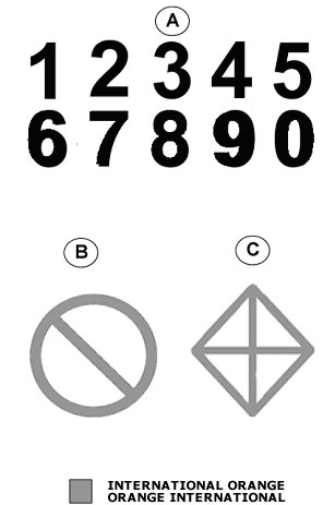
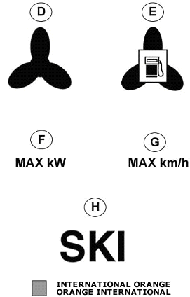
TABLE 2 / TABLEAU 2
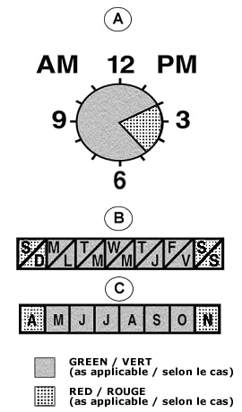

TABLE 3 / TABLEAU 3
FIGURE 1

FIGURE 2
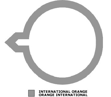
FIGURE 3

FIGURE 4
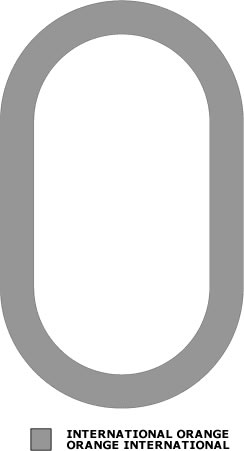
FIGURE 5

FIGURE 6

|